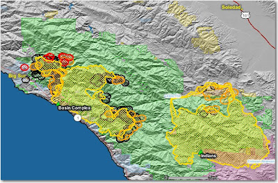
The Indians fire is looking very good. The firing on the north side along the Arroyo Seco drainage is complete and they are predicting official containment on July 3.
————-
Crews on the Basin Complex near Big Sur are constructing indirect firelines up to 6 miles out ahead of the fire, using some of the same tactics that were successful on the nearby Indians fire, indirect line and then burning the fuels between the line and the main fire.
On the south side, dozers and hot shot crews are constructing and firing out a line from the North Coast Ridge Trail, south to the coast near Big Black Rock south of Esalen.
The fire on the north side is burning around Big Sur, while crews, dozers, and engines are working on containment lines that are mostly indirect, and are firing out behind houses as needed.
The map below shows heat, in red, orange, and black, detected by satellites last night, with the red areas being the most recently burned. The yellow lines are the perimeters uploaded by the incident management teams. Click on the map to see a larger version.

