Updated at 8:30 p.m. MT, June 9, 2011: A damage assessment of the fire’s run through Greer last night revealed that 22 houses burned. More information. And the size of the fire has been revised again. Wednesday morning it was reported by the incident management team to be 389,000 acres, then Thursday morning, 348,235, and later on Thursday, 386,690 acres and for the first time, some degree of containment: 5%.
Information from the IMTeam released tonight:
Dozer line construction took place along Highway 260 going west from Eagar to Highway 373 junction; then southeast to Greer Lake in prep for burnout for tonight’s operational period. Firefighters are prepping with dozer line in the south end of Greer Valley heading southwest to Highway 273 at Sheep’s Crossing for an additional burnout. Dozer line will take place on the east side of Escudilla Mountain extending southeast towards Luna, New Mexico for burnout. All fuel moistures are extremely low.
Updated at 4:01 p.m. MT, June 9, 2011: Replaced map of north portion of Wallow fire with updated version.
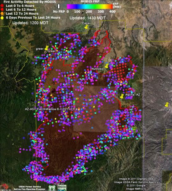
Updated at 2:57 p.m. MT, June 9, 2011: Added a new type of map, showing Fire Radiative Power, or fire intensity.
Updated at 11:56 a.m. MT, June 9, 2011: An update from the incident management team posted at InciWeb at 11:00 a.m. MT included information about evacuations, and this information:
- Size: 348,235 acres based on last night’s infrared flight
- 0% contained
- Structures lost: 16
- Fire Upate: Last night, fire crews concentrated their efforts prepping roads and dozer lines for burnout operations south of Route 851 and Circle Flat area that leads into New Mexico. Fire activity increased on the west side of the fire towards the communities of Greer and Eagar due to high wind and low humidity.Crews are currently stationed at Big Lake to reduce travel times, ensuring firefighter safety. Structural protection is in place in Greer, South Fork, Eagar, Alpine, Nutrioso, and Escudillo Flats. Firefighters will be conducting burnout operations on the northern and eastern portions of the fire to p limit the fire’s spread. Firefighters continue to hold line, mop-up, and patrol other areas of the fire. Creeping, smoldering, and active backing fire with short upslope runs was observed yesterday on the southern portion of fire. Firefighters are constructing indirect line and conducting burnout operations. Today southwest winds of 8-15mph with gusts to 25 mph are expected.
=================
Updated at 9:22 a.m. MT, June 9, 2011: added information about the 747 and DC-10 air tankers.
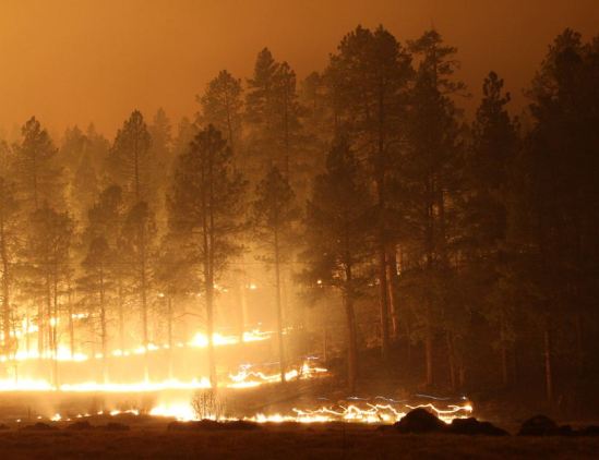
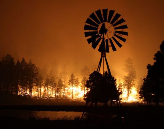
The Wallow fire burned through the small unincorporated community of Greer, Arizona Wednesday evening. Greer has a population of about 177 people and some tourist lodges. The incident management team posted this at InciWeb at approximately 10:00 p.m. Wednesday:
Fire has gone through Greer. We do not know the extent of the damage at this time. Firefighters are on scene in Greer conducting structure protection activities.
The last acreage reported was 389,000, a figure supplied by the incident management team Wednesday morning. That will no doubt be revised upward later today. They are reporting that the fire is 0% contained.
Very Large Air Tankers
KPHO, the CBS television station in Phoenix, reported on Wednesday that Evergreen’s 747 Supertanker was going to be used:
PHOENIX — Fire officials said they are bringing in a Boeing 747 supertanker that is retrofitted to drop a mile-long line of fire retardant.
Evergreen International Aviation said the supertanker has more than eight times the drop capability and twice the speed of any other federal air tanker currently fighting fires.
That report, even though it was picked up by numerous web sites and spread around the internet like, uh, wildfire, is incorrect. Wildfire Today talked with Steven Daniels who leads the 747 Supertanker program at Evergreen and he said the 747 is not being dispatched. As we reported yesterday in a story about the use of Very Large Air Tankers, the U.S. Forest Service is not interested in agreeing to an exclusive use contract with Evergreen or 10 Tanker Air Carrier for their 747 or the DC-10 air tankers.
However, Rick Hatton, the CEO of 10 Tanker Air Carrier, told Wildfire Today Thursday at 9:30 a.m. MT that one of their two DC-10 Very Large Air Tankers, Tanker 911, was en route to Phoenix Mesa Gateway airport to work on the fires. They still do not have any kind of a contract with the USFS, so they are being activated through a Call When Needed contract the company has with CalFire. This is the same methodology used when the DC-10 was used in Texas a few weeks ago. The other DC-10, Tanker 910, is on a fire assignment in Canada.
More information about the Wallow fire
Scroll down to see more information and the latest maps of the Wallow fire. We will update the maps on Thursday as new data is available.
A call center has been established by the White Mountain Joint Information Center (aka “Call Center”) for information, including evacuation information, regarding the Wallow fire. Their new phone numbers are 702-308-3238, 702-308-3357, 702-308-8227 , and their web site is 593.org. InciWeb is another source.
Here are some links to web cameras in the general area of the Wallow fire:
- Sunrise Ski Resort in Greer; web cam #2; may only be available from 7:00 a.m. to 5:30 p.m. MST.
- Springerville, Round Valley High School (Near Eagar); click Time-Lapse
- Molly Butler Lodge in Greer; click Time-Lapse
- Greercabin.com (a view of a forest and a thermometer, no sky view)
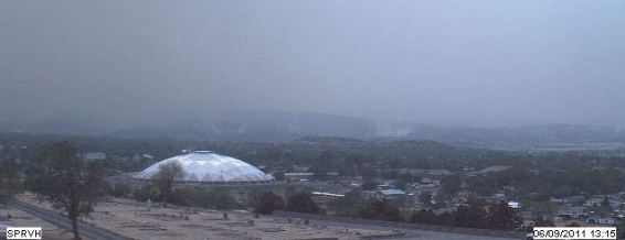
All three of the web cameras in the Greer area stopped providing new images after 9:00 a.m. on Wednesday, possibly due to a lack of electricity in the area. The web camera in Springerville is still in operation, but showed very dense smoke and limited visibility at a recorded time of 6:00 a.m. June 9.
Weather data from a RAWS weather station near Alpine, AZ and a RAWS station near Greer, AZ.
Photo galleries at ABC15, Flickr, and at MSNBC.
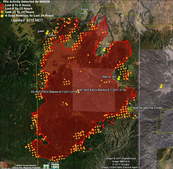
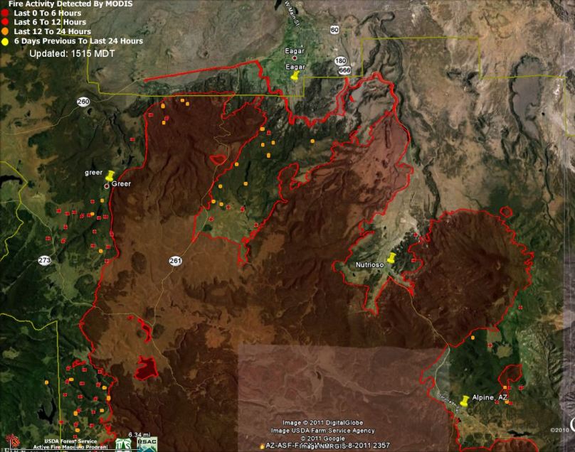
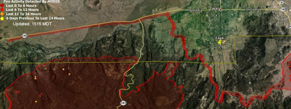
In the map below of the north portion of the fire, (click to enlarge it) you will see what appears to be a burning operation, parallel red lines very close together, north of the fire along highway 260 west of Eagar and along Rt. 76 south of Eagar.
Below is a new, to me, type of map, showing Fire Radiative Power or fire intensity. The colors of the dots indicate the relative intensity of the fire over the last six days. Compare the dot colors with the MODIS FRP legend at the top of the page.


Anyone know what fire agencies have been dispatched to this fire? My husband left for this fire this afternoon and haven’t received word if they made it or not.
Anyone know what fire agencies have been dispatched to this fire?
is the 747 down for repairs? evergreen has a big investment and no work to show for it. both planes would be nice for AZ. is there a resone for one and not the other? with 3 cities under fire, why would we not want both? Glad the feds have brought in the DC-!0
and thank you for the good work. keep us up to date.
Keep up the great work…
Why is it the forest service lifted the campfire restriction just days before the memorial holiday weekend?
THAT is the $64 million question.
Due to close cooperation with USFS in California, CalFire has agreements already in place with USFS. In this case CalFire pays the vendor, then submits submits an invoice for re-imbursement to USFS. It’s a very handy system and is exercised every summer. The catch, with exclusive use contracts, CalFire has first call on the DC-10 and will call it back if fires break out in California. Luckily it’s relatively slow in California right now.
Question: How can a DC-10 tanker be deployed to Arizona under a CalFire contract? Is it being loaned by the state of California under some sort of mutual assistance agreement?
CalFire explained the deployment of the DC-10 on their website:
Victorville – One of the nation’s only DC-10 Very Large Airtankers has been deployed from California to assist in fighting the raging wildland fire in Arizona. The request was made yesterday by the United States Forest Service. The aircraft, Tanker 911, took off this morning to help in Arizona from its base in Victorville.
The Forest Service is accessing the DC-10 through a call when needed contract CAL FIRE has with 10 Tanker, the company that operates the only two DC-10 Very Large Airtankers in the world. During peak fire season, CAL FIRE has an exclusive use contract with 10 Tanker to enhance its aerial firefighting fleet.
Thank you.
Suggestion how a series small directed bombs low profile controlled to snuff the fire. Follow up with air drops of chemical . Also I thought there was a a way producing clouds using dry ice .
Dry ice? Ive heard of using silver iodide crystals, but that’s used to seed clouds. There aren’t wny clouds (except smoke clouds). There also isn’t any humidity to condense out.