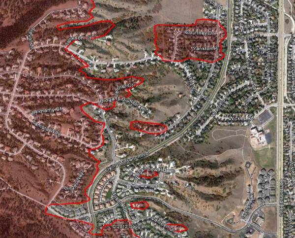
 (The map above is an example of how the the Waldo Canyon fire spread into the Flying W Ranch area of Colorado Springs on Tuesday, June 26. HERE is a link to a map that can zoom in to see more details. MODIS/Google)
Authorities searching through the rubble of the 348 homes that burned in the Waldo Canyon fire at Colorado Springs, Colorado found the remains of one person. A second person at that home and another nine are still unaccounted for that live in the areas that burned in the fire.
Firefighters wanted to do some burning out Thursday night to remove some of the fuels adjacent to the firelines but the humidity was too high. That same humidity also prohibited any additional spread of the fire, which has burned 16,750 acres and officially is 15 percent contained at a cost to date of $5.2 million.
President Obama will tour the fire area on Friday to inspect the destruction. Officials said this would not interfere with fire operations and the number of closed roads will be less than you would typically encounter during a Presidential visit. He will most likely fly in to Peterson Air Force Base at Colorado Springs and we are thinking that he may have a photo op with the military MAFFS C-130 air tankers working out of the base.
If the president makes any public comments during his visit it will be interesting to see if he mentions wildland fire preparedness, such as the reductions over the last few years in funding, and the reduced number of firefighters, equipment, and air tankers.
The City of Colorado Springs announced that they will release a list of the damaged homes by mid-morning on Friday. It will be posted on the city’s web site at http://springsgov.com/
A slide show with aerial photos of the destruction in the urban area is jaw-dropping.


One source of fire mapping information that you do not mention (thankfully!) is the Google Crisis Response DigitalGlobe imagery. Here’s the link- http://google-latlong.blogspot.com/2012/06/us-wildfires-new-google-crisis-map.html?utm_source=feedburner&utm_medium=feed&utm_campaign=Feed%3A+blogspot%2FSbSV+%28Google+LatLong%29
I found it to be misleading because they are using the near-IR band (which shows healthy vegetation, and so could be useful for showing ash layers) and colored it in RED shades, so it gives the erroneous impression that all lawns and golf courses are on fire!