UPDATE: July 6, 2012: We posted an update on the Oil Creek fire HERE.
==============
We posted updated information about the Oil Creek fire July 5, 2012.
===================
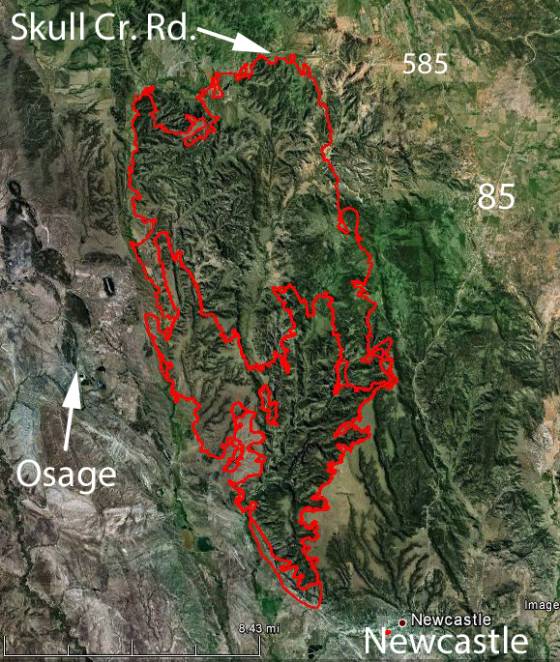
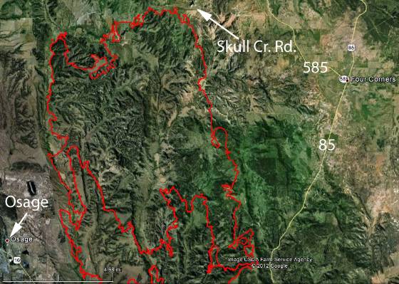
The Oil Creek fire 2 miles northwest of Newcastle, Wyoming doubled in size Tuesday. Responding to Red Flag weather conditions and strong winds from a thunderstorm the fire ran to the north to Skull Creek Road adding another 34,000 acres, bringing the total to approximately 56,000 acres.
These maps show the perimeter from Monday night and the perimeter at 12:07 a.m. Wednesday.
The town of Osage was evacuated on Monday, affecting 425 people. As of 5 p.m. on Tuesday the fire was 20 percent contained. Firefighters could not get out ahead of the rapidly moving fire, but they were able to do some effective work using flanking tactics.


6 July 2012 Quoting from InciWeb (http://www.inciweb.org/incident/2985/):
“According to Weston County Homeland Security Facebook page, Level 1 evacuations are lifted for Osage, and for Newcastle residents living north of the railroad tracks, from the city shop to MacArthur Avenue. Also, the Level 2 notice is now lifted from the following roads: Skull Creek, Oil Creek, Plum Creek, Big Plum Creek, NW Table, Ertman and Elk Grove Trail.
“Weather: Last night’s wetting rain helped with suppression efforts. Weather is expected to moderate Friday through Sunday, with temperatures in the lower 80’s and higher relative humidity.
“What’s New: Yesterday’s gusty winds tested the lines, but to everyone’s satisfaction, they held. Crews were able to make good progress on the line. Much of the work today is focused on mop-up along Oil Creek Rd. and the NE section of the fire. Crews will continue to mop up and patrol for hot spots and begin rehab within the fire perimeter.”
Thank you. We live about 25 miles by road from this fire. It is great to finally have a site to get info. I work with a woman that the fire came up to their ranch, burnt the grass and went around them, they did not have trees near any buildings. Thanks again
I was on the inciweb and noticed that they have updated the map and have a icon in the center of the fire map but nothing comes up explaining this icon when you click on it. Would anyone know what this means.
Thanks for your good work Bill.
There is a new website up to help out the Weston County folks. http://www.westoncountywildfire.org