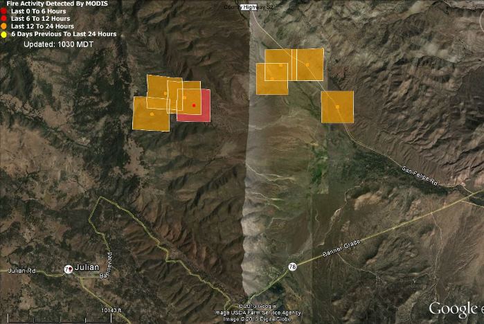
(UPDATE at 7:18 a.m. PT, May 26, 2013)
CAL FIRE is reporting the fire has burned 2,650 acres and is 90 percent contained. Resources assigned include 612 personnel, 50 engines, 23 hand crews, 6 dozers and 11 water tenders.
****
(UPDATE at 12:19 p.m. PT, May 25, 2012)
After overnight GPS mapping, the fire is now listed at 1,800 acres and 70 percent containment.
****
(UPDATE at 5:30 p.m. PT, May 24, 2013)
The incident commander of the San Felipe fire northeast of Julian, California is calling it 1,850 acres and 70 percent contained.
****
(UPDATE at 3:27 p.m. PT, May 24, 2013)
The images from the Mt. Laguna camera show that the San Felipe Fire is not putting up as much smoke as it was earlier today. CAL FIRE, in a 2:30 p.m. update, reports that it has grown to 1,800 acres and is still 60 percent contained.
****
(Originally published at 10:25 a.m. PT, May 24, 2013)
A prescribed fire in Anza Borrego Desert State Park 4 miles northeast of Julian, California got away from firefighters around noon on Thursday. A change in the wind direction is being blamed for the escape, now named the San Felipe Fire, that as of Thursday evening had burned 1,500 acres and was 60 percent contained.
The Ramona Sentinel reported that CAL FIRE conducted the prescribed fire.

As of 6:15 p.m. on Thursday the resources assigned to the San Felipe Fire included 644 personnel, 65 engines, 24 hand crews, 5 air tankers, 7 helicopters, 5 dozers, and 13 water tenders.
An animation of still photos taken from Mt. Laguna Thursday afternoon is available HERE. A window may pop up outside of your browser. It will take a while to load, and it may not work in the Chrome browser.
The latest still image is available HERE.
The fire is in the same general location as the Vallecito Lightning Complex of fires that burned more than 15,000 acres in August.

OOPS! Sorry about my last. It’s not the Felipe Fire but the General Fire, a new start a few miles southwest of it.
LR
Hey Bill! It might yet be an oops in the making. The Felipe Fire is putting out a pretty good horizontal cloud of smoke to the SE at 15:00 hours. Looks like the Ramona AA base (http://anr.ucsd.edu/cameras/L/hpwren-iqeye7.jpg) is active.
The smoke is passing a few miles to the south of an automated weather station in the Narrows (http://raws.wrh.noaa.gov/cgi-bin/roman/meso_base.cgi?stn=NRWSD ) 13.5 miles east of the Felipe Fire. Both Mt. Laguna (http://anr.ucsd.edu/cameras/L/ml-n-mobo-c.jpg) and Toro Peak (http://anr.ucsd.edu/cameras/L/tp-s-mobo-c.jpg) show it pretty good as of now. BTY, that’s my home valley of 37 years just left of center in the Toro image.
And a good Memorial Day to you!
LR
Hi Bill! It seems CalFire really was “playing with fire” with the 111 acre San Felipe VMP (Vegetation Management Program) prescribed burn. As you well know, spot forecasts are not sacrosanct particularly here in San Diego county where a spine of mountain ridges separates the moist Pacific coast from the dry desert . Essentially a dam, depending on how deep the marine layer gets, these ridges can determine local relative humidities and wind conditions on the desert side.
Other than the Area Forecast Discussions out of the San Diego National Weather Service office which pointed to some potential “no go” conditions that really suggested, No Go!, the Spot Forecast from the afternoon before relied on the only automated reporting stations nearby. All (several) within 6 miles of the burn but all atop that marine layer dam at 1600-1900+ feet above the prescription in San Felipe Valley which interfaces with the true desert floor. At the northern end of San Felipe Valley is a miles wide saddle of sorts, many hundreds of feet lower than the “dam”, a spillway that can easily funnel marine layer humidity and wind into the valley and, ….. turn it off.
San Felipe Valley is a very subtle and finicky place meteorologically and fire-wise speaking. Less than 6 miles up the valley CDF (now CalFire) in 2002 lost an essentially done Pines Fire which then blasted through Ranchita, burning an additional 10,000 acres.
I wonder if agencies involved wanted/needed to accomplish this burn before everyone was caught up in “real” wildfires and prior to the end of California’s fiscal year, June 30. Hmmm. Oh! The prescription was within San Felipe State Wildlife Area administered by California Fish & Game.
LR
Getting kind of old hearing the excuse ” A change in the wind direction is being blamed for the escape”. Isn’t Standard Fire Order #3 “Base all actions on current and expected behavior of the fire?
Doesnt that apply to planning as well?
Oops! Strong work CDF