(UPDATE at 9:20 a.m. PDT, July 21, 2013)
Monsoonal storms brought heavy rain to the Mountain Fire west of Palm Springs early this morning. The weather station at the top of the Palm Springs Aerial Tramway just north of the fire measured 1.61 inches between 11 p.m. Saturday and 8:53 a.m. today. The Keenwild weather station 5 miles southwest of the fire had 0.23″ since midnight. A flash flood watch was issued for the fire area as well as the Riverside County Mountains, San Diego County mountains and San Diego County deserts. There is a 55 to 80 percent chance of more rain through 10 p.m. with additional accumulations of up to 0.60 inch.
This morning the incident management team said firefighters are taking advantage of the break in the weather:
With diminished fire activity, firefighters made great progress with line construction particularly along the East side towards Palm Springs. Although conditions were hazardous and some crews were taken off the line due to the severe weather, firefighters continue to fight the fire aggressively where possible. Todays priority for fire operations is focused at the northernmost part of the fire with crews at the Palm Springs Aerial Tramway constructing direct hand line at the fires edge to reduce the threat to Idyllwild and surrounding communities.
The U.S. Forest Service has been using their new night flying helicopter and air attack ship on the fire, and proudly produced this graphic.
****
(UPDATE at 7:25 a.m. PDT, July 20, 2013)
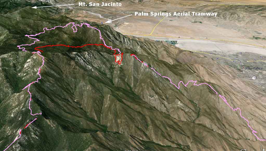
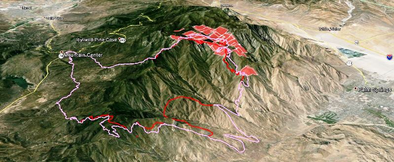
The Mountain Fire continued to spread to the north Friday, coming closer to the highest point in the area, Mt. San Jacinto, and within 0.7 mile of the Palm Springs Aerial Tramway. The 3-D map above which shows the north portion of the fire illustrates the very steep slopes the firefighters have as their work environment. The fire spread very slowly on the south side, while the east and west sides were relatively quiet Friday.
A major change in the weather is in the works, with the forecast for the higher elevations calling for much higher humidity and a 30 to 40 percent chance of showers over the next 48 hours. This should slow the fire’s spread and give firefighters a better opportunity to construct more direct fireline.
The incident management team has produced a map of the fire.
****
(UPDATE at 9:23 a.m. PDT, July 19, 2013)
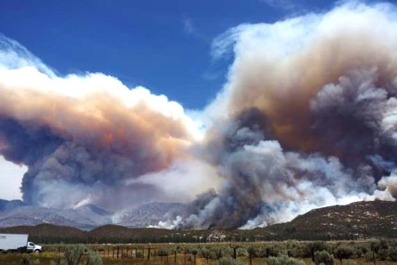
The variable wind direction Thursday caused the fire to spread, as expected, in multiple directions. It continued to progress in the Tahquitz meadows area, but firefighters on the ground assisted by aircraft, including two military MAFFS C-130 air tankers from the California Air National Guard, held the fire at a ridge. The fire remains active on the north side and continues to threaten the community of Idyllwild, according to the Incident Management Team.
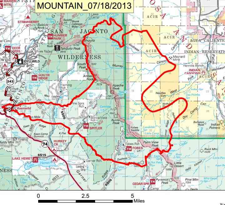
The IMTeam produced a very readable map, below. It was released at 6 a.m. July 18 and contains the fire perimeter as it was known late in the day on July 17.
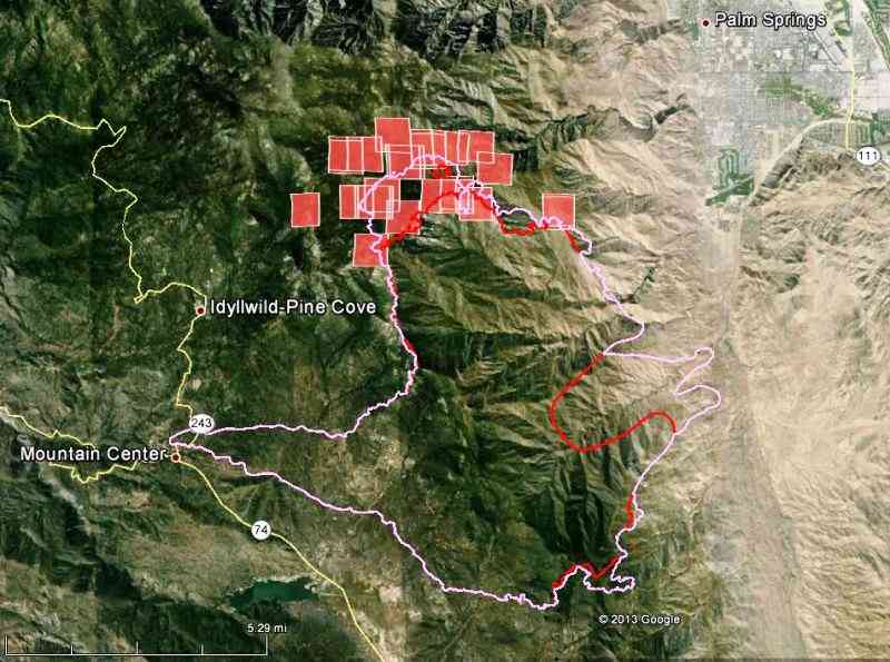
We put together the following maps using data from various sources.
****
(UPDATE at 7:41 a.m. PDT, July 18, 2013)
We collected some interesting videos of the Mountain Fire HERE.
The maps below show the perimeter of the Mountain fire as it was mapped at 9 p.m. Wednesday.
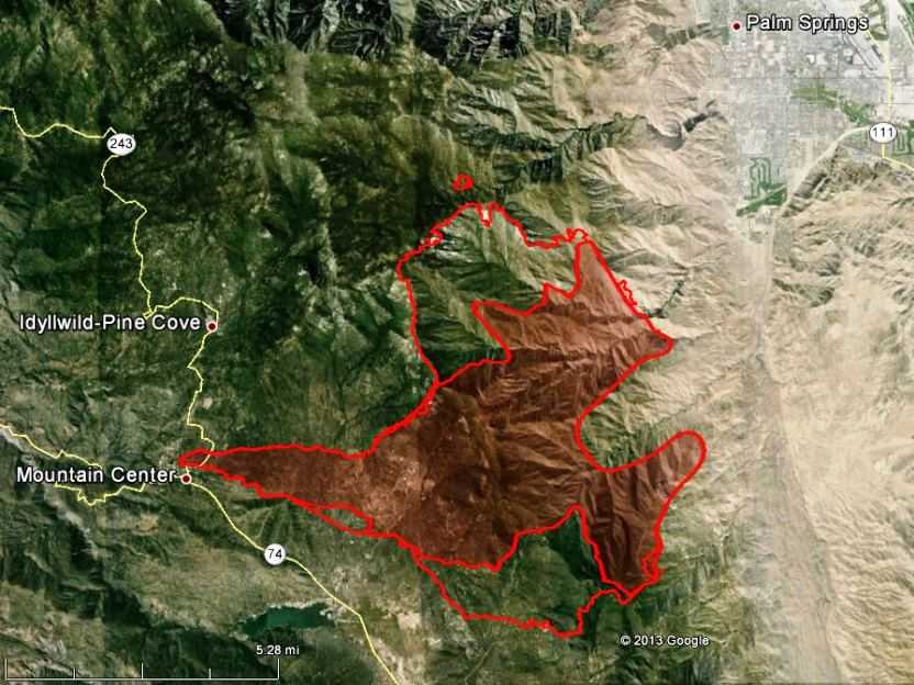

The Mountain Fire grew substantially on Wednesday on the north and the south sides. Thankfully for the evacuated residents of Idyllwild the fire did not come much closer to their community and is still about 1.5 miles away from the populated area. On the north side at 9 p.m. Wednesday it came to within 1.5 miles of Tahquitz Peak and was 2 miles away from the Palm Springs/mountain tram.
The fire is listed at 19,400 22,800 acres and the incident management team is calling it 15 percent contained.
There was virtually no wind recorded at the nearby Keenwild weather station overnight. The forecast for Thursday includes moderate wind speeds of 5 to 9 mph but from variable directions, which could cause a problem for firefighters and interesting fire behavior on the steep slopes. The relative humidity will be in the low teens.
The resources working on the fire include 2985 personnel, 228 engines, 17 helicopters, 10 fixed wing aircraft (including two DC-10s), 51 hand-crews, 21 water-tenders, and 15 dozers.

HERE is a link to a video with some interesting interviews about the fire.
****
(UPDATE at 7:25 p.m. PDT, July 17, 2013)
**Additional evacuations for the Mountain Fire in southern California**
The following notice was issued at approximately 6:45 p.m. PDT Wednesday:
“The following areas are being evacuated: The communities of Idyllwild and Fern Valley, US Forest Service Campgrounds and the US Forest Service Wilderness and the Mt. San Jacinto State Park are also included. This evacuation notice does not include the areas of Pine Cove, Mountain Center, and Poppet Flat. The Trails End Community at the very top of Morris Ranch Road is under an immediate Evacuation Notice!”
More information about the evacuations can be found at the fire’s InciWeb page.
The Incident Management Team, on their Inciweb page in the urgent, bold face, new evacuation section, refers evacuees to this map:

The map above, the only one on the IMTeam’s InciWeb page, is a poor photograph of a paper map intended to be used by firefighters, and the result is a product that is virtually worthless to the general public needing urgent, up to date information about the fire, which is on it’s third day now. Surely the Type 1 Incident Management Team, which has been running the fire for over 24 hours, can produce a better map than this for the nearby residents who need usable, readable, information about the fire.
We have the two maps below that show the fire perimeter as of 1:59 a.m. Wednesday. While they don’t show the fire’s progress Wednesday afternoon, at least they should be somewhat readable for the general public. Click on them to see larger versions.


The coordination center reported at 7 p.m. the fire had burned 19,400 acres. They explained that a wind shift caused the change in the fire behavior today. The Keenwild weather station showed that since 7 a.m. the wind has been generally from the west or southwest at 0 to 7 mph, but the gusts have been increasing, reaching 10 to 16 mph in the afternoon. The humidity recovery Tuesday night was poor, and Wednesday morning at 9:17 it was 5 percent. It remained in the single digits until late in the afternoon.
The Incident Management Team included this in their message about the new evacuations:
The fire has transitioned from a wind driven fire to a fuel and topography driven fire. This condition has caused a shift in the direction of spread necessitating the evacuation as the fire moved to the west this afternoon and presents a threat to nearby communities. With vegetation moistures at record lows fire spread has been extreme and dangerous.
This is the best choice in a difficult situation. The highest priority is to protect the lives of citizens in the immediate area of the blaze.
****
(UPDATE at 10:15 a.m. PDT, July 17, 2013)

This updated map of the Mountain Fire, which is between Palm Springs and Idyllwild, is looking toward the northwest. The Incident Management Team said the fire has burned 14,200 acres it is 10 percent contained.
The Southern California Coordination Center reports that 23 structures have been lost. The fire continues to move toward Palm Springs, Cove-communities, and Garner Valley.
The fire crested the mountain at over 6,000′ above sea level and burned down into the desert to 600′.
After 9 p.m. Tuesday the wind measured at the Keenwild weather station was almost nonexistent through Wednesday morning at 8:17 a.m. The station recorded zero mph except for one hour when it was blowing at 1 mph. But the wind is predicted to increase during the day on Wednesday to 13 mph gusting out of the west at 20 mph by 5 p.m. This should lead to increased fire activity.
****
(UPDATE at 7:44 p.m. PDT, July 16, 2013)
The Incident Management Team reports that the fire has burned about 9,000 acres.
The structures that have burned include:
- Bonita Vista – 3 mobile homes and 3 residences were destroyed, 1 residence sustained damage.
- Pine Springs – 1 commercial building, a workshop, garage, and cabin were destroyed.
- Zen Mountain Center – No damages.
- Plus 11 outbuildings and 4 to 6 vehicles.
Even though those structures were lost, firefighters were able to save a substantial number of homes.
The Southern California Coordination Center reported at 6 p.m.:
Incident is currently moving towards Palm Springs and cove communities. Structures, watershed and cultural heritage sites remain threatened. If fire changes direction a larger structural threat will exist. Fire is burning is steep inaccessible terrain and amongst bug-kill timber.
Incident command transitioned from unified to a type 1 IMT team (Pincha-Tulley) at 6 p.m. today.
Resources assigned to the fire include 2,241 personnel, 98 engines, 15 helicopters, 10 fixed wing aircraft (including at least one DC-10), 73 hand-crews, 6 water-tenders, and 10 dozers.
****
(UPDATE at 3:15 PDT, July 16, 2013)

****
(UPDATE at 12:34 p.m. PDT, July 16, 2013)
The Incident Management Team reports that structures have been damaged and destroyed in the Pine Springs Ranch area in Apple Canyon. Riverside County Office of Emergency Services has assembled a Damage Assessment Team to determine the extent of property damage and loss.
There are mandatory evacuations for the Living Free Animal Sanctuary, the Fleming Ranch, Bonita Vista Community (20 homes), the Zen Mountain Center, Andreas Canyon Club, and 24 homes south of Palm Canyon Drive.
The size is estimated at 8,000 acres
The fire is being managed under unified command by the US Forest Service, CAL FIRE Riverside Unit and the Riverside County Sheriffs Department. The cause of the fire is under investigation

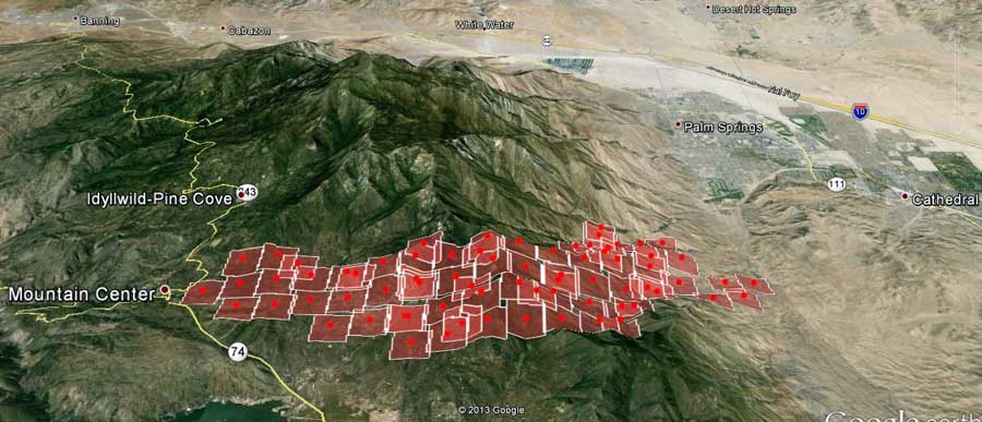
Below, we have a better map of the Mountain fire, showing in 3-D that it burned across the mountain range east of Idyllwild and into the desert south of Palm Springs, a distance of about 8 miles.
****
(UPDATE at 6:30 a.m. PDT, July 16, 2013)
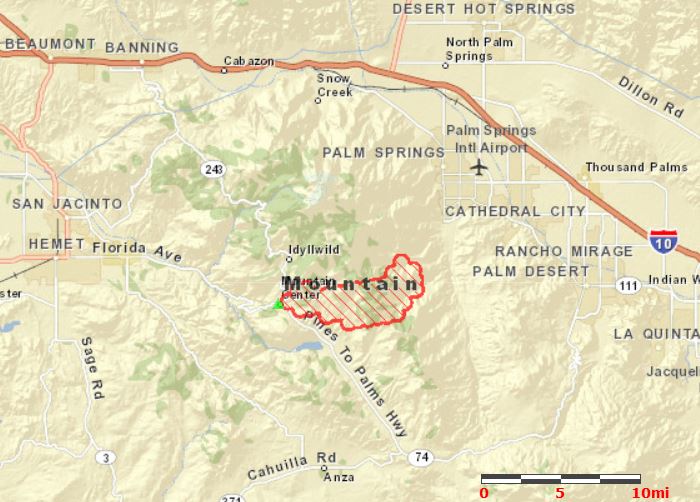
The Mountain Fire which started near the intersection of Highways 243 and 74 near Mountain Center and Idyllwild in southern California Monday afternoon has grown to 4,700 acres, according to the U.S. Forest Service. As you can see by the map of the fire above, it spread rapidly to the east, expanding about eight miles from its origin.
****
(Originally published at 8:10 p.m. PDT, July 15, 2013, updated at 8:52; we will update this article as needed)

The Mountain fire started near the intersection of Highways 243 and 74 near Mountain Center (see map above) 83 miles southeast of Los Angeles and about 3 miles from Idyllwild at about 1:43 p.m. PDT Monday, and by about 6:30 p.m. the Type 2 incident management team that was ordered had been cancelled and replaced with an order for a Type 1 IMTeam. Today the fire is in a unified command with the San Bernardino National Forest and CAL FIRE.
The incident commander is estimating the size at 1,000 acres. The Coordination Center reported that some structures have burned in the Pine Springs Ranch area. Evacuations are in effect for the Bonita Vista and Apple Canyon areas. (More information about evacuations.)
The nearby Keenwild weather station recorded a temperature of 90 degrees Monday afternoon, a relative humidity of 15 percent, and very variable winds of 5 to 16 gusting to 27 mph. The forecast for Tuesday predicts a temperature of 95, relative humidity of 15 percent, and northwest winds in the afternoon of 10 to 15 mph gusting to 25.
Some of the radio traffic can be heard HERE.
Monday afternoon seven air tankers and eight helicopters were working the fire. One of the DC-10s has been ordered for Tuesday. The US Forest Service night flying air attack and helicopter are working the fire Monday night.
As you can see in the photo below, the fire can be seen on the right side of the image taken from the web cam at Toro Peak.
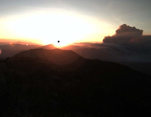
It can also be seen from the web cam at High Point. which is about 27 miles southwest of the fire.


I think your updates, especially the maps with the lines representing where the fir in and was were fantastic. I was especially following the progress of the fire towards Idyylwild. I spent a couple of weeks every summer from the 7th grade through the 12th grade at a church camp called Taquitz pines–near the town of Idyylwild. Thanks for being so thorough
Here is a great interactive map from weatherunderground.
Hey thanks for the weather link fix, cheers.
This fire saddens me as I use to live on Table Mountain in Anza for almost 24 years before moving to Sweden.
Its so sad that people can’t behave them selves people in Idyllwild are scared and loosing enough and some lowlife has to take advantage and steel I hope the little creeps get nailed. To the people that live up there my hart and prayers go out to you and to the firefighters to be safe. God bless you all.
Did any of the structures at Fleming Ranch on Bonita Vista burn?
ok, went to the esri.com site for the map. thanks
On broadcastify they’re laying out targets for retardant drops … lower down the slope on southern end …
hey, hard to read your maps, mapbe you could make the boundries yellow ?
up here in idy…
ESRI has an interactive map of the fire:
http://tmappsevents.esri.com/website/wildfire-responsive/index.html
With the difficulty of access to the actual fire, are the engines working mostly on structure protection?
With the current fire and fuels conditions…. nothing is “normal” in fire behavior that we are seeing this year..
I watched full and successfully placed loads of retardant yesterday from T-910 and T-911, as well as several other Type 2 and Type 3 air tankers, but after each run, the fire continued to burn actively through the retardant.
The old and “time tested” tactic of ANCHOR and FLANK seems to be the safest and most effective tactic once again.
At 1800 yesterday, I was glad to have safely made it through the day with positive progress made towards incident objectives…. and an IMT taking over the management of the fire.
On another “website”, folks are bagging on the management of the incident….. As the day #2 IC… I have to say…. Huh???
2985 firefighters, including 228 engines, 17 helicopters, 10 fixed wing aircraft, including a (2) DC-10(s), 51 hand-crews, 21 water-tenders, and 15 dozers.
I think we more than ramped up and mobilized appropriately to address the risk and threat.
I might be wrong though… but hey… how many qualified ICs are out there anymore????
Ken,
Your observations on the fire’s ability to burn through fresh retardant drops are a breath of fresh air on this site. Thank you!
The most important objective on all of these fires is to keep people safe. Especially the people considered ‘resources’ to battle the fire. Any other objective is secondary, including control of the fire or saving a house. We’ve got enough heroes in this business as it is.
Thanks for your efforts.
So sad! California is my birthplace. Parents had a desert home in Yucca Valley. Mother always loved and enjoyed Palm Springs. Hope the firefighters can get things under control very soon. I live in Idaho now, but a lot of my heart is still in CA.
Mandatory evacuations of Idyllwild & Fern Valley started at 5:15 pm. We have a cabin in upper Fern Valley – hard to get news of exactly how close the fire is and which direction it is burning.
We evacuated from Idy last night. My friends in Pine Cove say the fire hasn’t crested the ridge and is still about 1.5-2 miles out. The fire folks are concerned regarding unpredictable winds for today ,but seem to be of the opinion that by tomorrow the winds will shift once again to the west. Hope that helps.
Thanks. We were able to go up last night and gather some items around 10PM. Very eerie to see all the dark businesses and cabins. Huge firefighter presence and lots of patrols. Was sad to hear some looting had been attempted downtown, but perpetrators were caught almost immediately.
Knowing how you feel about air tankers, here is one dropping on the Mountain fire.
http://blog.pe.com/wp-content/uploads/2013/07/E_MCFIRE_0717_kmaaa.jpg
The Press-Enterprise is the major paper for Riverside county and has a pretty good news team.
7/17 – 7 am, now reporting 14,200 acres – 10% contained
RE:MODIS
You report that the MODIS hot spots could be off by up to “1 mile” when in reality is more like 1 km. While this 1 mile explanation is conservative – you may want to link out to the MODIS website so people can dig deeper to find out more. https://earthdata.nasa.gov/data/near-real-time-data/faq/data
Here is how MODIS horizontal accuracy is typically explained “The center point location of the 1km (approx.) pixel flagged as containing one or more fires/hotspots (fire size is not 1km, but variable).”
Paul, correct me if I’m wrong, but I think what you are saying is that the heat source can be anywhere within the 1-kilometer square, or pixel. I get that. But what I have observed on many occasions is that the entire pixel can be up to a mile away from any heat source that is detected by firefighters mapping the fire or the thermal infrared line scanners in the USFS fixed wing aircraft that fly much closer to the fire than the MODIS satellite. Sometimes the pixel is erroneously placed more than a mile from the heat source.
An example is the MODIS data right now for the West Mullan Fire which is about 50 miles northwest of Missoula on the north side of Interstate 90. The lastest MODIS data, from 1935 UTC July 16, shows a pixel on the south side of the Interstate. I just talked with the PIO at the fire who said there is no fire south of the Interstate. In this case the error is at a minimum between 0.45 and 1.25 miles, depending on what side of the pixel you measure from, and depending on how far north of the highway the fire is. The center of the pixel is 0.84 mile from the Interstate, and the fire is some distance north of the Interstate.
I wonder if the MODIS folks are able to calibrate the accuracy of the sensors, or if they ever ground truth the data.
MODIS is a very valuable service, but it can’t be used for accurately mapping the perimeter of a fire. That’s why God invented the thermal infrared line scanners in the USFS fixed wing aircraft.
Bill,
whole lots of “it depends” with respect to geolocation accuracy.
The 1km reflects “pixel size” but not instrument pointing accuracy or the resulting geolocation accuracy. Resolution is only 1 km if the satellite is looking straight down. At significant scan angles the 1 km pixel resolution might be up to 2 km long and 1 km wide. Then you have to add the sensor pointing uncertainty [say another 250-300mtrs] and it might be possible to see the kind of errors you are talking about.
A long time ago I was told that the MODIS people use multiple georeference points to keep the system imagery accurate. Don’t know what they use today.
if anyone has any info on pine springs ranch i need to know. its at the very end of apple canyon road and was my summer job. thank you so much!
An email was sent to families tentatively estimating that perhaps Friday campers can head up to attempt luggage/gear recovery. Wk 2 is cancelled and $ refunded unless otherwise designated as donations.
Is the fire still burning?
Yes. I just posted a new photo taken from Toro Peak that shows it is still very active. This fire will not be put out quickly unless the weather changes dramatically.
thank you for the information. I’ve been trying all night figure out if it cancels safe. watch the kids have been is actually. having worked there for a couple of summers I have many friends working there and also many of my friends children are there this week.
praise God all got out and hopefully the structures and animals will all be safe as well.
They evacuated to the Hemet SDA Church; all campers and counselors are accounted for; if only a cabin, commercial bldg., garage and workshop is damaged/lost, and the animals safely evacuated, it could’ve been much more devastating. Thank you, Lord, and thank you Mr. Gabbert for your time/effort and knowledge — this site is a valuable source of information!
Frustrated that the news thinks that the idiots rioting for no reason is more important that a huge fire that can claim many lives and property. I have a cabin in Idyllwild and have been trying to get info all night with zero help from the news. Thanks for the info.
Yes, that is sad, but never underestimate the Media’s desire for striving after the most sensational story. It’s called ratings and they’ll even go as far as to creating and add fuel to the fire so to speak, if it means fanning the flames of even such a nonevent such as this. Incredibly, there was a 17 year old black youth who was murdered in Chicago by Gang members for refusing to join that Gang. Why aren’t people protesting and supporting that dead young man ?
I use to live up there and just yesterday wrote about some of the experiences within the realm of the natural world along much of that section of Highway 243 which may now be history. Glad I got photos this past April/May 2013. My biggest fear will come this weekend when southeastern monsoonal flow kicks in. This may push any live Hot-Spots back into Tahquitz Mountain towards Idyllwild/Fern Valley and most certainly blow it further up westwards into Mount San Jacinto Wilderness Park. I think this will go well beyond a month for FULL containment.
So happy to hear all the kids were evacuated safely! Praying the camp will be spared! Just picked my camper up last week and visited Living Free Animal Sanctuary. Praying all the animals are safe as well. May the firefighters get it knocked down quickly…
Thank you for the info; drove from San Diego to pick up my camper I dropped off YESTERDAY @ Pine Springs Ranch Summer Camp; anxiously scouring the ‘net hoping to see the horses left behind were evacuated safely as well. Your website/links is most helpful. Please pray w/us for the campsite — most importantly for the frightened creatures left behind. Thank God the kids were evacuated safely.