(UPDATED at 7:38 a.m. PT, July 28, 2015)
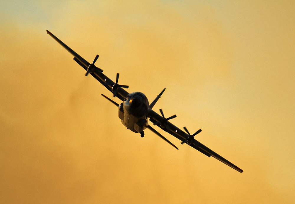
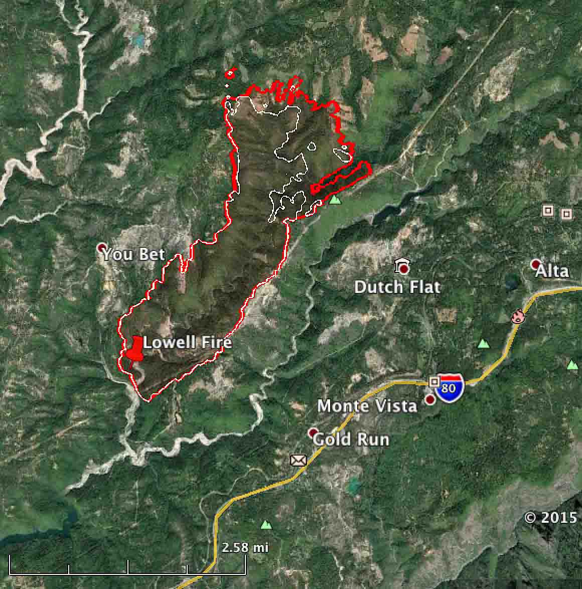
The Lowell Fire 7 miles east of Grass Valley, California grew by another 500 acres to 2,233 acres on Monday, chewing up more ground on the north side as it continues to move through the Steephollow drainage approaching Long Point. Firefighters have been mostly successful so far in keeping the fire from crossing the high-voltage electrical transmission line on the ridge just east of Steephollow.
At a weather station near the fire on Monday the temperature reached 90 degrees, the relative humidity bottomed out at 16 percent, and the wind was 2 to 5 mph with gusts at 8 to 13. Conditions on Tuesday will not be extreme, but the temperature at the fire will reach the mid-90s and the relative humidity again will be in the mid-teens, but the wind will be moderate at 2 to 8 mph switching from the southeast to the west in the afternoon.
Early Wednesday morning between 2 a.m. and 7 a.m. the wind will increase to 14 mph with gusts to 20 out of the east, which could test some of the firelines on the west side of the fire or spread the north end of the fire in a different direction than we have seen since the fire started July 25.
Mandatory Evacuations are in effect for Red Dog Road East of Greenhorn Creek, You Bet Road East of Greenhorn Creek, Chalk Bluff, and Lowell Hill Roads. An evacuation advisory is in place for the Cascade Shores Community.
As of Tuesday morning 2,277 personnel were battling the fire.
****
(UPDATED at 8:33 a.m. PT, July 27, 2015)
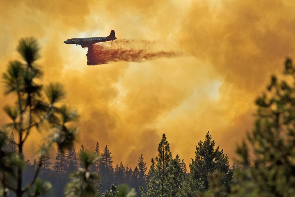
(More photos of air tankers working on the Lowell Fire are at Fire Aviation.)
The Lowell Fire northeast of Sacramento was very active on Sunday, spreading for another 1.4 miles to the north. The growth was accelerated by airborne burning embers that generated spot fires a quarter of a mile in front of the main fire. It continued to move up through the Steephollow drainage and crossed over Chalk Bluff Ridge into the South Fork Greenhorn drainage.
Access to the fire is difficult for the 1,424 firefighters working to suppress the blaze which has now burned 1,700 acres. Other firefighting resources on the fire include 104 engines, 42 hand crews, 14 helicopters, 39 dozers, and 6 water tenders. The number of air tankers varies throughout the day.
Sunday night CAL FIRE released additional information about the four fighters that sustained burns on July 26:
Early [Sunday] evening, two CAL FIRE and two U.S. Forest Service firefighters suffered burn injuries while battling the Lowell Fire in Nevada County. The firefighters were airlifted from the fire and transported to UC Davis Burn Center in Sacramento.
The two CAL FIRE personnel and one of the U.S. Forest Service firefighters are likely to be treated and released [Sunday] evening. The remaining U.S. Forest Service firefighter is being admitted with serious burn injuries.
CAL FIRE has activated one of its Serious Accident Review Teams to review the incident.
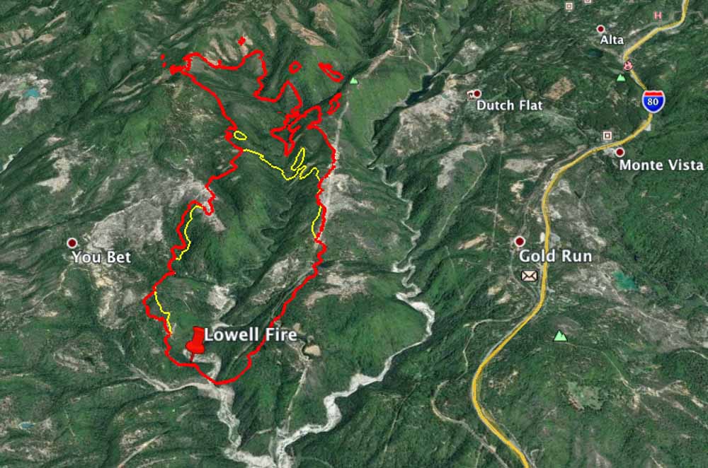
Below is a 3-D map of the Lowell Fire at 11 p.m. on July 26.
****
(UPDATED at 9:02 p.m. PT, July 26, 2015)
Four firefighters on the Lowell Fire northeast of Sacramento sustained burn injuries on Sunday. They were flown to a hospital but very little other information is available. When we find out more we will post it HERE.
The fire was active again today, but the official acreage did not increase. CAL FIRE Public Information Officer Daniel Berlant distributed this information via Twitter Sunday evening:
While fire activity did increase last this afternoon the fire remains 1,500 acres & 15% contained. Over 1,100 firefighters at scene.
****
(UPDATED at 10:10 a.m. PT, July 26, 2015)

The Lowell Fire west of Interstate 80 near Gold Run, 46 miles northeast of Sacramento, is still active Sunday morning. Saturday night the spread of the fire slowed, but there is still a concern at the head of the fire. It burned rapidly Saturday toward the north in the Steephollow Creek Drainage in an area where access to the fire is very challenging.
Below is a 3-D map of the Lowell fire, looking northeast, showing that at 9 p.m. Saturday night it was primarily confined to the Steephollow drainage.
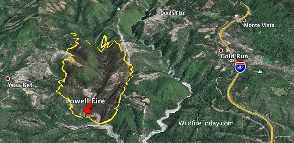
Better mapping overnight resulted in a decrease in the reported size — 1,500 acres now rather than the 4,000-acre estimate from Saturday evening.
Mandatory evacuations are in effect for the You Bet, Red Dog, Lowell Hill and Chaulk Bluff areas.
Resources assigned to the fire include 771 personnel, 81 engines, 30 hand crews, 9 air tankers, 12 helicopters, and 12 dozers.
Investigators are no longer looking for the vehicle of interest in connection with the fire.
****
(UPDATED at 7:03 p.m. PT, July 25, 2015)
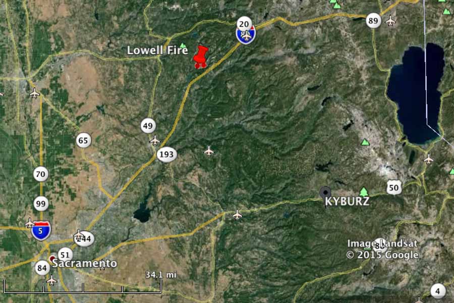
The Lowell Fire started Saturday afternoon and four hours later had burned about 4,000 acres west of Interstate 80, 46 miles northeast of Sacramento. It is about 7 miles east of Grass Valley in the Sleepy Hollow Creek area west of Alta and is spreading to the north in Nevada County. Air Attack reports that it is igniting spot fires 1/2 mile out in front.
Mandatory evacuations have been ordered for Red Dog, Chalk Bluff, You Bet, and the community of Cascade Shores. An advisory evacuation is in place for the north side of I-80 from Gold Run to Alta in Placer County.
Investigators are asking the public’s help in looking for a vehicle of interest that was in the area when the fire started. It is a lifted 4×4 white Jeep Wrangler without a top and has a black roll bar and no front doors. It was seen in the Gold Run/Dutch Flat area around 2:30 p.m. Anyone with information should contact the Placer or Nevada County Sheriff’s Department.
A short time after the Lowell Fire started it caused the electrical power to be interrupted in a major transmission line. One of the casualties of the loss of power was the air tanker base at the airport just east of Grass Valley, just 5 miles from the fire. Without power, they can’t pump retardant into air tankers.
Soon after the fire started the Incident Commander asked for a Very Large Air Tanker (VLAT) to help slow down the fire, in addition to three other air tankers that had been ordered. Shortly after that he ordered a second VLAT. The Lowell Fire was competing for the VLATs with another fire that broke out about the same time further south, northeast of Fresno, the Willow Fire. Eventually they were told a VLAT, Tanker 911, a DC-10, would be en route to their fire from Washington. “Thanks,” the IC told the dispatcher who gave him the news. “We really need it”, he said.
Tanker 118, the U.S. Forest Service’s HC-130C that is being transferred from the Coast Guard, was also used on the fire.
The weather forecast through Sunday calls for moderate conditions. The relative humidity will go up to about 60 percent Saturday night, and will bottom out at 19 to 24 percent Sunday. The wind on Sunday will be 5 to 10 mph out of the east shifting to southwest at 12 to 17 in the afternoon. Monday through mid-week should be warmer with stronger winds. Current weather conditions near the fire can be seen at the Secret Town station.

They (CALFIRE) are now reporting it at 1500 acres due to more accurate mapping. 4000 down to 1500 is quite a spread. Someone must have gotten a llttle too excited at the ICP. LOL
There is reason to believe that the fire is quite a bit smaller than even that greatly reduced acreage figure.
You would know more than me about this Bill. Is there a minimum acreage requirement for requesting the VALT’s ?
There is no minimum. An aggressive, quick initial attack on new fires can sometimes prevent them from becoming megafires.