The question of IF there will be a strong El Niño weather pattern in the contiguous United States this winter is now settled. NOAA reports that there is a 95 percent probability that El Niño will continue through the 2015-2016 Northern Hemisphere winter. In an indication of the strength to expect, the June-August average of sea surface temperatures in the Niño3.4 region was 1.22° C above normal. This is the third-highest June-August value since records started in 1950.
El Niño isn’t a storm that will hit a specific area at a specific time. Instead, the warmer tropical Pacific waters cause changes to the global atmospheric circulation, resulting in a wide range of changes to global weather.
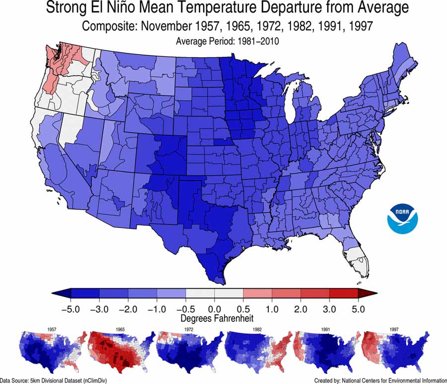
The map above is a composite of how precipitation varied from average during the strong El Niños of 1957–1958, 1965–1966, 1972–1973, 1982–1983, 1991–1992, and 1997–1998. There is a large variability in those six events that makes it difficult to predict the effects at any specific location. The map below is a composite of temperatures for the same periods. Again there is much variability, and you will notice that it is very different from the actual forecast, farther down, for this winter.
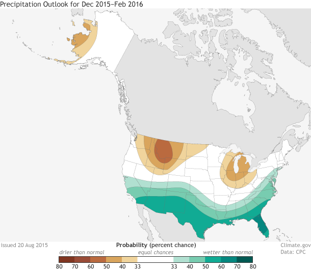
The impacts of El Niño are typically largest in the U.S. during the cool months from October through May. During the winter season, the southern half of the country — from California to the Southern Plains, as well as along the East Coast — typically receives above-average precipitation. Below-average temperatures also often accompany this above-average precipitation in these regions. Across the northern half of the country, the winter season tends to be warmer and drier than average, particularly in the Northwest, Northern Plains, and Ohio Valley.
Below are NOAA’s outlooks for temperature and precipitation for December 2015 through February 2016.


If one checks the maps at the source ( https://www.ncdc.noaa.gov/monitoring-references/dyk/elnino-2015-2016 ) it shows the northern states predominantly warmer than normal for the winter (Dec-Feb) season (with case to case variability, of course) but November is colder than normal as the map in your piece shows. But your statement “you will notice that it is very different from the actual forecast, farther down, for this winter” while true, is somewhat misleading because there is no reason to expect those two maps to be comparable. A better comparison would be with the Nov. outlook at http://www.cpc.ncep.noaa.gov/products/predictions/long_range/lead14/off14_temp.gif which also shows predominantly warm. I don’t know what my former CPC colleagues were thinking on this November outlook, but they do use tools other than just El Nino.
Cheers,
Russell
Nice graphics!
Now we’ll wait and see what happens here in Montana during my February calving season?
We’ew about 60% of normal precip for 2015 here in the Missoula valley.