The Federal Emergency Management Agency is now using the United States National Grid (USNG) as its standard geographic reference system and is encouraging its use among their partners. The agency will use the USNG for deployment and tracking of resources, in their Incident Action Plans, and in NIMS-related programs, guidance, and training. FEMA will encourage all fire departments to use it and the system will be included in the curriculums at the National Fire Academy.
The USNG is a system for describing the location of a place on Earth. You can also use longitude and latitude, or Section, Township, and Range, or one of many other systems. The advantage of USNG is that it is very user friendly. If you know the general location already, for example on a particular wildfire, the location can be communicated with only six digits. It is far easier than using degrees, minutes and seconds, twice — for longitude and then again for latitude.
So with the thought that the wildland fire agencies will eventually begin using the USNG, I starting looking around for inexpensive, user friendly apps for smart phones.
First I looked for an app that could take a photo and automatically superimpose the location on the image in the USNG format. This can be very useful for firefighters to document conditions, conduct investigations, or to send near-real time intelligence to the Incident Command Post or dispatch offices. It could be especially handy for airborne firefighters.
I found that Solocator could meet the criteria, but the standard version, at $0.99, required an additional in-app purchase of $2.99 to enable the use of the USNG, raising the total cost to about $4. Not a huge sum, but $3 more than I expected to spend. If you don’t need the USNG, you can get by for $0.99.
It is a powerful app with many features and is user friendly except for the fact that to get to the settings, you have to swipe left or right from the page you see when you open the program. And there is no indication anywhere in the app, in the description in the app store, or on the developer’s web site that you have to swipe to see the settings.
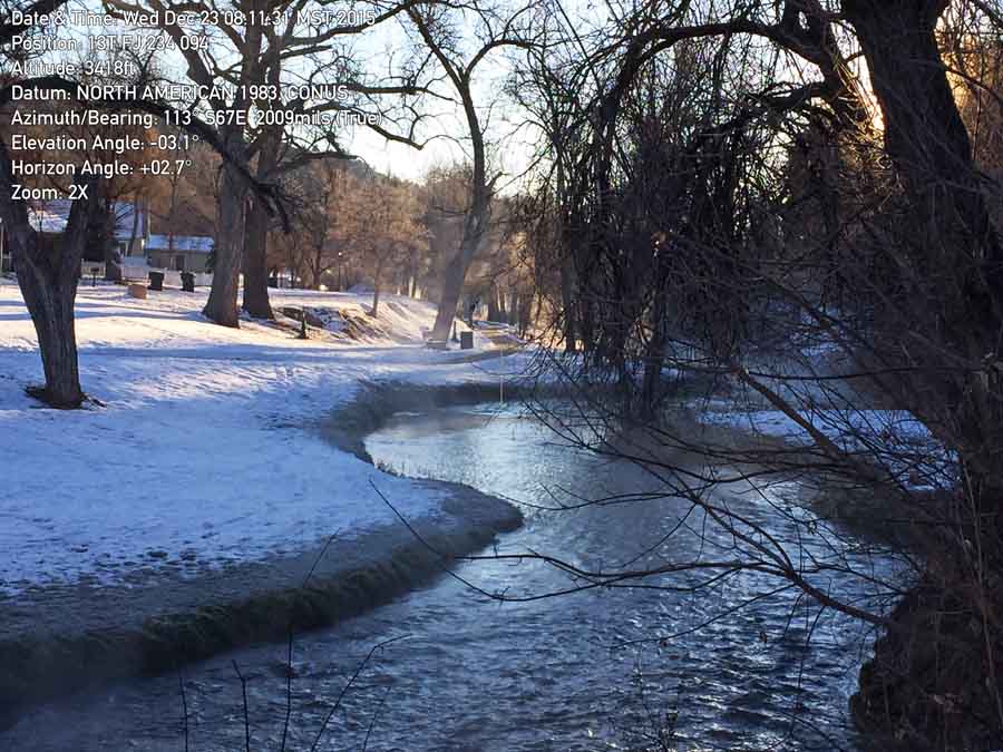
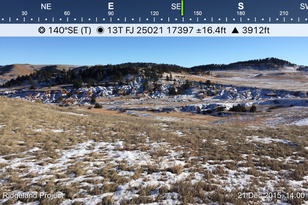
As seen in the image below, you can place on a photo taken with the app the location (using one of many location systems), the direction the camera was facing, elevation, date, and time. The photo below has the location in USNG format, in this case beginning with 13T which is the zone that includes parts of SD, ND, CO, MT, WY, and NE. (National map with grid zones.) You can optionally include a watermark on each photo at the bottom-left, which could be the name of the fire or project, in your choice of three colors for the text. The app produces two images: one with the data and one with no visible data.
The photos you take can be emailed directly from the app.
If a hotshot crew needs air support quickly, they don’t want to fumble around with a cumbersome app — they just want the six digits as quickly as possible.
I looked for a mapping app with:
- GPS,
- maps that can be viewed without internet coverage,
- USNG,
- navigation, and
- the ability to determine the size of a polygon (or fire).
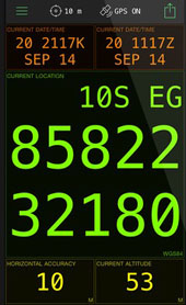
There are a crap ton of apps that are built around GPS, and browsing through them is overwhelming.
I looked at MilGPS which displays your location in HUGE characters. This would be excellent for just getting your coordinates so they can be passed on to someone else. But the app does not have off-line map capability, and I don’t believe it can determine acreage. It is also a little on the pricey side, at $10. I didn’t purchase it.
I downloaded Avenza PDF Maps, which is much cheaper: $0.00. It comes with no maps, but there are hundreds (thousands?) of maps that can be installed, with many of them being free, such as USGS topographical maps and U.S. Forest Service Motor Vehicle Use Maps, all of which can be downloaded directly from the app. (UPDATE 12/24/2015: As Robert pointed out, PDF Maps is only free for personal use. Any commercial, governmental, academic or other non-personal use requires the purchase of a commercial license.)
 I was hoping to find a mapping tool that could determine acreage by automatically recording your location as you walked around a fire, but I don’t believe PDF Maps can do this. It appears that as you walk you have to periodically push a button to find your location and then another button to record that point. The more points you record, the more accurate the result. You can also stand in one place and move the crosshairs over the map and record points to measure an area — a method that would be less accurate than walking the perimeter, but it’s a quick and dirty method of coming up with an acreage figure.
PDF Maps meets all five of the requirements listed above. I have a feeling that many wildland firefighters use this app, and hopefully they can correct me if I’m wrong and provide more details about their experiences.
There are probably many other apps that can perform these functions. There might even be one that can take photos like Solocator AND meet the five mapping requirements.
Let us know in a comment what apps you use for mapping and photo documentation — and what you like and don’t like about them.
UPDATE, December 23, 2015: At Al’s recommendation, we tried out another photography program, Theodolite. The data on the screen does not eat up as much real estate as Solocator, but we could not find a way to put a note or watermark on the photo, such as the name of a fire or project. At iTunes it is priced today at $5.99, which is 40 percent off the regular price. The app can display the location in numerous formats, including USNG with 10, 100, or 1,000 meter precision.

Sir, May I request if we can integrate the company logo within the android app camera captured (geocam especifically) so that it will serve as the copyright.
Thank you.
A simple grid map can be usefull…..with numbers across the top and letters down the side. This is called a bingo grid. There are issues with using a bingo grid as compared to US National Grid (USNG). To use a bingo grid everyone has to have the exact same map. USNG is a standard coordinate system that covers the entire United States. If a person knows their USNG location, this grid location can be given to any organization or person in the US and they can plot that location. You cannot do that with a bingo grid because only the organization that created that grid knows where those locations or “boxes” are specifically located.
I am the developer of the Gmap4 enhanced Google map viewer which has been mentioned in the comments here and is also listed as a USNG viewer by:
http://usngcenter.org/portfolio-item/viewers/
One use for Gmap4 is to help train people that are new to USNG. That is one reason why the coordinates are shown in different colors. Gmap4 also shows people the familiar Google map interface instead of an interface most people have never seen.
Yes, you do have to be online to start Gmap4 (and any other browser app) but if you then pan the map around an ops area the portion of the basemap you display is saved in the browser’s cache and the program will continue to work if your cell phone or tablet goes offline.
Here is a pdf file that shows the Gmap4 features, including geolocation, that support USNG.
Gmap4 can also display user-specified GIS data and overlay it with a USNG grid. It can display *any* public-facing user-specified ArcGIS MapServer layers and/or ArcGIS ImageServer data. The user can define up to a combined total of about 25 GIS basemaps and layers.
Here is a map I made that can display various layers related to wildland fires. Since this is not fire season in the USA, when the map opens it only shows hot spots from the MODIS satellites. Click any symbol and you will see a popup with all the attribute data the GIS server has for the thing that you clicked. Click “About this map” in the upper left corner to see the map legend and get tips for using the map.
A future update will focus on output options. The goal is to let the user produce:
1. GeoPDF files
2. KMZ files that many Garmins can use as basemaps
3. Georeferenced files suitable to be opened in the most popular phone-GPS apps
All of these output options will include a USNG grid.
If anyone has any questions about Gmap4 and/or suggestions for features, here is my contact page:
http://www.mappingsupport.com/p/gmap4_contact.html
Joseph Elfelt
Redmond, WA
Many GPS devices have USNG as a coordinate system. For example my Garmin Etrex has the option of setting coordinates to USNG…it is simple to change.
Paper maps with the USNG grid should still be issued to single resource bosses……not everyone is going to be packing a smart phone. Some fire departments issue an atlas to their initial attack crews that have the USNG grid.
We added information about the photography app recommended by Al, Theodolite, including a photo taken with the app.
avenza pdf maps also has USNG coordinates. Click on the lat long on the bottom of the screen for a list of options.
This year I’m using PDF maps to help with prescribed burn prep in the Southeastern US. It’s been very helpful to locate the over 900 habitat trees we have to rake around in our burn units this year. It’s a good little program for a free app. I haven’t used it on a wildfire yet but I see it being a big help in unfamiliar terrain. Then again, so is a good paper map but those can be harder to acquire than gold on a fire.
Please not that PDFmaps is only free for private recreational users. Any and all government or commercial users must pay them an annual fee starting at $49 per user. Avenza started dunning me by email immediately after I asked tech support a question. Firefighting and other government agencies using their products will presumably have to negotiate bulk license purchases. Are USFS, NPS, CalFire, or other agencies doing this yet?
Forest Service now has an enterprise license for PDF maps.
Do you know when they got it?
It was in October so it wasn’t in place for this past fire season. http://www.reuters.com/article/idUSnCCN3v825C+1c1+MKW20151027
PDF Maps is the ubiquitous app for Wildland Firefighters in our area. I work in both Operations and in Situation and find that PDF Maps is almost always involved in the first hours of rapidly escalating incidents. By the second operational period we provide a 10 minute crash course for those who are new to the app and a dedicated email box to receive data on the fly. Lots of data goes back and forth between PDF Maps and Arc. It is really easy to push data to the line for anybody with a QR reader and the app on their device. Equally as important it is simple for line personnel to push data back to Situation throughout the period.
Recommended app for photos: Theodolite. Two recommended apps are browser apps and will function without internet connectivity if pre-loaded and not closed out in browser: USNGAPP.ORG and GMAP4. USNGAPP.ORG is a simple geo-location app that looks like the Emergency Location Marker (ELM) system and is recommended for use by anyone and can be used by 9-1-1 callers who do not know location, as example. GMAP4 is a google mash map that supports USNG well over many layers to include USGS topos. Finally, for training, new recent presentations are here: https://www.youtube.com/channel/UCi1qd3IYvj–vPf0Kd_K8jw A note about Yarnell; the location was 362 880. This site has the presentation that was given at IAWF Safety Conference in 2015 which describes USNG use in wildfire ops. The origin article, along with many other recent ones are here: https://medium.com/@USNGFlorida
You can do track lines, and polygon areas in Pdfmaps and it can calculate acreage on the go. There is a little wretch looking symbol in the bottom right, it has track and measure distance or acres.
I also highly recommend Nav Camera.
Google Earth understands USNG coordinates. Type “13t fj 25021 17397 usng” into the Search box of Google Earth Pro, and it goes to the spot in the photo.
13t fj 25021 17397 usng
-103.4535932805255,43.49904676147794,0
Great to see this discussion! Checkout review of apps on http://www.usngcenter.org
Thanks Steve. I checked out that list of apps before writing the article, but it was created three years ago. A lot can change in the world of smart phone apps in three years.
Pdf Maps it is great and can use maps created in arc gis
FEMA USAR teams and TEEX Wide Area Search has been using this for awhile
Just a new name for the old MGRS….Military Grid Reference System using 4,6, and 8 digit grid coordinates
New names for something old…..50 plus years old!!!!
Bill, I’ve used PDF maps to help determine average. Using it and my Garmin simultaneously produced near identical (within two-tenths) acerages of a 452 acre fire. If I remember right, I just hit record then stop when finished. The added bonus of PDF Maps is being able to download any PDF, including maps, making it a good single point to compile information.
I’m also working on our local unit to produce IAP maps with a simple grid, alphabetical designation on one axis, numerical on the other. The folks up in Alberta turned me on to it. From a safety perspective, I think it could be helpful in the event of an emergency as long as dispatch, ops, plans, etc all had a copy. In thinking about Yarnell, if Granite Mountain could have told Air Attack “We’re deploying in Zulu 6 (as an example)” it could narrow the search area down significantly without having to punch GPS coordinates in. The grid will be 3 “resolutions” so that on small, medium and large fires, the grid is still useful. The Canadians use square kilometers.
Thanks for checking out the apps and updating all of us.
Yarnell was 362 880. Before instituting non-interoperable grid labels, please read this: http://www.ffca.org/files/pdf%20files/USNG%20National%20Grid%20Letter.pdf Florida Forest Service is moving to USNG. Once a team is in trouble, they need SAR. The land SAR coordinate system since 2011 is: USNG. http://www.epcupdates.org/2012/03/nsarc-designates-usng-as-land-sar.html The recommendation would be to use the standard, not create a new one. Finally, Yarnell article: https://medium.com/@USNGFlorida/additional-lessons-that-could-be-learned-regarding-yarnell-hill-fire-7cfc3d545c94#.gvddc3l7v
Hi, i recomended Geocam and Geocam Ar Pro. Very useful in many incidents types.
Also used Locus Map Pro
Take a look at Tactical nav app