The University of Wyoming paper covers basic facts about fire, weather, intensity, severity, prescribed burning, as well as fire effects and interactions with soils, plants, livestock, wildlife, and bark beetle outbreaks. The document is 16 pages long with an additional 8 pages of references and a glossary. It was written by Derek Scasta, Assistant Professor and Extension Rangeland Specialist.
A couple of items attracted my attention. One is the graphic at the top of this article, the mean fire return interval for Wyoming. If you’re familiar with the geography of an area, data like this can absorb your interest for a while. The map appears to be a section taken out of the whole country map.
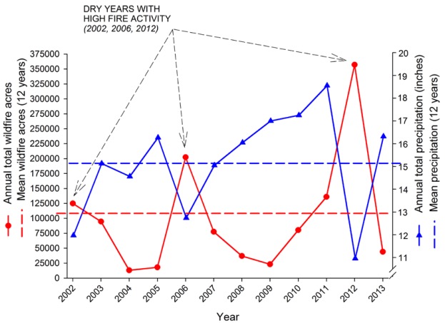
Another topic covered in the publication is the relationship between precipitation and acres burned.
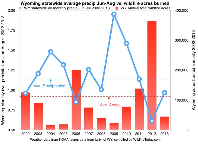
The chart above from the paper uses the total Wyoming statewide annual precipitation compared with the total number of acres burned in wildfires each year. We have been thinking that the weather in the summer has a greater effect on acres burned than weather throughout the year. Those weather factors include temperature, relative humidity, wind, and precipitation, and a few others used by the National Fire Danger Rating System. It’s beyond our capacity to analyze all of those, unless we use an index that takes multiple parameters into account, such as the Burning Index or the Energy Release Component.
But what we did (immediately above) was to take one weather parameter from the summer and plotted it on a chart similar to the UofW chart– average monthly precipitation each year for June, July, and August. The weather data came from NOAA, and the acres burned was extracted from the University of Wyoming chart.
Included among the disclaimers is that average precipitation across the state does not apply to every square mile. Thunderstorms in the summer could be hammering one area, while a major fire is burning somewhere else. And, using only precipitation does not take into account temperature, relative humidity, and wind, which are all very important.
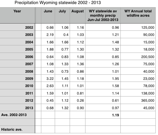
If anyone is interested in analyzing the Wyoming fire occurrence data using another weather factor or NFDRS Index (from the summer months), below are the numbers I used. Or, if you’d like to look at another state or geographic area, that would be fine. It’s important to analyze the acres burned and the weather observations for a large area in order get a sample of sufficient size to make it statistically significant. For example, use 15 to 20 years of information from a large national forest with multiple weather stations to reduce the data-skewing impact of a gully-washer thunderstorm at one location.


Great article. Thanks Bill
You’re very welcome.