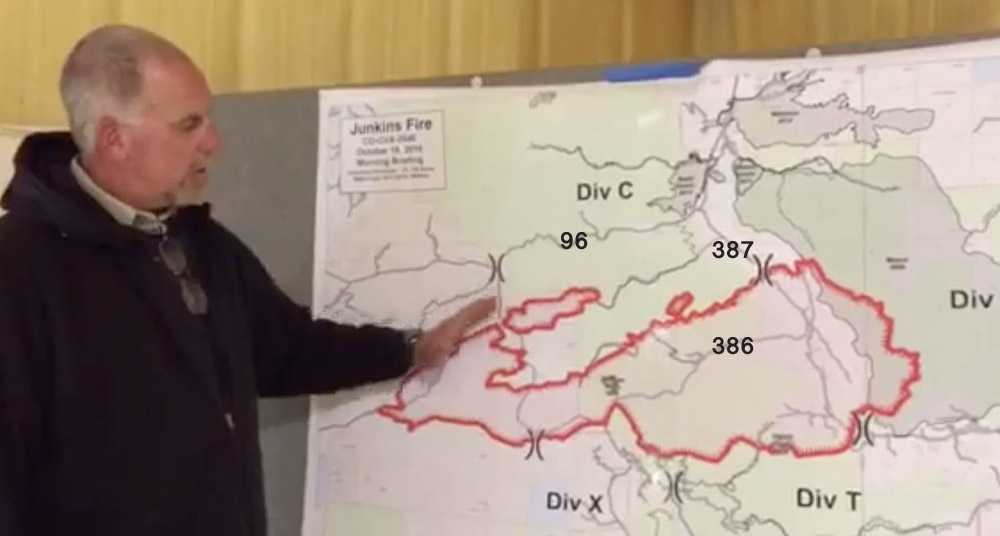
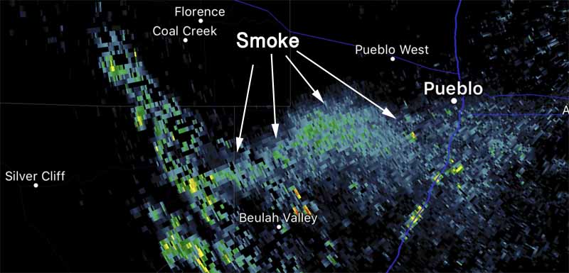
Above: Map of the Junkins Fire October 18.
(Click HERE to view our most recent article about the Junkins Fire.)
(UPDATED at 4:31 p.m. MDT October 19, 2016)
The Junkins fire west of Pueblo, Colorado, according to mapping on October 18, has burned 16,832 acres. Fire officials said Wednesday a shortage of firefighting resources is slowing the construction of firelines and the containment of the fire. In fact, they are saying firefighters have not contained any of the fire.
It started during strong winds on October 17 when a power line failed and hit a barbed wire fence.
A Type 1 Incident Management Team from the Great Basis assumed command of the fire on Wednesday.
ALERT: Incredible photos from @PuebloWestFire Brad Davidson assigned to the #JunkinsFire
What we know: https://t.co/C8kQuuU8Bj #wildfire pic.twitter.com/mmddMKYQPG— Matt Kroschel (@Matt_Kroschel) October 19, 2016
DFPC and DHSEM staff attend the #JunkinsFire EOC briefing and will continue to support the fire. #COFire pic.twitter.com/JUsZuyLGIi
— COFirePrev&Control (@COStateFire) October 19, 2016
****
(UPDATE at 1:56 p.m. MDT October 18, 2016)
The Junkins Fire 21 air miles west of Pueblo, Colorado had burned 15,751 acres when mapped by one of the state’s Multi-Mission Aircraft at 7 p.m. on Monday. The fire continued to spread after that flight, particularly on the south and the northeast sides, and an updated acreage should be available after it is mapped again this morning.
Fire perimeter map 10/18/16 #JunkinsFire pic.twitter.com/8k5XaEmJ68
— @JunkinsFire (@junkinsfire) October 18, 2016
Much of the activity of the firefighters has been defensive, staging firefighting resources well outside the fire perimeter to protect structures. Tuesday afternoon should bring winds out of the southwest and east, so a priority will be the structures along Highway 96.
The Tuesday forecast for the fire area also includes temperatures in the low 60’s, relative humidity in the low 20’s, and partly cloudy skies.

Some of the geographic Divisions are larger than desired due to a shortage of resources, according to Planning Operations Section Chief Dan Dallas.
East of County Road 387 the fire has burned into the large scar from the 2005 Mason Fire, slowing the spread. Monday night one of the most active sections of the fire was on the northeast side, between County Road 387 and the fire scar.
The county Sheriff said another residence burned Monday night, bringing the total up to two homes and 5 outbuildings that have burned.
Tuesday morning 114 personnel were assigned to the fire. Aircraft being used include 2 large air tankers, 4 single engine air tankers, 2 large helitankers, 2 national guard helicopters, a lead plane, and the Multi-Mission Aircraft. Operations Section Chief Dallas said he expected the aircraft will be used more heavily today than yesterday.
****
(UPDATED at 6:30 p.m. MDT October 17, 2017)
The Junkins Fire about 25 miles west of Pueblo, Colorado has burned about 13,300 acres according to a 3:30 p.m. update from fire officials. Approximately 80 personnel are on scene. One residence and three outbuildings have been destroyed. Part of the fire has spread into a an old burn from 2005, which slowed the progress of the fire in that area.
A Type 3 Incident Management Team is running the fire now, but a Type 1 Team has been ordered.
****
(UPDATED at 12:34 p.m. MDT October 17, 2016)
A fire that was reported at 3:40 a.m. MDT on Monday has already burned thousands of acres and forced evacuations about 29 miles west of Pueblo, Colorado. The Westcliffe Daily Record reported at 10:46 that the Junkins Fire has blackened approximately 11,000 acres. It is burning in the general vicinity of McKenzie Junction, the intersection of Highways 165 and 96, eight miles southwest of Wetmore.


Fire officials did find powerline down near start of #JunkinsFire but CANNOT confirm that the powerline is the cause. Too early- @FOX21News
— Joe Cole (@JoeColeFOX21) October 17, 2016
The fire has already crossed Highway 165 and it is expected to cross Highway 96, according to Cindy Howard with the Custer County Office of Emergency Management. Residents along 165 from 96 to mile marker 11 should evacuate she said, and the evacuation area is expanding.
This is how alarming the Custer County #JunkinsFire looked from ~30k feet earlier this morning pic.twitter.com/Xcz5Z8Q9Vi
— Brittany Shoot (@brittanyshoot) October 17, 2016
The Colorado Department of Transportation reports the fire has closed highway 96 in between Wetmore and Westcliffe. Highway 165 is also closed at McKenzie Junction.
The area is under a Red Flag Warning today for very strong winds. The forecast for the fire area on Monday predicts sustained west winds at 25 to 38 mph with gusts from 36 to 57 mph along with relative humidity in the teens.


Shortage of resources. To bad there are 19 Hotshot Crews sitting available in California. Ridiculous north and south ops.
I was at my cabin in Custer County this weekend at 8700 feet. I had wind gusts of 70-90 mph starting about midnight on Saturday night and through the day Sunday. Did that take down a powerline? The Jamestown fire a few years ago in Boulder County started that way…during a Chinook. My recollection was that the fire ran 7 miles in one day.
My prayers go out to the firefighters and all the people Jenkins pass fires.. May God bless you and keep you safe