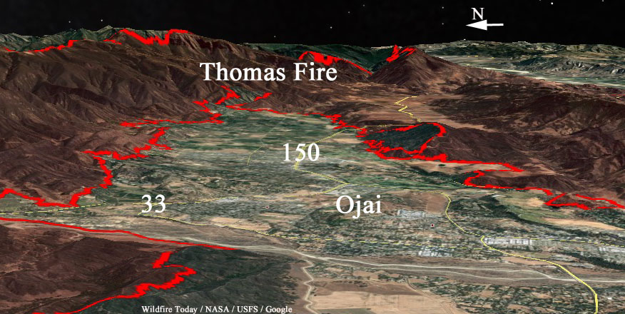
Above: The red line was the perimeter of the Thomas Fire at 9:30 p.m. PST December 8. The red dots represent heat detected by a satellite at 12:45 p.m. PST December 9, 2017.
(UPDATED at 6:52 p.m. PST December 9, 2017)
The 155,000-acre Thomas Fire has moved into Santa Barbara County near Divide Peak. Late Saturday afternoon the Incident Management Team reported that 460 structures have been destroyed in the city of Ventura and another 140 in the rest of Ventura County.
Most of the growth of the fire Friday night and Saturday morning was on the west side. The east side northwest of Fillmore was also active and air tankers and helicopters were used with good results there Saturday.
As the fire moves closer to Carpinteria 50 engines have been staged in the city and preparations are being made to protect structures and construct firelines. The fire is about 5 miles northeast of the intersection of Highways 1 and 150 on the east side of the city.
An unmanned aerial aircraft is being used to provide a live video feed to firefighters.
About 4,400 personnel are assigned to the fire and a large order for additional resources was placed today. The estimated costs to date are $25 million.
****
(UPDATED at 5:45 a.m. PST December 9, 2017)
The Incident Management Team reports that the Thomas Fire has destroyed 476 structures and burned 143,000 acres. Some mandatory evacuation orders have been lifted but many are still in place for some locations in the Ventura and Ojai areas.
On Friday the fire was very active across most of the north side, west of Lake Casitas, and northwest of Fillmore. It is expected to spread towards Santa Barbara County, Sespe Wilderness and the Sespe Condor Sanctuary.
Temporary residential access will be permitted on Saturday 12/9/17 and Sunday 12/10/17 during the hours of 9:00 am and 4:00 pm for residents who live in the areas affected by the Thomas Fire. The access will be by escort only. A check-in tent will be set up in the parking lot of Temple Beth Torah located at 7620 Foothill Road. Residents must be able to show proof of residency (Driver’s License, Utility Bill, etc.) to be permitted to enter. Entry will be limited to 2 persons per household. Personal vehicles will not be allowed into the area. Residents will be driven to their home and allowed a 15-minute period of time to get personal necessities (clothing, medication, etc.). For safety purposes, access will not be permitted to home sites which have been destroyed or sustained damage that poses a safety risk.
****
(UPDATED at 5:24 p.m. PST December 8, 2017)
The Ventura County Fire Department has revised the number structures destroyed in the Thomas Fire from 91 to 401.
Friday afternoon the fire was very active on the north side — north of Wheeler Springs, and on the east side northwest of Fillmore. It was fairly quiet around Ojai with the exception of a controlled burnout to help tie in some fireline south of the south end of Boardman Road.
(All articles on Wildfire Today about the Thomas Fire are tagged “Thomas Fire”.)
The 747 airtanker that dropped about 57,000 gallons of fire retardant on the Thomas Fire today is under contract to CAL FIRE.
Big, Big Bird: Tanker-944 (747) at work on the #ThomasFire https://t.co/2cyAhzgwZI pic.twitter.com/jLIW9sNN7f
— USFS Fire-California (@R5_Fire_News) December 8, 2017
****
(Originally published at 10:40 a.m. December 8, 2017)
The 132,000-acre Thomas Fire is far from being contained. Over the last two days it has been spreading to the west, almost enveloping the city of Ojai and growing closer to Carpinteria as it burns near the Pacific Ocean.

(All articles about the Thomas Fire on Wildfire Today are tagged “Thomas Fire”.)
These numbers will no doubt change in the next week or so, but officials report that 73 residential, 3 commercial and 15 outbuildings have been destroyed, mostly in the Ventura area.
This huge “megafire” is being fought with 471 engines, 28 hand crews, 12 helicopters, 26 dozers, and 7 water tenders, for a total of 2,509 personnel.


3D renditions such as this help when trying to visualize the relationship between the fire and the topography, especially in these mountainous regions. Thanks.