Above: The Thomas Fire as seen from Sisar Peak east of Ojai at 9:07 a.m. PST December 10, 2017.
(UPDATED at 9:58 p.m. PST December 10, 2017)
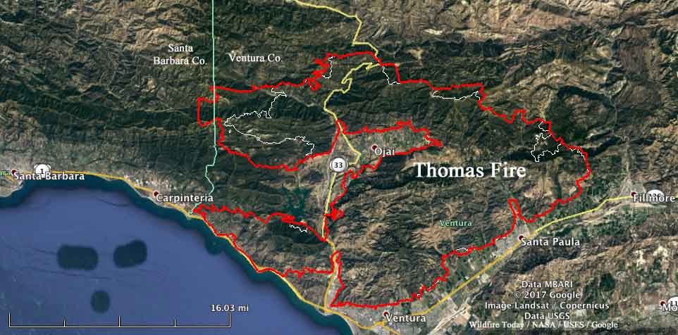
The Thomas Fire has spread well into Santa Barbara County, and Sunday afternoon was on the slopes north of Carpinteria, California. The strong northeast Santa Ana wind slowed, as has the fire growth, but the vegetation is so dry that a moderate wind can still keep it moving at a persistent pace
(All articles on Wildfire Today about the Thomas Fire are tagged “Thomas Fire”.)
Sunday evening the U.S. Forest Service reported the fire has burned 230,000 acres. If this is accurate it puts it at number 5, near the top of the list of the largest fires in the recorded history of California.
The forecast calls for wind on the slopes above Carpinteria Sunday night to be from the northeast at 10 mph, variable directions on Monday, and then Monday night to again be from the northeast but stronger, 15 mph with gusts to 23. The relative humidity will remain in the teens night and day through Tuesday. This could lead to active fire behavior throughout that period.
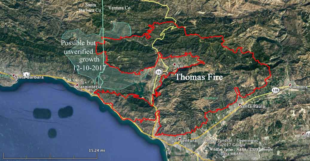
Using heat sensor data from a satellite, we mapped the additional acres that burned on the west side of the fire Saturday night and early Sunday morning. It is shown in blue on the map below, and this freshly burned area covers about 40,000 acres. The data is not verified, since at times the heat sensor was overwhelmed by hot particulate matter in the smoke plume outside the actual fire perimeter, so this may change after more accurate information is available from an overnight fixed wing aircraft mapping flight.

****
(UPDATED at 4:55 p.m. PST December 12, 2017)
At a town hall meeting about the Thomas Fire at San Marcos High School today, officials provided updated information.
The fire made a major run during much of the day on Sunday, adding an estimated 50,000 acres which could bring the total size up to around 225,000 acres by the end of the day. This would make it the 5th largest in recorded history of the state. These numbers are subject to verification by aerial mapping scheduled for Sunday night.

An additional 100 fire engines were ordered for the Santa Barbara area.
The live broadcast was hosted by VCFD_PIO on Periscope.
By the numbers:
Structures Threatened: 15,000
Structures Destroyed: 754
Structures Damaged: 162
Engines: 611
Water Tenders: 31
Helicopters: 30
Hand Crews: 55
Dozers: 51
Total Personnel: 4435
****
(Updated at 9:51 a.m. PST December 10, 2017)
New evacuation orders have been issued for areas in Santa Barbara County as the Thomas Fire aggressively spreads further west. Saturday afternoon it moved into the county north of Carpinteria putting up massive convection columns of smoke Saturday night and Sunday morning as strong winds and very low humidity persisted throughout the night.
The fire continues to burn actively to the north, east, and west threatening structures in parts of the cities of Ventura, Ojai, Casitas Springs, Santa Paula, Carpinteria, Fillmore and the unincorporated areas of Ventura County and Matilija Canyon. It is expected to spread towards Sespe Wilderness and the Sespe Condor Sanctuary.
CAL FIRE reported Sunday morning that the Thomas Fire has burned 173,000 acres and destroyed 537 structures, damaging 118 others.

The latest information about evacuations is at the Santa Barbara County website, but generally, as of 7 a.m. Sunday, the new area is “north of Highway 192, E. Valley Road, east of Buena Vista Drive, to include the 900 block of Park Lane, is a mandatory evacuation zone. Everything south of Highway 192, E. Valley Road, east of San Ysidro, is under a voluntary warning order.” (map) An evacuation shelter has been established at the UCSB Recreational Center, 516 Ocean Road, Santa Barbara.
The weather continues to be a challenge for firefighters. The Sunday forecast call for a Red Flag Warning including winds northeast at 20 to 30 mph with gusts up to 45 mph. And on Monday, 15 to 20 mph with gusts to 35 mph.

#ThomasFire – FF’s knock down flames as they advance on a home atop Shepherd Mesa Road in Carpinteria at 6 am Sunday morning. pic.twitter.com/3M9rO7cYCd
— SBCFireInfo (@EliasonMike) December 10, 2017
#ThomasFire– A home burns early Sunday morning off Gobernador Canyon Road in Carpinteria. pic.twitter.com/OoIp3yc1sE
— SBCFireInfo (@EliasonMike) December 10, 2017


