Above: CAL OES Strike Team 2870C, Strike Team Leader, and #ALCOFire Battalion Chief R. Oatis at the Pawnee Fire in Lake County. Via Alameda County Fire, June 24, 2018.
(Updated at 5:56 a.m. PDT June 25, 2018)
A wildfire first reported Saturday afternoon north of the city of Clearlake in Lake County, California grew substantially Sunday forcing hundreds of residents to evacuate.
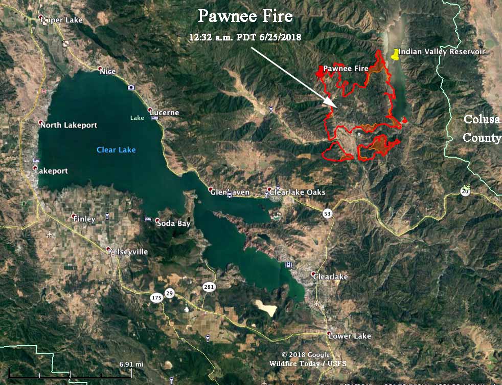
CAL FIRE reported at 6:31 p.m. PDT on Sunday that the Pawnee Fire had destroyed 12 structures, with another 600 threatened. The Lake County Sheriff’s Office issued mandatory evacuation notices for Spring Valley and areas north of Highway 20. A mapping flight at 12:32 a.m. Monday determined that it had burned 8,502 acres.
The fire burned very actively throughout the day Sunday in the Spring Valley area northeast of Clearlake Oaks in Lake County. It was driven Sunday by low relative humidity, strong winds, and above normal temperatures. Sunday afternoon a weather station at High Glade Lookout northwest of the fire recorded 12 to 18 mph winds out of the south with gusts at 20 to 30 mph.

Data from the mapping flight Sunday night showed that the fire was six miles north of the city of Clearlake and three miles northeast of Clearlake Oaks. However the fire could have grown substantially since then.
The forecast for the fire area on Monday is not expected to bring extreme fire weather. The prediction is for temperatures in the high 80s, relative humidity in the low 20s, and 3 to 6 mph winds out of the north in the morning switching to come out of the south and southwest in the afternoon. The changing wind direction could present problems for firefighters.
Several other fires are burning in Northern California, including one 21 miles southeast of the Pawnee Fire just southwest of Hershey, another fire 21 miles northeast of Red Bluff, and a third, 8 miles southwest of Redding.
We will update this article and the map as conditions change.
At least 7,700 acres burned in the #PawneeFire in California – the Lake County Sherriff says this is unprecedented. 10 structures burned, 600 at risk. ?:Lake County, California via Craig Philpott / @Storyful pic.twitter.com/PjNa0vsE36
— Ginger Zee (@Ginger_Zee) June 25, 2018

