(Originally published at 9:10 a.m. PDT July 28, 2018)

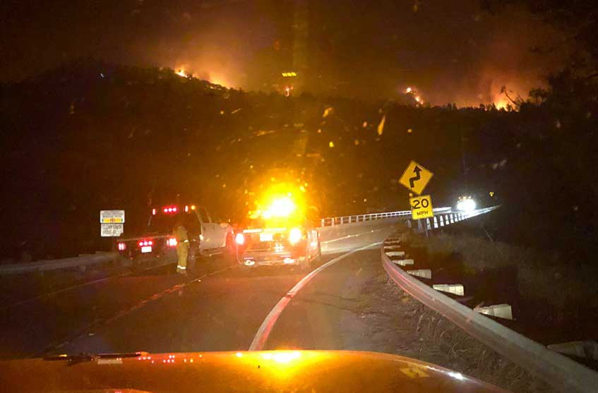
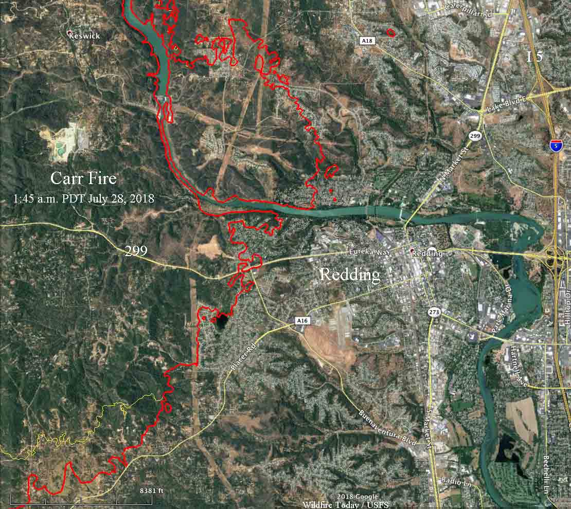
Firefighters on Friday were able to minimize any additional growth of the Carr Fire into Redding but the fire spread significantly on the north and sides. Thursday night CAL FIRE reported the fire had burned 28,000 acres. A 1:45 a.m. mapping flight on Saturday showed it had expanded to over 80,000 acres.
To see all articles about the Carr Fire on Wildfire today including the most current, click here.
Early Saturday morning the fire was very active two to five miles south of Highway 299 burning toward Placer Road near Igo, and on the north side of 299 it had grown five miles north of French Gulch.

Mandatory evacuations affecting 37,000 people and road closures are in effect for numerous locations around Redding.
Two firefighters were killed in the fire. Friday afternoon the Redding Fire Department confirmed that Inspector Jeremy Stoke perished. A bulldozer operator has not yet been identified.
A spokesperson for Mercy Medical Center in Redding, Mike Mangas, said eight people, including three firefighters, were treated for injuries. All were expected to survive.

CAL FIRE reports that 500 structures have been destroyed, but has not broken them down by residences and outbuildings. On Friday an Associated Press reporter counted at least 125 burned homes. Typically on fires like this about 60 to 80 percent of “structures” destroyed are sheds, detached garages, or similar outbuildings.
Below is an excerpt from an AP article:
Located on the western side of Redding, KRCR-TV was forced to go off the air and evacuate their studio in the middle of a Thursday night broadcast. As the fire advanced, a high school that was used to shelter evacuees was suddenly in danger of being in the path of the flames, and evacuees had to move again to Shasta College, according to NBC News.
“When it hit, people were really scrambling,” Cal Fire spokesman Scott McLean told the AP. “There was not much of a warning.”
The fire also reportedly burned structures in Shasta, located 10 miles west of Redding, and in Keswick. Early Friday morning, the entire town of Shasta Lake, population 10,000 was ordered to evacuate, the Redding Record Searchlight reported.
The weather forecast for the south part of the Carr Fire near Igo for Saturday calls for a high of 110 degrees, 11 percent relative humidity, and variable winds at 5 to 10 mph gusting up to 13. The conditions should remain about the same through Friday of next week, but with decreasing winds. High temperatures will be above 100 each day.

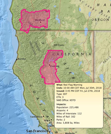
The Red Flag Warning that was in effect for the Redding area on Friday is still in effect Saturday and is due to expire at 10 a.m. Monday.


I have a cousin that lives in Redding but do not have his address. He is very involved in track and many aspects. If any one know of Bruce Makinson I would appreciate any info. He is in his early 70’s
Our family is eight miles out on Bowman Road cottonwood Is fire going towards Platina? We live in Branson Mo.
My children are camping up in Scott Mountain Summit. Does anyone know if fires are moving in that direction? And what’s a way out to go South since they usually go through Redding?
Is the fire approaching Cottonwood tonight?
Does anyone know if the fire has reached small Farms Road in Igo I live at the very end of small farms I’m out of state currently on my way home now
I have not heard from my son, he is off Lake Blvd and Santa Rosa? also my parents use to live in river ridge off quartz hill and I am concerned with the neighbor of theres that are there. on Diamond Bar Ct. any information would be greatly appreciated
How is Magnums way
magnums is good fire came about a half mile away. my family has a house there near magnums and santa rosa every things good!
Once again we see CDF heavy equipment operators LOST, what is going wrong CDF is it time to stand down and look at safety issues. Firefighting has always been dangerous that’s a given. But two tractor operators in a row is not just a normal pattern for anyone.
John H. Moore Capt. Crew-1 ECHS USFS Ret. 1966
Not that it lessens the impact of a loss of life, but this fatality was a private contractor. Not known yet the reasons and actions that impacted decisions made. RIP
I was planning months ago to drive up to Shingletown to visit grandparents. Can’t get a hold of them, because they never pick up their phone. Is it ashy their and does anyone know about air quality?
We’re old and don’t make it to the phone a lot. So if no one answers hang up and ring again.. they probably didn’t hear it till it was almost done ringing and then didn’t get to it till after you hung up.
Anyone know if the houses on beacon Street are ok I have family that live there and had to evacuate and they don’t know if their house is ok?
Can somebody please tell me, is Shingletown okay? I have family there and I can’t get hold of them. My heart goes out to ALL affected by this fire. God be with you! ??
Shingletown is about 25 air miles east of the fire.
Shingletown is OK. Shingletown is about 30 miles away from the fire or so, and is not at this time in danger from the fire.
Shingletown has not been affected
Hi, Shingletown is about 45 minutes and 30 plus miles to the east of Redding. I understand it looks like Shingletown is in direct path of the Carr fire, but this fire is not going to threaten Shingletown.
Yes shingletown is ok. I live 5 miles below the Shingletown store! The fire is far from us!
Shingletown is fine I live in Redding my in laws live there it’s ok
Shingletown is fine. My dad is there. Just talked to him
Shingletown is fine. We have a house there and were on-sight these past few days. It’s on the otherside of Redding from where the fire is currently burning.
I’m in cottonwood, Shingletown is not in danger. Fire is not moving in that direction.
Shingletown is still safe.
Shingletown is far away from the fire. This fire is staying mostly on the WEST/NORTHWESTERN side of the 5 Freeway. Shingletown is about 25 miles to the East – the opposite direction of this blaze. Your family is safe where they are. Everything EAST of the 5 Freeway is okay at this point.
My sister lives off Gas Point rd in Happy Valley. Is the fire moving in that direction?
My family is in Happy Valley (China gulch rd.) and have been ok so far.
family off gas point rd in Cottonwood. last i heard they were getting pretty heavy ash/branding. they felt ok, i told them keep an eye out for new starts/spots. super dry, red flag day.