Ukrainian Prime Minister says wildfire near Chernobyl contained, but…

Map of fire near Chernobyl
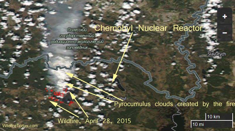
Map of the fire near Chernobyl 4-28-2015. This photo was captured later in the day than the one we posted previously. It shows pyrocumulus clouds created by the fire, indicating extreme fire behavior, rather than smoke from a “contained” fire. The red dots represent heat detected by a satellite. NASA photo.

The Prime Minister of the Ukraine was quoted as saying the large fire east of the melted-down and abandoned Chernobyl Nuclear Reactor is “localized and contained. Radiation levels are normal”, he told a government meeting on April 29.

On April 28 we published a photo showing the location of the fire about 10 miles (16 kilometers) west of Chernobyl. It included smoke being pushed to the north and one cloud that could have been a pyrocumulus created by the fire. Today, April 29, we found a satellite photo (above) that was taken later in the day on April 28, that showed massive pyrocumulus clouds, which would indicate extreme fire behavior from a very active fire that was far from being contained.

The blaze, which we estimate to be at least 9,000 acres, is burning in an area contaminated with radioactive particles which could become airborne during a wildfire. It is burning within the Chernobyl Exclusion Zone, also known as the 30 Kilometer Zone, or the Chernobyl Zone of Alienation.

The video below was uploaded April 29, 2015. Here is the description:

Fire engulfed a large sector of woods in the exclusion zone around the destroyed Chernobyl nuclear power plant on Tuesday.

Other articles on Wildfire Today tagged Chernobyl.

Wildfire burns within 10 miles of Chernobyl nuclear reactor

Map of fire near Chernobyl
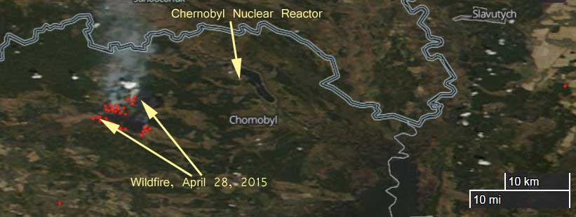
Map of fire near Chernobyl 4-28-2015. The red dots represent heat detected by a satellite. NASA image. (click to enlarge)

A wildfire is burning within about 10 miles (16 kilometers) of the Chernobyl nuclear plant that melted down in the Ukraine in 1986. According to NASA imagery, the fire appears to be well within the Chernobyl Exclusion Zone, also known as the 30 Kilometer Zone, or the Chernobyl Zone of Alienation. The area is still heavily contaminated with nuclear radiation and for years officials have been contemplating how to mitigate the potential for a fire in the dead forest, killed by the melt-down, which would release radioactive particles into the smoke and be carried downwind, perhaps for very long distances.

An article at RTnews reports that the Ukraine Interior Minister Arsen Avakov said the fire has burned about 400 hectares (988 acres).

Our extremely rough estimate of the size of the fire based on the satellite imagery is that it has burned about 9,000 acres. When the photo was taken the smoke was being pushed north, at about 90 degrees to the path that would take it closer to the disabled nuclear plant, east of the fire.

Excerpts from the article:

“The forest fire situation around the Chernobyl power plant has worsened,” a statement on Avakov’s Facebook page says.

“The forest fire is heading in the direction of Chernobyl’s installations. Treetop flames and strong gusts of wind have created a real danger of the fire spreading to an area within 20 kilometers of the power plant.

Police and National Guard units are on high alert. Ukraine’s Prime Minister personally went to the affected area to oversee the firefighting. He says the situation is under control, “but this is the biggest fire since 1992.”

The potential danger in this fire comes from the radioactive contaminants the burning plants have absorbed, ecologist Dmitry Shevchenko told RT. “A lot of radionuclides have accumulated in the soil, the trees and other plants. And of course when something like a fire happens, together with the smoke, the radionuclides can travel great distances.”

We have written numerous times about the challenges presented by the contaminated vegetation near Chernobyl. Articles tagged Chernobyl.

Additional lessons that could be learned regarding the Yarnell Hill Fire

One of the presentations last week at the International Association of Wildland Fire conference, “Managing Fire, Understanding Ourselves”, concerned additional lessons that could be learned from the 19 fatalities on the 2013 Yarnell Hill Fire. Specifically, use of the term “MAYDAY” and the National Grid mapping system.

Most of the following presentation was prepared by Al Studt, of Cape Canaveral Fire and Rescue. It was presented at the conference by wildland fire consultant Richard McCrea. It is used here with their permission.

To  view the slides, click the triangular play button and allow them to automatically advance every 10 seconds, or manually click the right arrow when you want to view the next slide.

Authorities in Texas concerned about exploding targets

An article in the Tyler Morning Telegraph explains how law enforcement authorities in Texas are concerned about the spreading use of exploding targets in the state. It also reports that an eight-year old boy was killed in Oklahoma by shrapnel from an exploding target.

Below is an excerpt:

Reports of mysterious, loud booming explosions in rural areas across East Texas have sheriff deputies and fire departments searching their jurisdictions for the cause.

Although there typically is no lingering smoke, fire or other signs to point authorities to locate the source, Smith County Sheriff’s Lt. Gary Middleton and other law enforcement officials believe many of the explosive sounds are the result of people using shooting targets designed to explode when hit.

“A lot of these calls are due to people shooting (various brands of explosive targets) which are perfectly legal across much of the nation at this time,” Middleton said.

The targets are sold as kits containing two chemical components — such as ammonium nitrate and aluminum powder — that separately are not explosive, but when mixed together are primed for eruption. The target kits are available to the public in most gun stores and large sporting goods retailers.

Manufacturers of the product say the products are safe when used as intended, but law enforcement officials warn improper use could result in serious injury. In several instances across the nation, the shrapnel from blasts resulted in serious injuries and death.

Earlier this year, an 8-year-old boy in Oklahoma was killed when an outdoor stove stuffed with the material was shot and exploded, sending shrapnel into the child. The child’s adult relative has been charged with manslaughter in the death…

Military training starts fire in northern Michigan

Pyrotechnics used by the military during training in northern Michigan (map) started a fire that burned about 700 acres Saturday, according to military officials on the scene.

Below is an excerpt from 9&10News:

…The fire tore through parts of Camp Grayling  in Crawford County around 2:00 yesterday afternoon and burned an area North of Kyle Lake Road.

New information now suggests that a Marine infantry battalion training on site employed pyrotechnics and signal flares and inadvertently started the fire.

A senior Camp Grayling official tells Northern Michigan’s News Leader that, after realizing the fire was too large to effectively extinguish, crews made the decision to keep the flames contained to a well-defined area–and then treated it as an unscheduled controlled burn, making ‘the best of a bad situation’.

Ninth grader invents a wildfire warning system

The video shows Sahar Khashayar demonstrating a wildfire detector on the Tonight Show.

The Orange County Register interviewed Ms. Khashayar after she became a finalist for the 2014 Broadcom MASTERS competition. Here is an excerpt from the interview:

****

“Q. Tell me about your wildfire early warning system – how does it work?

A. Basically what I did was I wanted to create something that 1) was cheaper than most fire detecting systems, 2) could detect multiple types of fires and not just smoke and 3) would be able to send a message to someone, so that if the alarm went off and the person wasn’t there, they would still know that it was happening.

Most fire detection systems, like the one we have right now, can cost $200 or more. My entire setup is about $56.

To solve the problem of different types of fires, we have three different sensors here. So there’s a gas sensor to detect carbon monoxide, carbon dioxide or propane gas and all kinds of gases. There’s an infrared sensor, which detects light waves; and a temperature sensor, which is for the ambient temperature for the area it’s in. They’re all connected to a microprocessor, and you can hook it up to your own laptop so it can read the different input from the different sensors.

Right now it’s connected to Bluetooth, which will send a message to your phone if it detects a fire. If this device actually becomes implemented somewhere, we would probably use a GSM, which is basically Wi-Fi, so that it can send a text since Bluetooth has a shorter range.

Q. Where did you get the inspiration to create this device?

A. There have been a lot of fires recently – and not just in California, but all over the United States – and it’s costing a lot of money and even lives. So it’s becoming a huge problem for the environment, for the economy and people in general. It was a problem that needed to be solved.”

UPDATE: June 5, 2015:

The  Orange County Register has an update on Ms. Khashayar and her device.