Arizona state official says Granite Mountain Hotshots made mistakes

Granite Mountain Hotshots

(UPDATE at 12:20 p.m. MDT, August 1, 2013)

Arizona Governor Jan Brewer said Wednesday that Arizona State Forestry Division Deputy Director Jerry Payne actually did make the statements about the cause of the fatalities that John Dougherty, of Investigative Media, reported. She said this, in spite of the vigorous denials made earlier by Payne and the department’s spokesman, Jim Paxon. Investigative Media has more details on these developments.

****

(UPDATE at 12:15 a.m. MDT, July 31, 2013)

The Arizona State Forestry Division has issued an apology for the “unauthorized opinions” expressed by Deputy Director Jerry Payne.

****

(Originally published at 12:42 p.m. MDT, July 30, 2013)

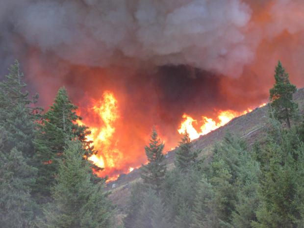
An official with the Arizona State Forestry Division told a reporter Monday that the Granite Mountain Hotshots made mistakes and violated procedures that led to the deaths of 19 members of their crew on the Yarnell Hill Fire on June 30.

John Dougherty, of Investigative Media, recently interviewed Jerry Payne, a deputy director of the Arizona State Forestry Division, who told him that Eric Marsh, the Superintendent of the hotshot crew, was serving as Division Supervisor the day of the fatal accident. One of the captains on the crew took Mr. Marsh’s place and the hotshots were assigned to Marsh’s Division.

Mr. Dougherty wrote that the deputy director told him that while the hotshot crew was hiking from the black, or burned area of the fire toward the ranch house:

…it appears that Marsh violated several basic wildfire rules including not knowing the location of the fire, not having a spotter observing the fire and leading his crew through thick, unburned vegetation near a wildfire. “The division supervisor broke those rules and put those people at risk.”

The crew became entrapped by the fire and died while they were still 1,900 feet away from the safety zone at the ranch house.

Mr. Payne also said, according to Mr. Dougherty:

The lawsuits are going to start. The sharks are circling.

You can read the entire article at Investigative Media.

Our analysis

It is surprising that key officials are making statements such as the ones above by the state and the opinions expressed earlier this month by Chief Willis of Prescott Fire Department. After most serious accidents or fatalities on wildland fires, individuals wait until the official investigation report is released — and even then may be very reluctant to talk about the incident. It could cause a person to wonder what motivated Mr. Willis and Mr. Payne to be so vocal.

Washington: Colockum Tarps Fire

(UPDATE at 7:35 p.m. PDT, July 30, 2013)

The Colockum Tarps Fire continued to spread to the south Tuesday, and according to the incident management team has now burned 59,316 acres.

In the map of the fire below, the red squares represent heat detected by a satellite during the day on Tuesday. The red line was the perimeter at 1 a.m. Tuesday. Despite the appearance of some of the red squares, the fire has not crossed the Columbia River.

Map of Colockum Fire at 2:25 p.m. PDT July 30, 2013
Map of Colockum Fire,  July 30, 2013 (click to enlarge)

About three miles southwest of the fire is a new wind farm with hundreds of wind generators. It is under a “level 2” evacuation notice, which is the next level before Get Out NOW. The fire is moving in that direction but the vegetation in the area is fairly light and firefighters are hopeful that the facilities will not be too difficult to protect. They had structure protection personnel checking it out Tuesday evening. (I wonder how retardant would affect the wind generators?)

Hotshot crews were transported by boats on the Columbia River to their assignments on the south side of the fire Tuesday.

Single engine air tankers are working the fire along with helicopters and one of the DC-10s, which is reloading at Moses Lake.

****

(UPDATE at 7:40 a.m. PDT, July 30, 2013)

We have a more accurate map of the Colockum Tarps Fire, which, according to our sources, has burned approximately 46,000 acres, or 72 square miles. The fire is still active and continues to spread on the west and south sides. Information about evacuations can be found on InciWeb.

Map of Colockum Fire at 1 a.m. PDT July 30, 2013
Map of Colockum Fire at 1 a.m. PDT July 30, 2013 (click to enlarge)

Carl Buick explained to us, with a visual aid, how the Colockum Tarps Fire got its name. It started near Colockum Creek and the next drainage over is Tarpiscan creek. The initial attack operations were first set up at the road junction seen below.

Colockum Tarps Fire
Photo near the origin of the Colockum Tarps Fire. Photo by Carl Buick

Continue reading “Washington: Colockum Tarps Fire”

Northwest Fires

Wildfires in the Northwest

Map of wildfire in northwest, July 28, 2013

There are numerous large uncontained wildfires in the Northwest region today. The map  above (click to enlarge it) is a screen shot of a handy tool developed by the Billings Gazette.

Smoke from the fires in southwest Oregon’s Douglas Complex blew south over Josephine County again today, according to swofire.com — other fires include 24 incidents on the list of the Oregon Dept. of Forestry’s Grants Pass Unit, plus the 400-acre Labrador Fire about 10 miles northwest of Selma on the Rogue River-Siskiyou National Forest.

Douglas Complex
Douglas Complex

The 13,400-acre Douglas Complex north of Glendale was 2 percent contained Sunday; about 4 dozen homes have been evacuated, according to the Oregonian, and another 30 homes were under a secondary evac notice. A Friday lightning storm ignited 54 fires in southwest Oregon. The Douglas Complex was listed as the #1 fire priority in the nation this afternoon.

Gov. John Kitzhaber declared the complex a conflagration yesterday, allowing the state fire marshal to call in crews and equipment from around the state. (Oregon’s conflagration declaration allows dispatch of structural firefighters and equipment by the state fire marshal; more information is online at the OSFM website.) About 300 homes are threatened, and four structural task forces have been activated from Lane County, Linn County, Marion County, and Lincoln County.

About 750 personnel were assigned as of Sunday evening; crews reported extreme fire behavior, with 100-foot flamelengths on the  Dad’s Creek Fire with crown runs, torching, and long-range spotting.

The Oregon Department of Forestry (ODF) mobilized Sifford’s IMT 2 for the complex; it’s burning  in the southern portion of the district east of I-5, mostly on Douglas Forest Protection Association (DFPA) protected lands, which include BLM and private forestlands.

According to ODF reports, residents throughout Josephine County can expect to see ash and burned tree needles falling this evening and overnight. The Brimstone Fire, 5 miles west of Sunny Valley, breached lines this afternoon and grew to approximately 500 acres.

Wildfire smoke map, July 28, 2013

Wildfire Smoke map, 12:18 p.m. MDT July 28, 2013

The map shows the distribution of smoke from wildfires in the United States and Canada at 12:18 MDT, July 28, 2013

More details from NOAA:

****

“DESCRIPTIVE TEXT NARRATIVE FOR SMOKE/DUST OBSERVED IN SATELLITE IMAGERY THROUGH 1730Z July 28, 2013

Canada:

-A broad area of light remnant smoke stretches over much of central and northern Canada stemming from several active wildfires in Northwest Territories, Saskatchewan, and Manitoba. Light density smoke is seen from Saskatchewan east over the northern portion of Hudson Bay and then it wraps down over Newfoundland, while the moderate to dense smoke is concentrated mainly over Nunavut and the immediate surrounding provinces/waters.

United States:

-Smoke that originated from Canadian wildfires has dropped south into the central US and wraps east over the Ohio River Valley.

-Wildfires in the Pacific Northwest states of Oregon, Washington, Idaho, and western Montana are collectively producing a light density smoke mass that is moving east northeast and covers the said regions plus southern Alberta, Saskatchewan, Manitoba, and also the Dakotas and Minnesota.”

Photos of Aspen Fire

Aspen Fire, July 27, 2013
Aspen Fire, July 27, 2013. Photo by Fire Behavior Analyst John Smith. (click to enlarge)

Even though we posted the excellent photo above of the Aspen Fire in our main article about the fire HERE, we wanted to place it here as well, in case you are not keeping up with that fire — which is in California 16 miles south of Yosemite National Park and 5 miles northwest of Huntington Lake. Click the photo to see a larger version. The photo, which we believe is looking toward the northeast, shows Mammoth Pool Reservoir and the steep terrain the firefighters are working in.

The photos below, of a Sikorsky helicopter dropping water and retardant, were also taken on the Aspen Fire. Bob Martinez, a Volunteer in Prevention Photographer for CAL FIRE/Fresno County Fire, took them from Stump Springs Road July 26, 2013.

Sikorsky helicopter dropping on Springs Fire, July 26, 2013 Sikorsky helicopter dropping on Springs Fire, July 26, 2013In 2010 and 2012 Mr. Martinez also sent us photos he took of military helicopters training for wildland fire season.