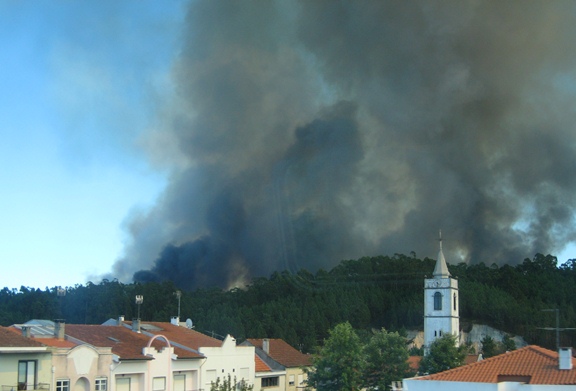
This happened in Ashbourne… possibly the Ashbourne that is in the UK.
Monday morning one-liners

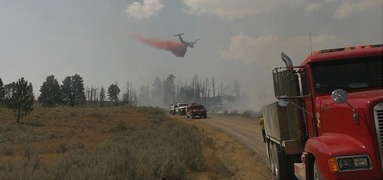
On Sunday firefighters stopped a fire after it burned 326 acres north of Pompeys Pillar in Montana (see photo above).
The National Interagency Fire Center moved the national preparedness level from four to three.
Elizabeth Reinhardt of the USFS and Dick Bahr of the NPS are quoted in an article about how larger and more frequent fires over the last several decades have limited the size of some fires, as they move into the previously burned areas.

Hot, dry, and windy weather led to several large wildfires in Portugal on Sunday.
Thanks go out to Kelly
Southern California brush fire in San Gabriel Canyon

The Williams Fire started in San Gabriel Canyon north of Azusa in southern California Sunday afternoon and through the afternoon and evening grew to 3,600 acres. The origin was between Camp Williams and the shooting range along East Fork Road in San Gabriel Canyon about 3.5 miles east of Highway 39. A map showing the location of the Williams fire is below.

San Gabriel Canyon, which will be closed on Monday, Labor Day, typically sees over 10,000 visitors on a holiday weekend.
At least 300 personnel are assigned to the fire, as well as 9 air tankers, 4 helicopters, 30 engines, 2 dozers, and 4 hand crews. It is moving north through very steep terrain toward the Sheep Mountain Wilderness area. As of 2 a.m. Monday morning the fire was listed as 5 percent contained.
All of the photos below were taken by the crew on Air Tanker 911, a DC-10 which earlier on Sunday was repositioned from Casper, Wyoming where it had been based while working the fires in Nebraska, to Sacramento. From Sacramento it was dispatched to this fire, and Sunday night was at San Bernardino. The second DC-10, T-910, was recently released from their Call When Needed contract and sent home.


The LA Times has a nice collection of photos of the fire.
Firefighters making progress on Wellnitz fire in SD and NE

Firefighters are making progress on the Wellnitz fire that started August 29 north of Hay Springs, Nebraska and ran 28 miles north across the state line into South Dakota into the Pine Ridge Indian Reservation, stopping when it got to the community of Oglala.
The only heat detected by the MODIS satellite during its 2 p.m. pass on Sunday was near the Division A/B break at the state line (see map below), the result of a large slopover that drew “quite an air show” according to the Information Officer for the Rocky Mountain Incident Management Team A.
The fire has burned 96,000 acres, 63,000 in Nebraska and 33,000 in South Dakota. The IMTeam is calling it only 27 percent contained.
Below is a map of the fire provided by the IMTeam, prepared by Glenda Torres with data from 1200 hours on Sunday.
Continue reading “Firefighters making progress on Wellnitz fire in SD and NE”
Coordinating emergency management in California
The video describes how three of California’s emergency management agencies work together to suppress wildfires. It has some excellent video footage.
Thanks go out to Bill
The USFS battles fires and a fire analysis

Since Congress instructed the five federal land management agencies in 2001 to work together to pool their dollars and firefighting resources, not much has actually occurred toward accomplishing that goal. The objective was to allocate fire management budgets in locations with the greatest need, enhancing efficiency. This would mean reducing the money going to areas with low fire occurrence, and transferring those excess funds to underfunded areas with a higher incidence of fires.
The agencies paid a forest economics professor, Douglas Rideout, to develop a computer model that would, if not make decisions about where to allocate fire funds, at least provide information to enable managers to redistribute dollars. While the first version of the model called Fire Program Analysis (FPA) died a painful death, a revised edition is now being considered by fire managers for the US Forest Service, National Park Service, US Fish and Wildlife Service, Bureau of Land Management, and the Bureau of Indian Affairs.
An article in the Denver Post states that the U.S. Forest Service was unwilling to face politicians who had firefighting budgets reduced in their states. The article appears to be very well researched, and quotes some people who were very involved with the FPA, including Steve Botti, the retired fire budget guru for the National Park Service, and Chester Joy, a retired U.S. Government Accountability Office natural resources expert.
Here is an excerpt from the article.
Joy, the retired GAO expert, said the initiative “got strangled in the crib.”
He said the Forest Service was unwilling to take on Sen. Ted Stevens, the Alaska Republican who served as chairman of the powerful Senate Appropriations Committee.
In Interior, “the Bureau of Land Management was on board. The BLM was willing to do it. The Forest Service sunk it,” Joy said. “The Forest Service responded, ‘There’s no way we’re taking this to the Hill. There’s no way.’ And that was the beginning of the end.”
Thanks go out to Gary


