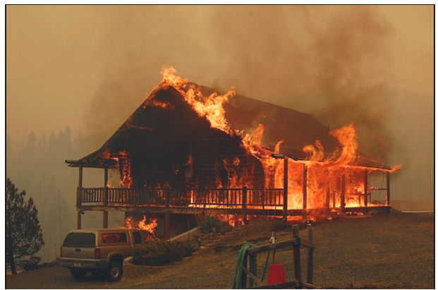
Fires won’t ruin hunting, but they can rearrange your trip

Fires are burning hundreds of thousands of acres of prime hunting ground in central Idaho. But Mike Demick with Idaho Fish and Game says hunters don’t need to worry about a ruined season. “It may affect where they want to go or where they went in the past, but overall the fires are a small percentage,” Demick told KBOI News. “There’s still millions and millions of acres out there where people can hunt.”

He explained that wildfires benefit the habitat for wildlife, producing more open country with grass and forage for big game species.

Just don’t get trapped.

The Alpine Lake Fire northwest of Lander, Wyoming, roared down a mountain toward five fishermen camped at a favorite spot. Twenty-two miles into the rugged Wind River Range on August 13, San Diego angler Larry Landeros, his father-in-law, his brother-in-law, and two friends watched as the forest around them went up in flames.

The Casper Star Tribune reported that Landeros, an officer with the California Highway Patrol, has been fishing Alpine Lake for 25 years. The group made a 10-hour horseback trip into the area. They saw a small smoke column off in the distance but weren’t too concerned about it; their outfitter rode back out and reported the fire the next day.

The next day, though, a helicopter landed at the lake and firefighters came out of the forest and told the fishermen that the fire had surged and jumped over part of the lake and river. The fire was under a hundred yards from the lake. They pulled their tents and carried their stuff onto a green, grassy peninsula that stretched out from shore into the lake; the fire torched up in the middle of the night, but the fishermen were safe on their little peninsula.
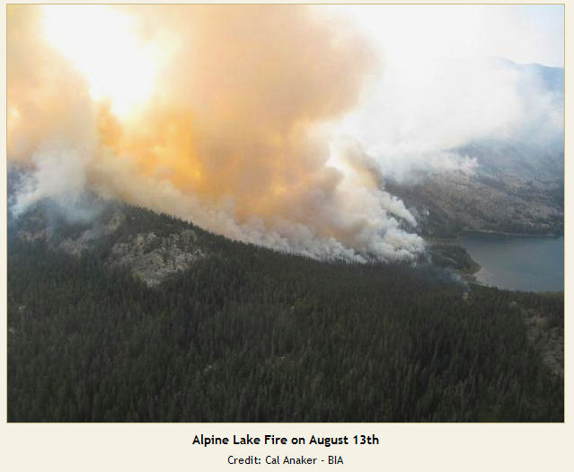
Alpine Lake Fire
Their outfitter, meanwhile, learned from the USFS that the way in was blocked by fire and he couldn’t go back in after the fishermen. A helicopter took them out the next day, flying them out in three separate trips.

Heads up out there, people.

The Parish Cabin Fire in eastern Oregon trapped a Portland couple who were bowhunting in the wilderness; they managed to make it to safety without a helicopter evacuation.

Spearfish homeowners’ association receives Firewise award

Firewise communities are designated to ensure protection against wildfires, and they’re more important than ever in drought years with huge fuel loads and diminished firefighting resources.

“It’s kind of scary right now with all the wildfires because it’s just so dry,” said Mary Hayenga with the Mountain Plains 2 subdivision homeowner’s association. “Our goal is to make sure everyone has taken the necessary steps to protect their property from wildfire.” Hayenga heads up Firewise efforts in her neighborhood in Spearfish, South Dakota, and the Black Hills Pioneer reports that residents recently received a Firewise award for 10 years of participation in the program.
Firewise
“If we can save one home,” she said,, “it’s worth the effort, because all we keep hearing is that it’s not a matter of if …  it’s a matter of when.”

The Firewise Communities Program encourages local solutions for wildfire safety by involving homeowners, community leaders, planners, developers, firefighters, and others in reducing the risk wildfires in their area. The program through the National Fire Protection Association is co-sponsored by the U.S. Forest Service, the U.S. Department of the Interior, and the National Association of State Foresters.

Hayenga said that after the Maitland Road and Jasper wildfires 12 years ago, the subdivision’s residents formed a wildfire committee to encourage homeowners to reduce fuel loading on their properties. They also made efforts reduce dead wood by fighting the pine beetle, which before this year’s flight had infested more than 144,000 acres of national forest lands. In 2002, the committee formed a Firewise plan and conducted tours of area homes to assess the situation. Hayenga said homeowners have been enthusiastic about reducing fuels on their property or have hired loggers to handle the task.

Montana fires ripping under red flag conditions

Firefighters struggled yesterday in fighting Montana wildfires that have burned homes and caused injuries. One new fire was reported south of Ashland, and two others erupted in Gallatin Canyon south of Bozeman. One of the Gallatin Canyon fires was contained by late afternoon. The 19 Mile Fire is about 2 percent contained at 4,000 acres; it’s southeast of Butte, south of I-90 and north of Highway 2. Firefighters are working on structure protection in the Whiskey Gulch area.

19 Mile Fire
The 19 Mile fire torched this and other residences on Thursday. Photo by Steve DiGiovanna, Madison County Disaster & Emergency Services.

According to an AP report, a new wildfire in Paradise Valley near Yellowstone National Park took off Wednesday and resulted in minor injuries to firefighters and members of the public. The Pine Creek Fire caught residents unaware; they were forced to flee the village of Pine Creek, south of Livingston, without packing any bags. Park County Commissioner Marty Malone said about 200 people live in the area and that some tried to fight the fire themselves, including a man who turned a hose on the flames until the power to an electric water pump was cut off by the fire and the water stopped running.

The fire’s now at 12,000 acres with zero containment; a red flag warning is in effect through Saturday. There are approximately 150 personnel assigned, including two hotshot crews, nine engines, two water tenders, two dozers, and four helicopters. Additional resources will be arriving throughout the day.

Pine Creek Fire Map
Pine Creek Fire Map 08/30/2012 @ 9 a.m.

Some residents have been allowed back to their homes. East River Road is closed from the north junction at highway 89 down to just south of Barney Creek. Pine Creek Road is also closed. Areas that are still closed to all residents are those that live on Deep Creek Road, Deep Creek Bench Road, and Deep Creek Road South Fork. The area from Pool Creek down south to Barney Creek is closed to all residents, and also along Pine Creek Road.

High temperatures and erratic winds have pushed the fires through drought-dry fuels. With nine large fires burning in Montana, officials said there was increasing competition for adequate equipment and personnel. “We are making do with what we can get,” said U.S. Forest Service information officer Karen Tuscano.

Woman dies during evacuation ahead of Nebraska fire

A 64-year-old Chadron woman died Wednesday during evacuations ahead of the West Ash Creek Fire in northwest Nebraska. The Omaha World-Herald reported that Chadron dispatch logged a call from a neighbor, who discovered the woman with breathing difficulties when they went to check on her during the evacuation. The sheriff’s department and an ambulance responded; she was pronounced dead at the hospital. Preliminary reports are that the cause of death was a heart attack.

The sheriff’s department evacuated about 150 Dawes County residents and closed Chadron State Park. The sheriff has since issued a mandatory evacuation for residents in the west and south of the Metcalf Wildlife Area north of Hays Springs, because of a third fire in that area.

The Region 23 Complex fires have burned nearly 69,000 acres; the complex comprises two fires, the West Ash Fire near Chadron, and the Douthit Fire near Crawford. Containment this morning is estimated at 25 percent.

The fires were estimated at only 1,300 acres on Wednesday, but grew quickly as hot winds pushed flames through the dry timber and grasslands. Smoke forced additional road closures on Sand Creek, Cottonwood Road, and Highway 20 west of Fort Robinson. Sections of Table Road near Willow Creek Church are closed because of increased fire activity in the area. Highway 385 is open, but controlled in areas with one-lane traffic and pilot car.

The Lincoln Journal-Star reported that the two fires in Dawes County were started by lightning Tuesday. One is south of Chadron and the other’s burning between the smaller towns of Harrison and Crawford. State officials also were responding to fires in Sheridan and Sioux counties, all in the Nebraska Panhandle. Gov. Dave Heineman on Thursday dispatched the state’s mobile operations center to the region.

Fires in Nebraska blacken more than 25,000 acres

Northwest Nebraska fires, 10:54 p.m. MT, August 30, 2012.
Northwest Nebraska fires, 10:54 p.m. MT, August 30, 2012. MODIS/Google (click to see enlarged version)

UPDATE at 11:47 a.m. MT, August 31 2012:

Below is another update from Beth Hermanson:

Fire officials report progress on the Region 23 Fire Complex, now 25% contained with portions of the Douthit fire northwest of Crawford possibly moving into mop-up status. Progress was also made on the West Ash fire southwest of Chadron to secure more lines to help with structure and property protection. Fire crews plan to make the most of calm early morning conditions, anticipating mid-morning changes.

A Red Flag Fire Weather Warning is the primary challenge facing fire crews on the combined 68,689 acre Region 23 Complex, with today being the first of a possible three-day warning. Forecasters anticipate a warm front moving into the area mid-morning that will shift winds to the south and bring higher temperatures with drier conditions. The southerly winds may become strong with gusts up to 30 mph or more.

Safety will be the highest priority today, knowing conditions are changing. Ed Wagonner, Operations Section Chief of the Rocky Mountain Incident Management Team C stated, “Today is critical for these fires because it’s the first of three possible Red Flag Days, and we really don’t know how the fires will respond to the winds.”

One of our loyal web site visitors in Custer, South Dakota told us that they heard radio traffic indicating that a very large air tanker was ordered for the fire, with an ETA of around 4-5 p.m.

=============================================================
UPDATE, 2:37 a.m. MT, August 31, 2012:

We have an updated map, above, showing heat detected by a satellite at 10:54 p.m. August 30, 2012.

Here is new information about two of the three fires from Beth Hermanson, a public information officer with the Incident Management Team:

More than 68,689 acres have burned in the Region 23 Complex fire in northwest Nebraska according to Rocky Mountain Incident Management Team C officials.

The complex consists of two fires — the West Ash Fire near Chadron and the Douthit Fire near Crawford. The fires started by lightning, Aug. 28. Containment of the fires is estimated at 10 percent. West Ash accounts for 44,354 acres and the Douthit fire has burned 24,335 acres.

The fires are in rugged inaccessible terrain burning ponderosa pine and grass. Fire fighters focused on fire suppression today as well as evaluation of the fire perimeter. Red flag warning is expected to continue, possibly for the next three days. Fire fighters are working through the night preparing areas of the fire likely to be affected by potential high winds over the next several days.

===========================================================

(originally posted at 8:50 p.m. MT, August 30, 2012)

Fires in northwest Nebraska have burned more than 25,000 acres since lightning ignited the blazes on Tuesday.

The map of the fires above shows heat detected by a satellite at 1:31 p.m. MT on August 30, with the red color being the most recently mapped.

A Type 2 Incident Management Team with Joe Lowe as Incident Commander assumed control of two of the fires Thursday morning. The Douthit Fire between Crawford and Harrison and the West Ash Creek Fire between Chadron and Crawford are zero percent contained.

Spokesperson Beth Hermanson said some structures have been lost but did not know the exact number.

Information about current evacuations can be found at InciWeb.

DC-10 air tankers have dropped more retardant than the MAFFS C-130s

Two, DC-10 air tankers
10 Tanker Air Carrier’s two DC-10 Very Large Air Tankers. Photo: 10 Tanker

The two DC-10 air tankers operated by 10 Tanker Air Carrier have dropped more retardant this year than the seven to eight Modular Airborne FireFighting System (MAFFS) C-130 aircraft flown by the military. The DC-10s have dropped, according to 10 Tanker, 2.408 million gallons through August 27 during 215 flights for an average of 11,200 gallons per flight.The MAFFS, according to the August 29 Government Security News, have dropped 2.153 million gallons through August 24, employing 899 flights to do so. This indicates an average of 2,394 gallons per flight for the MAFFS aircraft.

The DC-10s have a Call When Needed contract with the U.S. Forest Service and are only activated when the USFS decides to use them. This year one of them, Tanker 911, was called up (these dates are approximate) June 11 and released on June 16. It was reactivated around August 3 and the second DC-10, Tanker 910, was put on active duty on approximately August 7.

One of the eight MAFFS C-130s crashed July 1, 2012 while dropping on the White Draw fire west of Hot Springs, South Dakota, killing four crewpersons and injuring two. While the military has many C-130s, there were only eight of the second generation MAFFS2 units which can be loaded into the cargo hold of the aircraft making it possible for it to hold up to 3,000 gallons of fire retardant. And of course the crew can’t be replaced, only substituted.