A late fire season in Germany

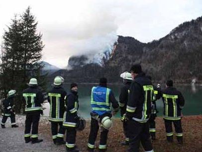
Georg in Germany sent us an update about the wildfire situation in his country.

After an unusual period without any rain, the southern part of Germany and Austria is seeing it`s latest wildfire-season in history. Terrain difficulty: very high. Growth potential: high.

I know, it`s not that spectacular through the eyes of an american (wildland) firefighter, but until this year nobody even expected a wildfire in Germany in November. Also remind it`s a country without any handcrews or strike-teams for wildfire suppression.

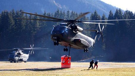
There are four helicopters in service in a incident near Lenggries-here a video including some drops. It`s a Sikorsky S-65 (CH 53) operated by german Army “Heer”,dropping 1300 gallons of Water.

HERE is a link to a video that shows some helicopters in action, and an interview with what I assume is a fire official. Thanks to Google Translate, the caption below the video says, roughly: “For more than 50 years November was not as dry as this year. Now in the middle of the Bavarian Alps, a forest fire has broken out. Fire and Mountain Rescue is a day-long use before.” As the video begins, you may hear a voice-over for a commercial, with the announcer speaking in a very soft voice… in German. Interesting.

More still photos are HERE.

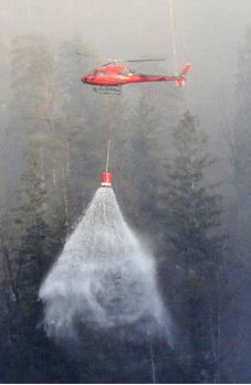
Below are a few samples of the photos:


In the photo above, it appears that the water bucket has some sort of dispersing mechanism, such as a rotating device which scatters the water. I’ve never seen this in North America. I wonder if the Germans are on to something here?

Thanks Georg

GAO issues report on Arizona Border area fires

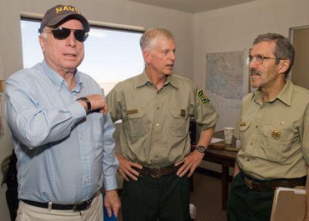
McCain, Tidwell, Harbour at Wallow fire
Sen. John McCain, Thomas Tidwell (Chief of the Forest Service), and Tom Harbour (Director of Fire and Aviation, USFS) at the Wallow fire, June 18, 2011. Photo by USFS.

On June 18 Senator John McCain flew with Tom Harbour, Director of Fire and Aviation for the USFS, and Thomas Tidwell, Chief of the Forest Service, to Arizona to be briefed on the Wallow fire. He met with reporters that day and started his own firestorm when he was quoted as saying:

There is substantial evidence that some of these fires have been caused by people who have crossed our border illegally. The answer to that part of the problem is to get a secure border.

McCain received a great deal of criticism for his rather vague statement, some of which accused him of unfairly pointing the finger at “vulnerable populations”. It was not clear to which fires McCain was referring, but two cousins from southern Arizona were charged with starting the Wallow fire by leaving a campfire unattended. McCain may have been thinking of the Monument fire which started June 12 near the Arizona/Mexico border and, according to a well-publicized theory by Cochise County Sheriff Larry Dever, may have been caused by illegal border crossers. We checked today and the cause of the Monument fire is officially still “under investigation”, according to the Coronado National Forest.

It turns out that in 2010 McCain and three other senators, Lisa Murkokwski, John Barrasso, and Jon Kyl requested that the Government Accountability Office (GAO) conduct a study about wildfires in the Arizona border area. The 55-page report which was released today, covers:

  • The number, cause, size, and location of wildland fires from 2006 through 2010;
  • Economic and environmental effects of human-caused wildland fires burning 10 or more acres;
  • Extent to which illegal border crossers were the ignition source of wildland fires on federal lands; and
  • Ways in which the presence of illegal border crossers has affected fire suppression activities.

From the report, here are some numbers relating to Arizona border area fires. The GAO looked at data for fires that occurred from 2006 through 2010:

  • 2,467 fires were examined in the report
  • 2,126 or 86% of the fires were caused by humans
  • 1,364 fires burned less than one acre
  • 1,553 or 63% of the 2,467 fires started on federally managed or tribal land
  • $35 million, the suppression costs for the fires that burned more than 10 acres
  • ?… the number of fires ignited by illegal border crossers on federal lands is not known because not all fires were investigated
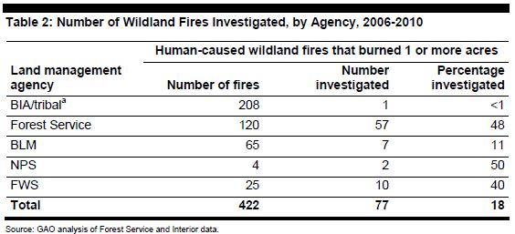
  • 422 human-caused wildland fires occurred on Forest Service, Interior, or tribal lands and burned at least 1 acre
  • 77 of the above 422 fires were investigated.
  • 30 (or 39%) of the above 77 investigated fires were identified as being caused by illegal border crossers
  • 57 additional fires were not formally investigated but were suspected (by individuals who completed fire reports) of being caused by illegal border crossers
  • 4% of the 2,216 human caused fires were identified by investigators or by individuals who completed fire reports as being caused by illegal border crossers

Below are three graphics from the GAO report, followed by Conclusions and Recommendations:


Continue reading “GAO issues report on Arizona Border area fires”

Reno’s Caughlin fire contained, update on homes burned

Caughlin fire Reno 11-20-2011
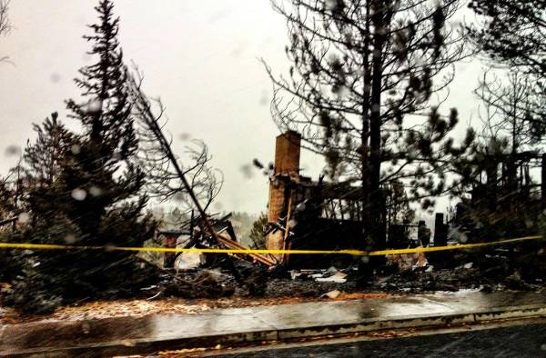
Damage caused by the Caughlin fire in Reno. Photo November, 20, 2011 by Ben Davis

The fire in Reno that burned until the winds decreased and snow began falling was contained Sunday night at 6:00 p.m. Mark Regan of the Sierra Fire Protection District told Wildfire Today that the incident management team is almost finished with the evaluation of the structures that are damaged, and the count of uninhabitable homes stands at 29, with 7 that are damaged but habitable. The 1,935-acre fire was turned over to the Reno Fire Department at 8:00 a.m. on Monday.

Emergency personnel placed one of two placards on homes to indicate the severity of the damage. Red ones mean it is unsafe to enter the home and residents should call 211. A yellow placard indicates significant damage and it is safe to enter with caution.

During a press conference Reno Fire Chief Michael Hernadez commented on the initial response to the fire. He said the fire call came in at 12:20 a.m. Saturday morning and within two minutes the response crews upgraded the fire. Within minutes it went to a three alarm fire. “We threw everthing we had at it,” says Hernandez.

Crews have been working, sometimes in the snow, to rehab dozer and hand lines, constructing water bars for erosion control, and bringing the landscape back to its natural state. The snow has melted, however, and it’s partly sunny today in Reno.

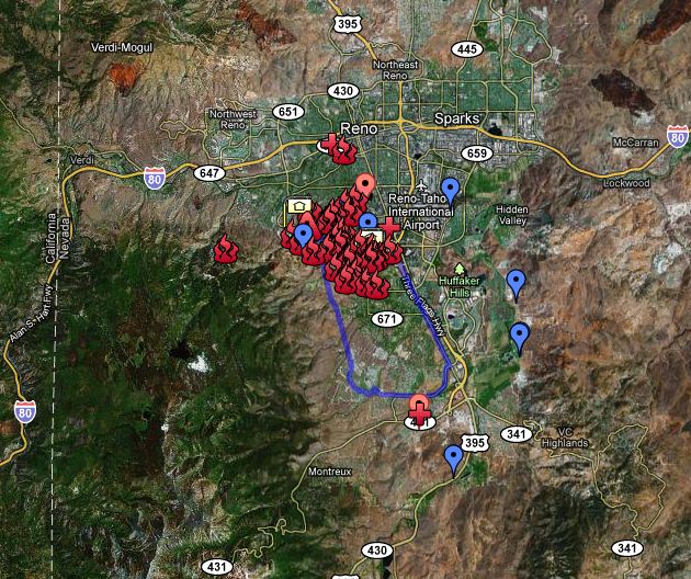
Here is an unofficial map of the fire made by Bryce Leinan:
Continue reading “Reno’s Caughlin fire contained, update on homes burned”

Snow helps firefighters contain Reno fire

Caughlin fire at Reno
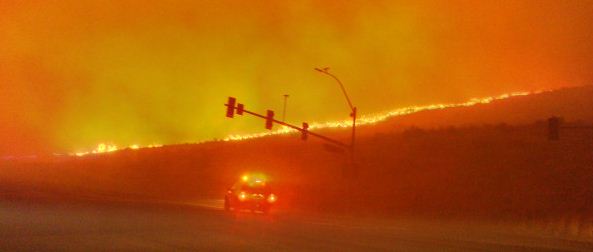
Caughlin fire at Reno 11-18-2011. Photo by Blake Houston

Snow and decreasing winds helped firefighters stop the spread of the Caughlin fire that burned 1,847 acres and caused the evacuation of 10,000 residents on the southwest side of Reno, Nevada on Friday. A report on InciWeb on Saturday said the fire destroyed 15 structures and damaged 40 others. The AP reports “the estimated number of homes destroyed in a wind-fueled wildfire more than doubled on Saturday to a total of 32”.

Fire Chief Mike Hernandez said on Friday a firefighter suffered first and second-degree burns while working on the fire.

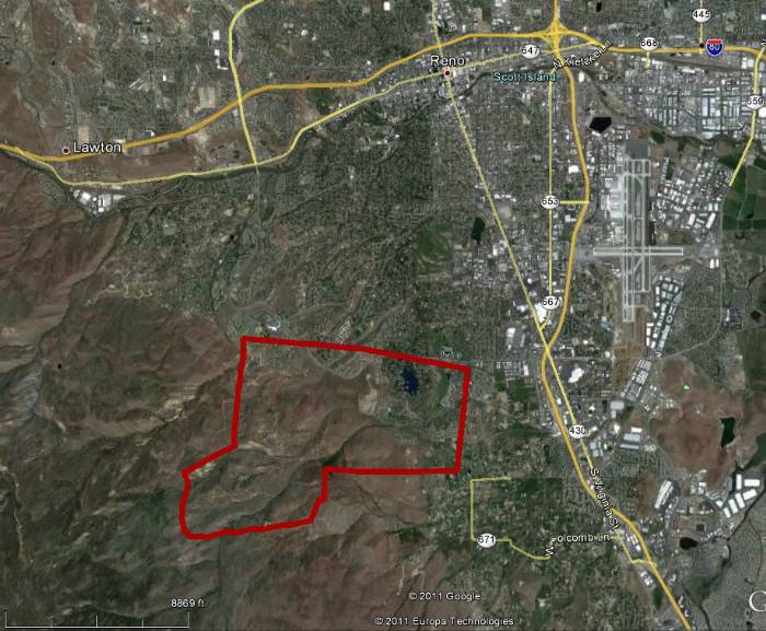
The map below shows the approximate location of the Caughlin fire, using data from the MODIS satellite system.

Map Caughlin fire Reno
Map of Caughlin fire at Reno, showing the approximate location. MODIS/Google Earth

Wildfire burns 20 homes in Reno

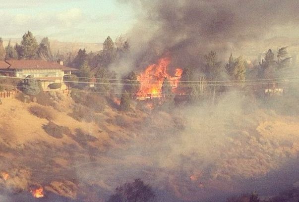
Caughlin fire Reno
A home burns in the Caughlin fire in southwest Reno at approximately 9 a.m. November 18, 2011. Photo by Sarah Bear

UPDATE: at 3:30 p.m. PT, Nov. 18

Reno Fire Chief Mike Hernandez said the Caughlin fire damaged or destroyed 25 homes but firefighters saved about 4,000 to 4,500 homes. He said the fire has burned 2,000 acres but the forward spread has stopped and firefighters are making good progress.

A 74-year old man suffered a heart attack and died during the evacuation and a local hospital treated 16 patients for respiratory conditions.

==================================

At least 20 homes in southwest Reno, Nevada have burned in the wind-driven Caughlin wildfire. The Reno Gazette-Journal reports that 9,500 people had been evacuated as of 9:53 a.m. on Friday, but at 10:32 the evacuation area expanded.

Map of Caughlin fire Reno 1125 11-18-2011
Map of the Caughlin fire area near Reno, 11:25 a.m. 11-18-2011 by "Bryce"

The above map showing the Caughlin fire area in Reno is unofficial and is produced by “Bryce”. It is the only map we could find and it may or may not be accurate. The blue line is supposed to represent the evacuation area. The map was obtained at 11:25 a.m. PT November 18, 2011. “Bryce” revises the map frequently, and the “live” version can be found HERE.

Governor Brian Sandoval spoke at a press conference Friday morning and announced that he had declared a state of emergency and requested help from California. Reno Fire Chief Michael Hernandez said at the time that the fire would remain a threat throughout the day, with active firefighting expected for the next 24 to 36 hours.

Friday morning the Federal Emergency Management Agency declared the fire to be a “major disaster” and approved a Fire Management Assistance Grant. As a result, Nevada is eligible for up to 75% funding assistance for eligible costs.

The strong winds that are driving the fire have caused the cancellation or delay of several flights at Reno-Tahoe International Airport.

Genny Wilson, the District Ranger of the Carson Ranger District on the Toiyabe National Forest said the fire has burned about 450 acres on the national forest, however most of the fire is within the city of Reno.

KTVN has frequent reports on the fire, and occasionally they have live streaming video.