Wildfires erupt overnight in California’s wine country

(Originally published at 7:57 a.m. PDT October 9, 2017)

(The Tubbs Fire burns in Northern California Monday, Oct. 9, 2017, as seen from this video posted on YouTube by Craig Philpott)

A series of fires fanned by high winds erupted Sunday night and Monday morning in California’s wine country, charring at least 20,000 acres and sending thousands of people fleeing homes, hotels and hospitals in the middle of the night.

The fires, many of which started late Sunday, burned out of control across hillsides in Sonoma and Napa counties, north of San Francisco and west of Sacramento. Multiple other counties were affected as smoke pushed into neighborhoods as day broke.

The largest, the Tubbs Fire, scorched in excess of 20,000 acres within just a few hours, Santa Rosa Fire reported. The fast-moving fire forced the evacuation of area hospitals, closed schools and led officials to recall all city employees to help staff the emergency operations center.

The Santa Rosa city manager and acting director of emergency services declared the situation a local emergency, according to the incident’s information page. 

“This is a life-threatening event,” the Santa Rosa Police Department said in a 2 a.m. alert regarding the evacuations. “Leave immediately.”

There was no immediate word on injuries to civilians or first responders.

The National Weather Services has issued a Red flag warning for the region until 5 a.m. Tuesday. North winds were forecast to gust to 30 mph through the day Monday before shifting to the south and diminishing by afternoon.

“Warm temperatures, low humidity and locally strong winds will coincide with critically dry fuels,” forecasters warned.

Red flag warnings were in effect across Northern California on Monday.

The nearby Marin County Sheriff’s Office reported no fires Monday morning but said its 911 dispatchers were overwhelmed with people calling to report smoke from other area fires being pushed into their neighborhoods.

Video from residents in the area shows the frantic evacuation efforts that unfolded Monday morning.

The exact magnitude of this event remains unclear as day breaks in the area. Photos circulating online, including several hosted here by The San Francisco Chronicle, show several structures, including homes, totally destroyed in the densely populated area.

Lion Fire update, October 6, 2017

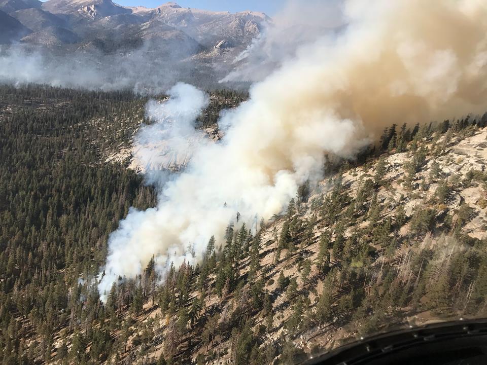
Above: A firing operation on the Lion Fire October 5, 2017. USFS photo.

(Originally published at 8:27 a.m. PDT October 6, 2017)

Firefighters in the Sequoia National Forest are using strategic fire as one of their main tools on the Lion Fire 30 miles northeast of Porterville, California in the Golden Trout Wilderness.

On Thursday a helicopter using a plastic sphere dispenser ignited fire on a rocky 9,000 to 10,000-foot elevation ridge, letting it back down the very steep slope toward the valley below. The incident management team reported Friday morning that the fire had grown to 8,100 acres, an increase of 250 acres over the previous day.

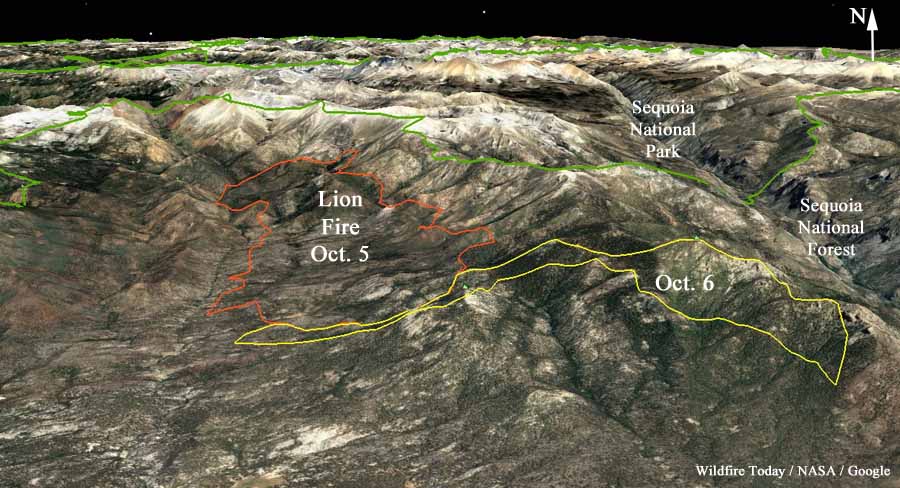
map perimeter of the Lion Fire
3-D map showing the approximate perimeter of the Lion Fire based on satellite data from October 5 and 6 2017.

Resources assigned include 8 hand crews, 3 helicopters, and 2 engines for a total of 221 personnel.

As promised Thursday the National Interagency Coordination Center stopped listing the Lion Fire Friday on their daily Situation Report because of a lack of “significant activity” even though it doubled in size on Wednesday. The fire is not being totally suppressed, but is being managed to protect private property.

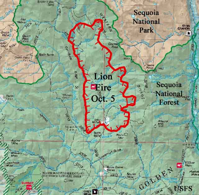
Perimeter of the Lion Fire October 5, 2017
Perimeter of the Lion Fire October 5, 2017. USFS map with large black text added by Wildfire Today.
Lion Fire
Lion Fire. USFS photo, uploaded October 3, 2017.


Lion Fire in Sequoia NF doubles in size

Above: Lion Fire in Sequoia National Forest. Photo uploaded to Inciweb October 5, 2017.

(Originally published at 11:22 a.m. PDT October 5, 2017)

After burning for 11 days since it started on September 24, the Lion Fire roared through the Sequoia National Forest Tuesday and Wednesday, doubling in size to 7,850 acres.

The fire is 10 miles northeast of Camp Nelson and 30 miles northeast of Porterville, California in the Golden Trout Wilderness.

Firefighters are working to protect the structures at the privately owned R.M. Pyles Boys Camp.

The Lion Fire is not being fully suppressed. Most of the current spread has been in an area that burned in the 2011 Lion Fire.

“This fire is spreading mostly through ground fuels in this remote part of the Wilderness,” stated District Ranger Eric LaPrice. “Efforts to contain the fire will be made along routes where firefighters can work safely while avoiding stands of dead trees and inaccessible terrain.”

Smoke is expected to settle into the valleys in the late evening and early morning hours due to inversion patterns that normally hold the smoke in low-lying areas.

A weather station about 8 miles southwest of the fire recorded single digit humidities Wednesday night into mid-day on Thursday. During that period west to northwest winds were blowing at 4 to 11 mph with gusts of 11 to 16 mph.

Oddly, the National Interagency Fire Center’s Situation Report said Thursday, while showing a 4,050-acre increase in size, “Last report unless significant activity occurs.” We might be confused about how NIFC defines “significant activity”. But they often distribute less information about fires that are not being suppressed.

The best thing you will see today

Above: Screen grab from the video of the Samoa fire crew.

Take a break from the depressing national news and watch the best thing you will see today. It shows a fire crew from Samoa apparently walking out of the forest, perhaps at the end of the day. And they are singing, acappella, a hymn — with some of the firefighters singing harmony.

It was filmed at the Helena-Fork Fire on the Shasta-Trinity National Forest in northwest California. The video was posted September 27, 2017 by Lori Light.

The video below was uploaded by Dean Vernarecci October 9, 2015, titled, “The Samoa fire hand crew do the HAKA at the Gasquet Fire”.

Below is another video of a fire crew from Samoa on a wildfire assignment. It was posted August 27, 2017 by Ronneesu who described it: “Prior to demobing, American Samoa Fire Crew shared culture and spirit with staff at Modoc National Forest Supervisor’s Office, Alturas, CA.”

Updated map of the Canyon Fire near Corona, California

Our unofficial estimate shows that the fire has burned approximately 2,650 acres.

Above: Map of the Canyon Fire at 7:50 p.m. PDT September 26, 2017.

(Updated at 8:37 a.m. PDT September 27, 2017)

Firefighters have had some success battling the Canyon Fire just southwest of Corona, California. On Tuesday it spread very little, however still remaining unburned islands of vegetation within the perimeter continued to put up smoke.

According to the Wednesday morning official update from the Incident Management Team evacuation orders are still in effect for all areas south of Green River Road from State Route 91 to W. Foothill Parkway, including the Skyline Drive Area. Eight schools in the area will continue to be closed on Wednesday, September 27.

Canyon Fire ma
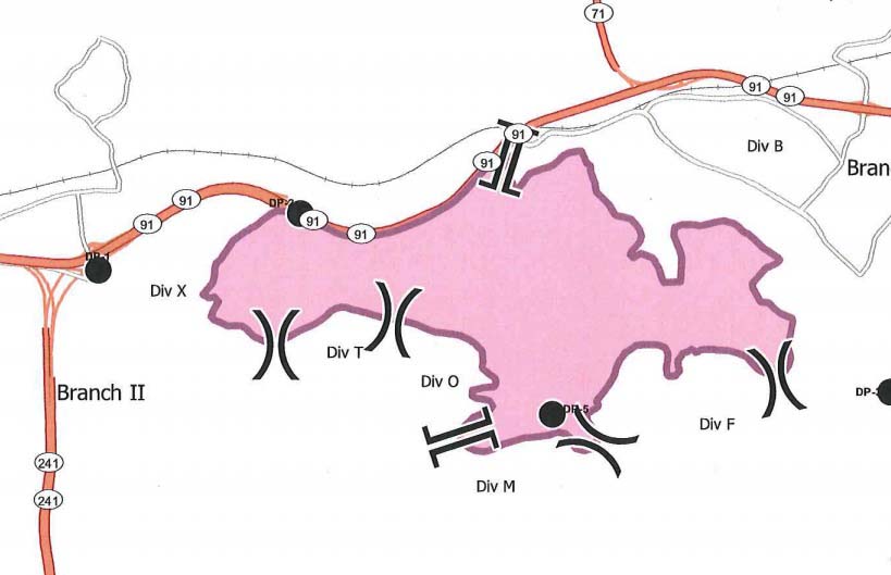
Canyon Fire map, by the Incident Management Team September 27, 2017.

The updated perimeter map shows that the fire burned well into housing developments on the west side of Corona but the incident management team reports that three structures were damaged but no homes were destroyed. This is a result of several things: outstanding efforts by firefighters who battled the flames and ember showers, the residents who prepared their properties well in advance to be more fire resistant, and the work by local agencies to educate citizens about how to live in a fire-prone environment.

Streets that were heavily impacted by the fire include San Viscaya Circle, San Ponte Road, San Ramon Drive, Oakridge Drive, Elderberry Circle, Goldenbush Drive, Bulrush Circle, Sageleaf Circle, Canyon Crest Drive, Wilderness Drive, and Hidden Hills Way.

Resources assigned to the fire include 272 engines, 10 water tenders, 11 helicopters, 10 dozers, and 30 hand crews for a total of 1,652 personnel. Two of the helicopters, from Orange County and the U.S. Forest Service, are capable of making water drops at night,

Our unofficial estimate shows that the fire has burned approximately 2,650 acres, but Wednesday morning the Incident Management Team is sticking with their 2,000-acre figure they have been using for several days.

Below are some of the best images and videos posted over the last couple of days about the fire on Twitter and Instagram.

Continue reading “Updated map of the Canyon Fire near Corona, California”