Cedar Fire near Show Low, Arizona

(UPDATED at 10 a.m. MDT June 24, 2016)

cedar fire helicopter
Helicopter refilling water bucket on Cedar Fire. Undated & uncredited photo from InciWeb.

The Cedar Fire south of Show Low, Arizona continues to spread across the Arizona landscape. The Incident Management Team reports that it has burned 45,918 acres, an increase of about 5,000 acres over the last two days. Firefighters still have miles of open fire perimeter and have been working on constructing firelines and conducting burnouts on the east and west flanks.
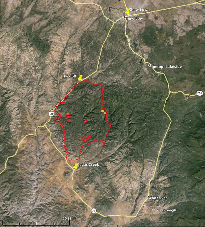
Map Cedar Fire
Map of the Cedar Fire perimeter at 9 p.m. MDT June 23, 2016.

SR-60 between Carrizo and Show Low remains closed due to smoke conditions as firefighters actively work near the highway. SR-73 through Whiteriver remains open from Carrizo to Hon-Dah.

****

(UPDATED at 9:42 a.m. MDT June 22, 2016)

3-D Map Cedar Fire
3-D Map of the Cedar Fire at 10 p.m. MDT June 21, 2016. Looking north.Click to enlarge.

The Cedar Fire south of Show Low Arizona added another 5,000 acres on Tuesday to bring the number acres burned up to 40,340, according to the Southwest Geographic Area Coordination Center. Most of the growth was on the east side, and on the west side near Highway 60.

The southern perimeter is still approximately 1 1⁄2 miles north of Highway 73, and approximately 2 miles north of the Cedar Creek community. The north side of the fire remains fairly quiet.
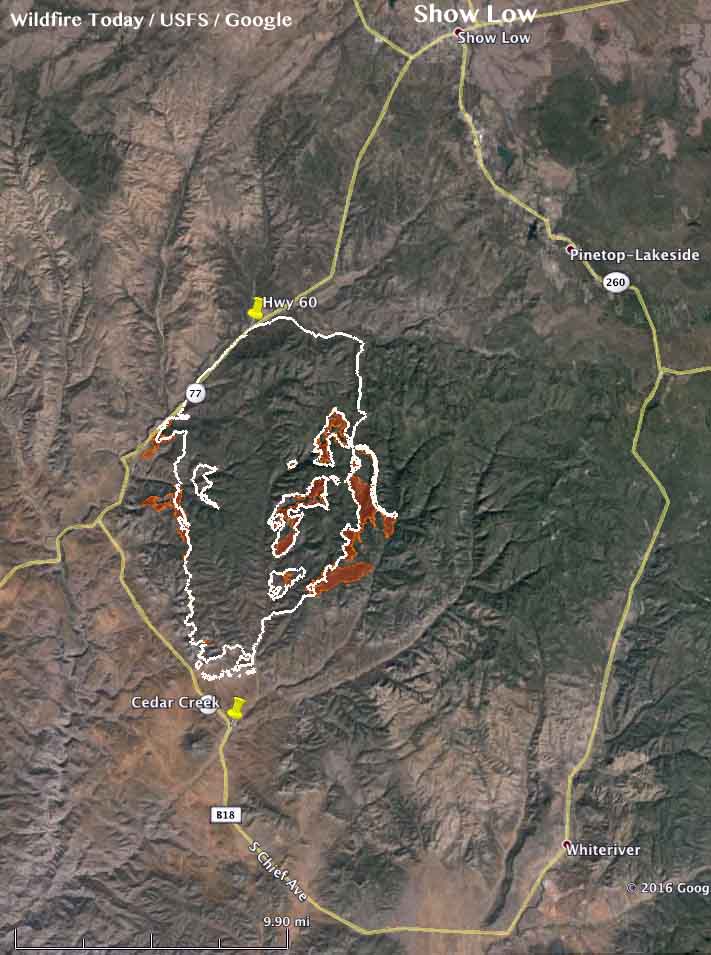
Map Cedar Fire
The brown shaded areas show the additional growth of the Cedar Fire as of 10 p.m. MDT June 21, 2016. The white line is the perimeter from 24 hours before. Click to enlarge.
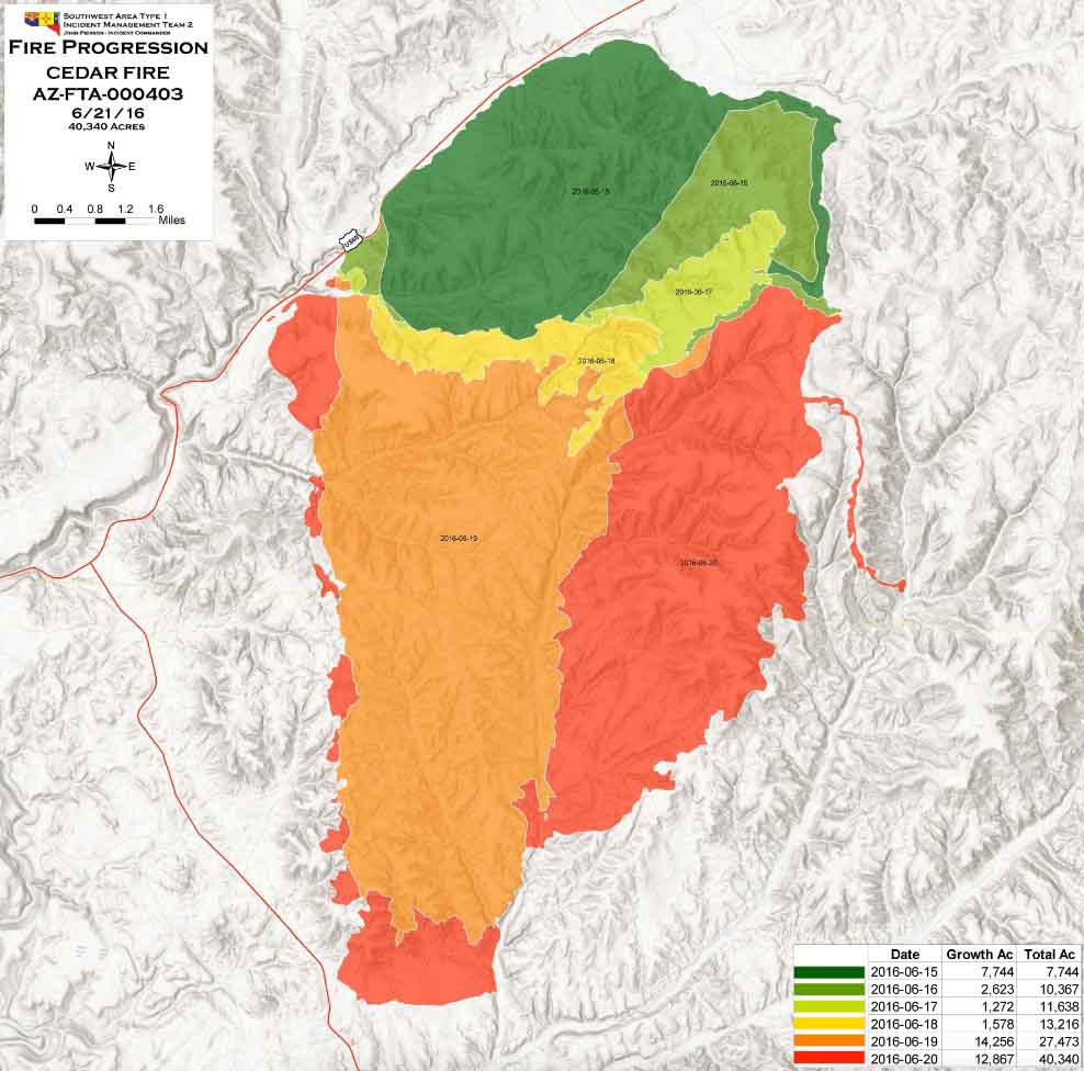
Progression map Cedar Fire
Progression map of the Cedar Fire, June 21, 2016. Click to enlarge.

****

(UPDATED at 8:20 a.m. MDT, June 21, 2016)
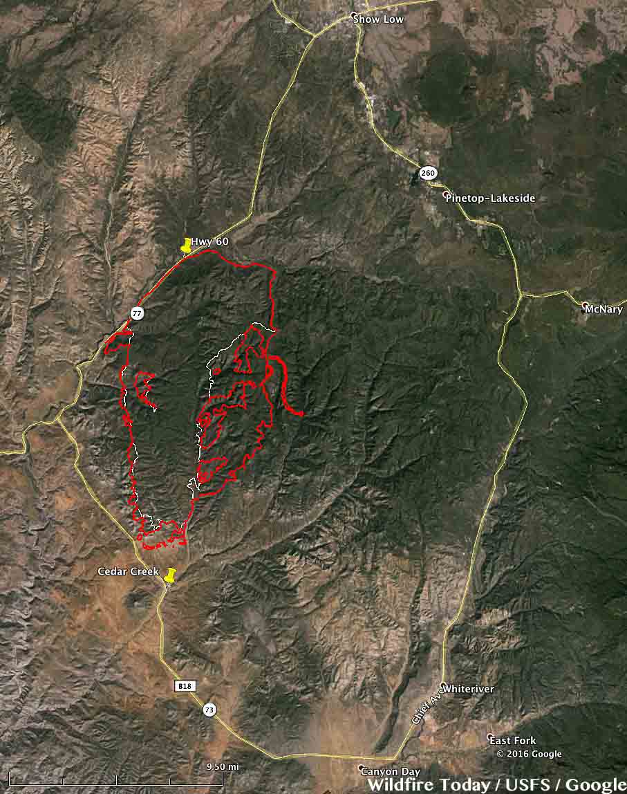
map Cedar Fire
The red line was the perimeter of the Cedar Fire at 4:13 a.m. MDT June 21, 2016. The white line was the perimeter from about 24 hours before. Click to enlarge.

The Cedar Fire south of Show Low, Arizona continued to grow substantially on Monday adding another 9,000 acres to bring the total burned area up to about 35,000 acres. The fire was active on the southwest and south sides, but was extremely active on the east side where it spread over two miles further east.

The Incident Management Team (IMT) has posted a video briefing on the fire that was recorded on Monday.

Continue reading “Cedar Fire near Show Low, Arizona”

Wildfire briefing, February 26, 2016

Pile burning on Modoc NF

pile burning Modoc NF
Burning hand-piled slash on the Modoc National Forest north of Alturas near Swanson Canyon. USFS photo.

Advanced leadership course examines the 2003 Cedar Fire

This week the IAFC put on a version of the National Wildfire Coordinating Group’s L-580 Strategic Leader Program, which is the highest level leader development course in the NWCG “L” series curriculum. It was titled San Diego County Megafires: An All-Hazards Interactive Case Study.

On Tuesday the class, which was limited to 32 participants, visited the site of the largest fire in the recorded history of California, the 2003 Cedar Fire that killed 15 people and burned 273,246 acres and 2,820 structures.

CW6 in San Diego has a video report on the training, but the article below the video has at least a couple of errors, including the year of the fire and the number of acres burned.

Dispute about USFS claims that 2015 was a record year for acres burned

An article in the Washington Post claims there is a dispute about the claims of the U.S. Forest Service that more acres burned in the United States in 2015 than any previous year.

Some environmental groups say that in the early part of the 20th century more acres burned than the USFS has recorded since more accurate records began being kept 55 years ago. Earlier statistics may have included massive numbers of prescribed fires conducted in the southern states.

One fact that most arguments about this issue miss is that in the contiguous 48 states plus Hawaii, fewer total acres burned than in an average year. Of the 10,125,149 acres blackened in 2015 in the United States, more than half of those acres were in one state, Alaska, with 5.1 million acres, which was more than quadruple their average of 1.2 million and the most acres burned since 2004 (6.6 million). Fire management in Alaska is very different from the rest of the country. Most of the huge state is very sparsely populated, making it possible for land managers to allow some large fires to burn virtually unchecked except where they might impact a structure or village. In those areas “point protection” is the key — establishing firelines, sprinkler systems, or burnout operations for relatively small areas, leaving the rest of the fire untouched.

In the other 49 states (we like to call them the “lower 49 states”) 5.0 million acres burned in 2015, about 700,000 less than the average of 5.7 million acres.

B.C. company trains firefighters in Indonesia

A British Columbia company, TREK Wildland Services, will be training 400 workers and firefighters in Indonesia on the use of the Incident Command System.

Firefighters in Victoria leave note after saving home.

The Cedar Fire, Sunday on Dateline

Sunday night, March 8, NBC’s “Dateline” will feature the Cedar Fire, the largest wildfire in the recorded history of California. In the one-hour episode of a three-part disaster series called “Escape,” narrator Josh Elliott visits the scene and interviews 14 survivors whose lives have been changed forever.

In 2003 the fire burned over 273,000 acres in San Diego County. During the first night on October 25, the fast moving fire driven by a strong northeast wind killed 14 people east of San Diego in Wildcat Canyon and Eucalyptus Hills who had little or no warning. Eight of those killed died while they were evacuating. The fire destroyed 2,232 homes in San Diego, Alpine, Harbison Canyon, Crest, Cuyamaca, Julian, and Santa Ysabel.

While trying to defend a house near Santa Ysabel, fire Captain Steven Rucker, 38, from the Novato Fire Department was overrun by the fire and killed on October 29, becoming the 15th victim.

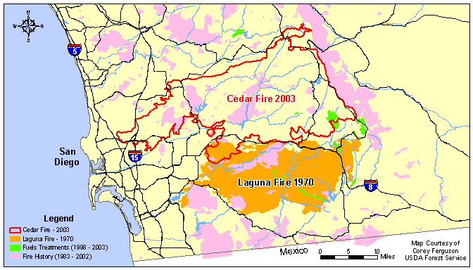
Map of Cedar and Laguna Fires
Map of Cedar and Laguna Fires, east of San Diego, California. USFS map by Corey Ferguson. (click to enlarge)

Below is a very interesting animation of the spread of the Cedar Fire, which was initially pushed by very strong Santa Ana winds blowing from the northeast and east.

(The animation is no longer available)

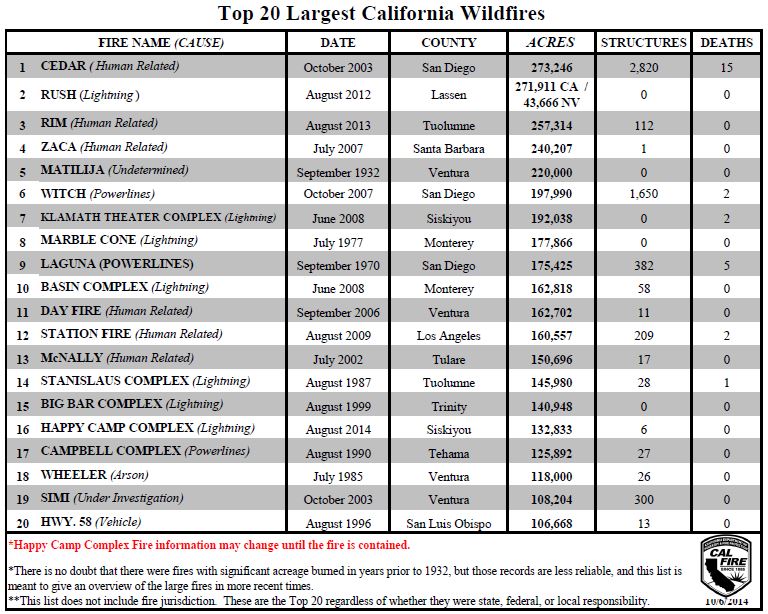
Largest California fires
The 20 largest fires in the recorded history of California. (click to enlarge)

Cedar Fire, California’s largest

Above: map of Cedar and Laguna Fires. USFS map by Corey Ferguson.

We continue to find retrospective articles about the largest fire in the history of California, the Cedar Fire, that started 10 years ago this month, on October 25, 2003. One of the more interesting is an animation of the spread of the fire which was initially pushed by very strong Santa Ana winds blowing from the northeast and east.

The fire was started by a hunter that got lost and wanted to improve his chances of being found. The 273,246-acre fire accomplished that goal and then some.

Just yesterday a hiker from Redlands, California who had been missing for nearly a week was found stranded in Coldwater Canyon about five miles above Arrowhead Springs Resort after he started a fire to stay warm, but the fire grew out of control. He was rescued after firefighters responded to suppress the fire which had spread to an area about 20 by 30 feet.

The San Diego Union-Tribune has an article that examines how the vegetation is recovering from the 2003 Cedar Fire. Below is an excerpt:

…The Cedar Fire and subsequent burns in 2007 wiped out more than half of the mixed conifer in San Diego County, according to park documents. Cuyamaca [State Park] saw the worst of it. Before the fire, conifers covered about 40 percent of the park, in pine-oak woodlands and mixed conifer forest, [Mike Puzzo, an environmental scientist with the park] said. All but a few stands were incinerated.

A decade later, the alien terrain left after the blaze is recovering to varying degrees. In some spots, such as Fern Flat, charred stumps are surrounded by what Puzzo called a “monoculture” of ceanothus.

In nearby West Mesa, where the fire burned less intensely, signs are more encouraging. Scrub and saplings mingle with 15 to 20 foot oak trees which shot up since the fire. Several miles away, in a meadow near Los Vaqueros, some large pines survived, and new ones are cropping up.

“I think this place is recovering very nicely,” Puzzo said. “This right here is a good representation of what a fire should do. Some is dead, but a lot is still alive.”

Sign in the Cedar Fire area
Sign within the Cedar Fire five months after the fire. Photo by Bill Gabbert.

The video below appears to have been shot by a homeowner in Poway as the Cedar fire burned near his home.

Another "Blue Ribbon Task Force" Makes Recommendations in California

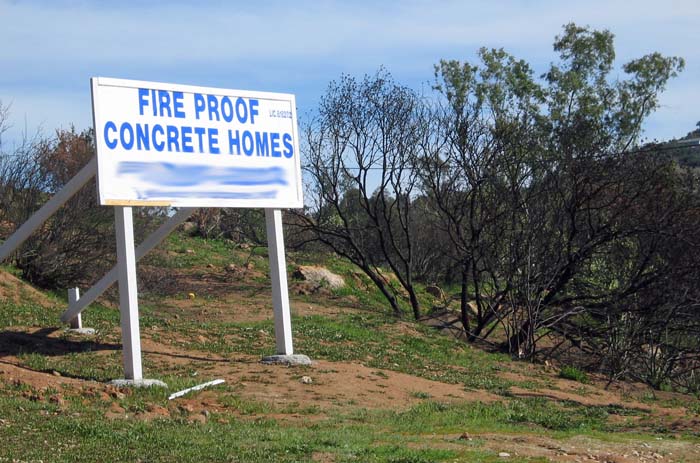
concrete Homes sign
A sign installed in Harbison Canyon within the footprint of the 2003 Cedar Fire east of San Diego. The fire burned 273,246 acres and 2,232 homes. Photo by Bill Gabbert, 2004.

The second Blue Ribbon Commission Task Force in California since the fires of 2003 presented its report yesterday about how to deal with large wildland fires in the state. The recommendations include more engines, more aircraft, more firefighters, fire safe construction, and better systems for real time communications and intelligence. Many of these were in the report following the 2003 fires but were not implemented because of the state’s fiscal problems.

Click here to download the 106-page report (788 KB).

Here is how the LA Times began their story on the report:

Three months after massive brush fires burned hundreds of homes across Southern California, a blue-ribbon task force on Friday made dozens of recommendations aimed at improving the response to large-scale blazes.

But many of the proposed measures are similar to those made after the devastating wildfires of 2003 — and many of those were never implemented because there was no money available.

And because the state is in a fiscal crisis, it remains unclear whether the new recommendations will fare any better. Several reports over the last decade have said California needs to increase the number of firefighting aircraft as well as boost the number of firefighters.

UPDATE: January 18, 2018. The links above no longer work, but found a copy of a 2004 Blue Ribbon Report about the 2003 fires. It is a huge 21 MB file.