Chile: Wildfires intensify, disaster impacts expand

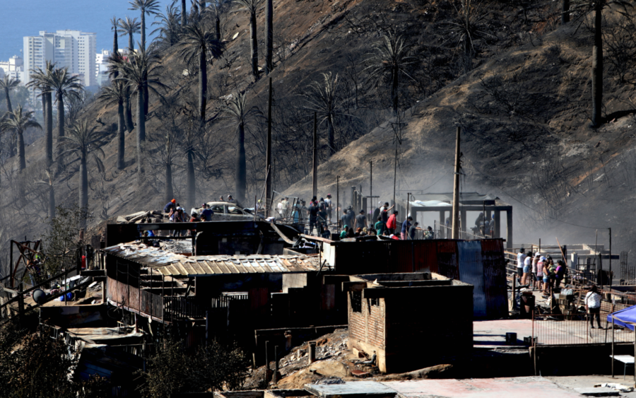
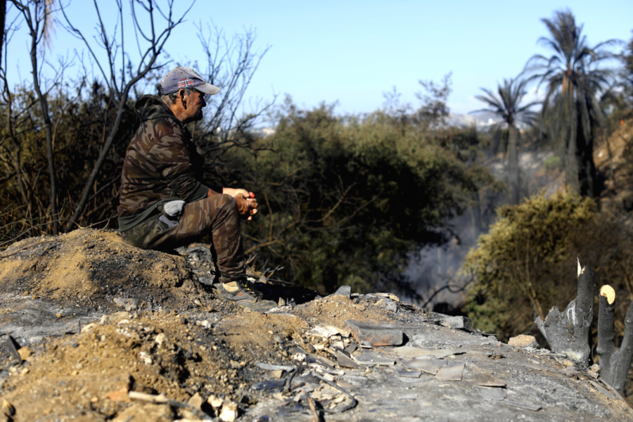
Satellite analyses and Twitter reports indicate a rapid growth of disastrous wildfires in south-central Chile yesterday (February 3) and overnight.

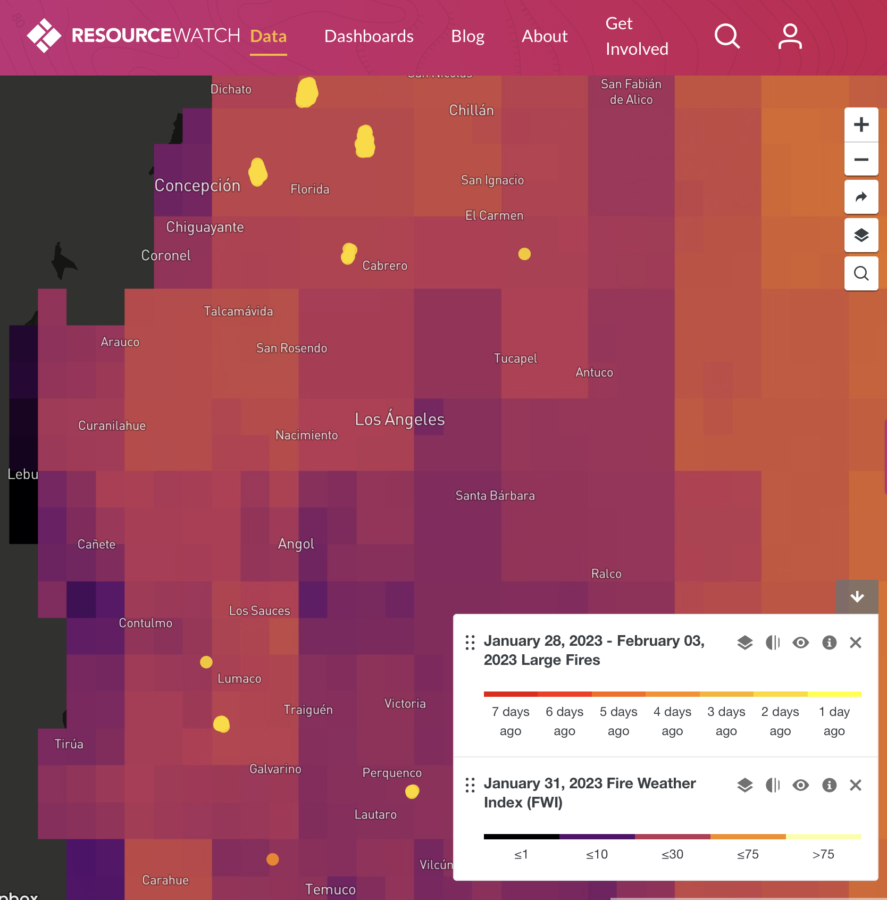
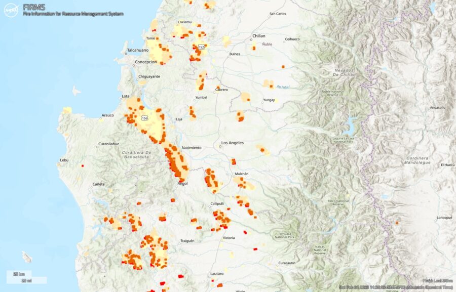
In the past 24 hours, satellite-based estimates based on NASA FIRMS data  indicate that the largest fire spread 80 kilometers (50 miles) west and northwest, impacting an area of nearly 100,000 hectares (230,000 acres). The fires appear to have spread from Renaico northwest toward the Pacific Coast city of Lota, while burning past Santa Juana and likely crossing north over the Biobío River.

In this NASA FIRMS map, the oldest yellow heat signatures are 24 hours or earlier, the most recent are red.

24-hour fire spread of largest fire in the Santa Juana are of Chile on Feb. 4, 2023. NASA FIRMS.
24-hour fire growth along a 80 km/50 mile line of the largest fire in the Santa Juana are of Chile on Feb. 4, 2023. NASA FIRMS.

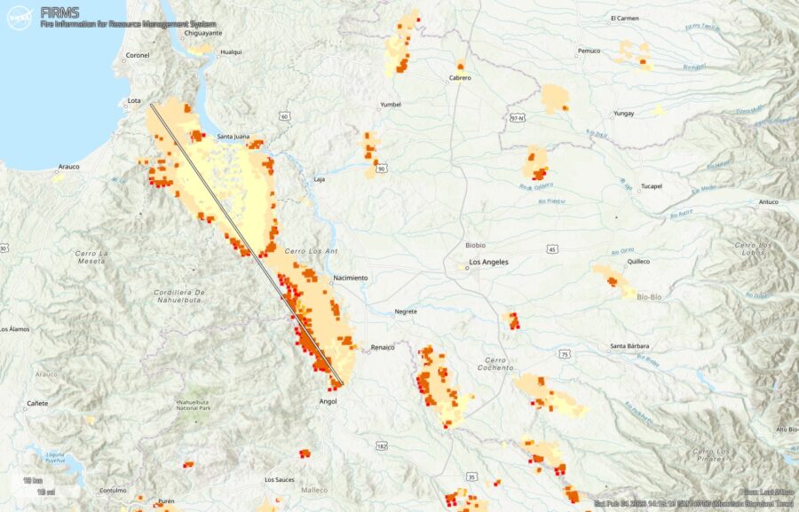
A larger map shows 24-hour fire detections for the affected regions of Biobío and La Araucanía. (And a reminder, as the FIRMS mapping tool, these heat signatures may overestimate fire size and activity, in part due to smoke columns and other factors.)

Overview of active fires in south-central Chile for the past 24 hours. Feb. 4, 2023. NASA FIRMS.

The fires detected by satellites are being confirmed via social media updates. As @HotshotWake reported via Twitter …
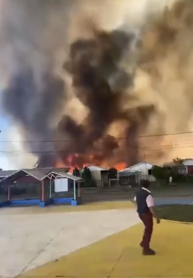
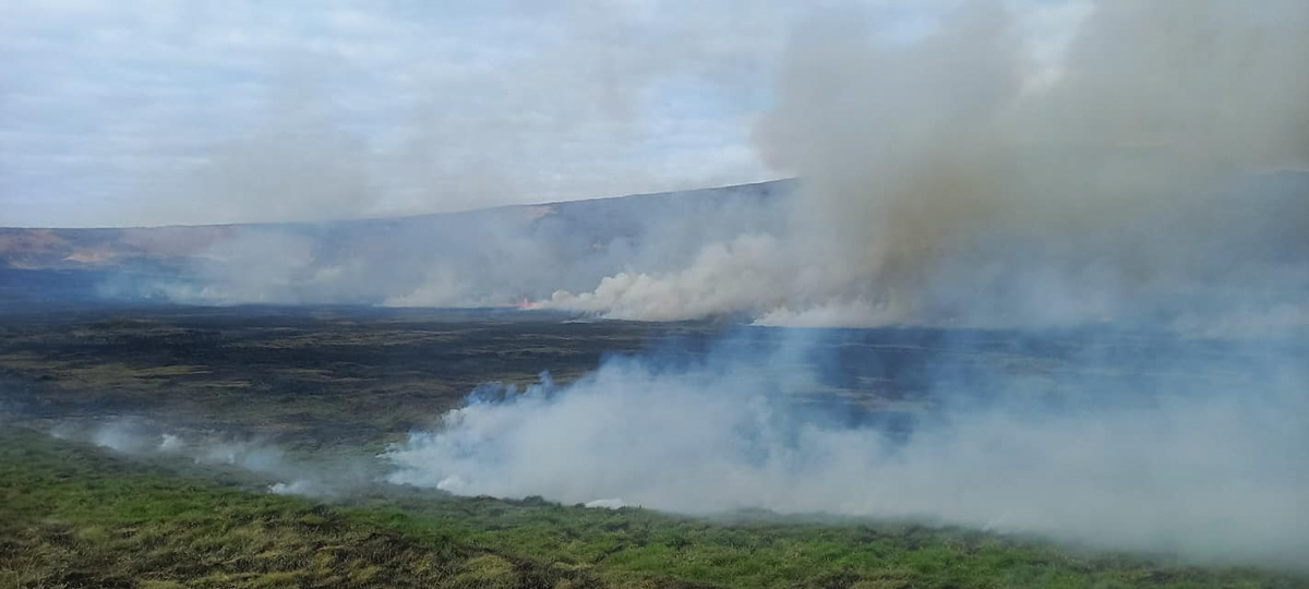
Also from February 3, @zoom_earth shared a satellite stream of fires and smoke…

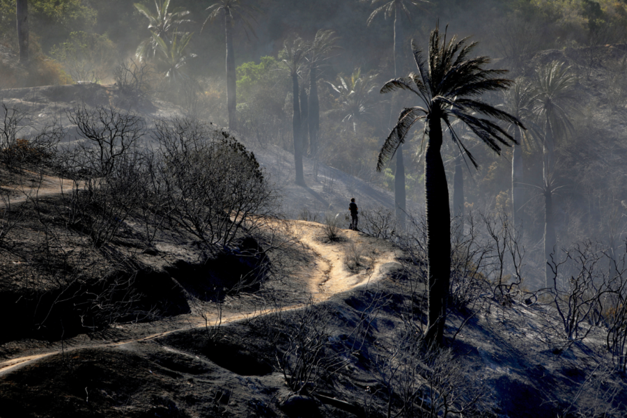
The Associated Press reported that the death toll as of February 4 has risen to 22 with more than 500 injured. The state of catastrophe has expanded to include the La Araucanía region, which is south of Ñuble and Biobío regions that were already in a catastrophe declaration.

13 die in ‘swarm’ of Chilean wildfires

A Bolivian pilot and a Chilean mechanic died when their helicopter crashed while firefighting in the commune of Galvarino, in the region of La Araucanía, 700 kilometers south of Santiago, Chile.

In statements reported on February 4 in MercoPress, Mauricio Tapiaby, deputy director of the Chiliean National Service for Disaster Prevention and Response noted that the pilot had “many years of experience in aeronautics and firefighting” and that 11 others, including a firefighter, had died on February 3 in a “swarm” of at least 50 uncontrolled fires. Tapia reported that 22 had suffered burns and 95 houses destroyed.

A Constitutional State of Emergency has been declared for the central-south regions of Biobío and Ñuble.

Chilean President Gabriel Boric activated Armed Forces and Carabineros for prevention patrols. “It is much easier to prevent a fire than to fight it,” he said, while adding that fire control activities were progressing with an estimated 75 aircraft and 2300 firefighters.

Temperatures of 40 degrees C (100 F) are being recorded, with moderating temperatures by next week but gusty afternoon winds continuing, and the recent Fire Weather Index in the 75th percentile.

Resource Watch: Large Fires and Fire Weather Index for central-south Chile, 2023-01-28 through 02-03.


Resource Watch: Fire Weather Index and Recent Fires

Additional reports shared via Twitter by @hotshotwakeup (https://thehotshotwakeup.substack.com) includes shared footage of communities being overrun by fire.

An official helps guide evacuees as a wildfire burns through houses in Chile.
An official helps guide evacuees as a wildfire burns through houses in Chile. Screenshot from video shared by @hotshotwakeup on Twitter.

In one video, a public official walks toward the fire and chaos to help guide the evacuees to a safety zone.

Updates can be monitored at ReliefWeb at https://reliefweb.int/disaster/fr-2022-000384-chl.

Aftermath in Viña del Mar, Chile

December 2022 in Chile was marked by record hot temperatures, with wildfires burning around the capital city of Santiago and producing persistent smoke and public health impacts. On December 22, a fire in a forested canyon of Tranque Sur burned into the coastal resort city of Viña Del Mar (north of Valparaiso), resulting in one death, many injured, and more than 100 homes destroyed. Chile’s president declared a state of emergency and catastrophe. A week later and 800 kilometers (500 miles) south of Viña Del Mar, firefighters responded to a fire in the Galvarino commune where a single-engine air tanker crashed on December 31, killing the pilot, Luis Sevillano Moreno, a Spanish national. 

For the early months of 2023, the forecast for Chile continues for hot, dry conditions.

A Chilean photojournalist, Carlos Vera Mancilla, was at Viña Del Mar as the fire was being controlled. Vera Mancilla has photographed many wildfires and their impacts, including a photo series in the January-February 2017 issue of Wildfire Magazine (https://www.iawfonline.org/wp-content/uploads/2018/02/26.1-Jan-Feb-2017-Wildfire-Final-Web-1.pdf) and excerpted below. One of his earlier photographs, from the 2016 protests in Santiago organized by relatives of the “disappeared”, gained acclaim as an image that conveyed the changing state of democracy in his country: https://www.cnn.com/2016/09/14/americas/chile-girl-protest-photo/index.html. 

Here is what he witnessed in 2022 in Viña Del Mar, with captions drawn from his notes. 

Vina De Mar, Chile - Day 2 Fire Control
Viña del Mar – Alto Forestry Sector. The remaining fires are being controlled on Day 2 (December 23, 2022). Displaced residents look on from the burned Tranque Sur urban sector of “autoconstrucción viviendas” — homes that were self-constructed, built by the residents and community members, sometimes referred to as “mutual aid” — more at https://infoinvi.uchilefau.cl/glosario/autoconstruccion/. The burned houses bordered along real estate and resort complexes. Photo: Carlos Vera Mancilla.
Vina Del Mar, Chile - debris removal.
Authorities and local citizens work in solidarity as they remove debris from burned buildings and provide humanitarian assistance. Photo: Carlos Vera Mancilla.
Vina Del Mar, Chile - a resident's sorrow.
Because of negative situations that occurred recently with the national press, I did not dare to consult his name — his sorrow collapsing with the Tranque Sur’s destructive fire. Photo: Carlos Vera Mancilla.
Vina Del Mar, Chile - a forest-urban fire.
A forest and urban fire. With the desolation of nature and the inhabiting community, there is no convincing explanation for the community of what happened, nor resignation to the disaster as recovery begins. Photo: Carlos Vera Mancilla.

+

Photos of fire damages from January 2017 in Valparaiso, Chile, by Carlos Vera Mancilla, from the January-February 2017 issue of Wildfire Magazine.

[pdf-embedder url=”https://wildfiretoday.com/wp-content/uploads/2023/01/26.1-Jan-Feb-2017-Wildfire-Mancilla_Chile-pages-16-17.pdf” title=”26.1-Jan-Feb-2017-Wildfire-Mancilla_Chile pages 16, 17″]

Fire on Easter Island damages iconic statues

Wildfire on Easter Island damages iconic statues. Municipalidad de Rapu Nui photo.

Approximately 80 of the famous stone figures on Easter Island were damaged by a wildfire on October 5 local authorities say. The statues, known as moai which range in size from 6 to more than 30 feet tall, were affected by the fire that burned about 148 acres of the Rapa Nui National Park on the island which is part of Chile. There are an estimated 416 moia in that area of the island.

Wildfire on Easter Island damages iconic statues. Municipalidad de Rapu Nui photo.

Moai are made of lapilli tuff, pyroclastic rock prone to fractures if exposed to high temperatures. A Polynesian society that had settled in the area around the year 300 built the shrines between the 10th and 16th centuries on what experts say is the most remote inhabited island on Earth.

Wildfire on Easter Island
Wildfire on Easter Island. Photo by Primera Compania de Bomberos de Isla de Pascua.

Ariki Tepano, with the indigenous Ma’u Henua community that manages the park, said the fire had done “irreparable” damage to the site.

“The moai are totally charred, and you can see the effect of the fire upon them,” he said in a statement.

Wildfire on Easter Island damages iconic statues. Municipalidad de Rapu Nui photo.

A shortage of volunteers made it difficult to contain the fire, according to the post by Rapa Nui.

Pedro Edmunds, mayor of Easter Island, attributed the origin of the flames to the burning of pastures “that some horse and cow farmers do on the island.” The Minister of Agriculture, Esteban Valenzuela, announced on Friday that the cause of the fire will be investigated and that Chile’s National Forestry Corporation (Conaf) will have a permanent forestry brigade on Easter Island throughout the year.

From EL PAÍS International:

Ninoska Huki, provincial head of Conaf on Easter Island, explained to Chile’s La Tercera news outlet that the corporation “hires brigades during forest fire seasons, and that begins in the second half of October until April,” so the brigade was not active. Chile, moreover, is one of the few countries in the world where firefighters work on a voluntary basis. And it is becoming increasingly difficult to get new young people to join the corps. From July 1, 2020, to April 21 of this year, 60 forest or vegetation fires occurred on the island, 13% less than in the same period of the previous year.

During his visit to Santiago, shortly after the island reopened to tourism after almost two and a half years of closure due to the pandemic, the mayor met with Chilean President Gabriel Boric and some of his ministers to request a budget readjustment for Easter Island. As Rapa Nui generates most of its income via tourism, the isolation left the community “bankrupt,” according to the municipality. Of the 800 park rangers hired to prevent fires, clean up and prevent tourists from damaging the statues in the 16,000-hectare park, there are now only 120. The island now receives only three flights weekly, for a total of 750 passengers, compared to the 14 flights of 8,000 total passengers that arrived before the lockdown. “Who is going to come to help put out fires if you don’t pay them? It’s that simple,” said the mayor, who was not granted the requested budget readjustment.

Wildfire on Easter Island damages iconic statues. Municipalidad de Rapu Nui photo.

Chilean President declares state of catastrophe due to numerous wildfires

A DC-10 Very Large Air Tanker is en route from San Bernardino, California

(This article first appeared at FireAviation.com)

DC-10 air tanker
Tanker 910, a DC-10, at McClellan October 10, 2017. Photo by Sergio Maraschin

One of 10 Tanker Air Carrier’s DC-10 very large air tankers is en route to Chile. Tanker 910, N612AX, departed from San Bernardino, California Wednesday. It made a stop at La Aurora International Airport in Guatemala later in the day, and information on Flight Aware appears to indicate that it will also stop at Pisco, Peru.

John Gould, President of 10 Tanker said the aircraft is expected to arrive at Santiago, Chile early Thursday morning. He said it will be working for the National Forest Corporation, or CONAF (Corporación Nacional Forestal), which is a Chilean private, non-profit organization, through which the Chilean state contributes to the development and sustainable management of the country’s forest resources. CONAF is overseen and funded by Chile’s Ministry of Agriculture. There is no one governmental agency that has the authority, responsibility, and resources to manage wildfires in the Country.

On Tuesday Chilean President Sebastián Piñera declared a state of catastrophe in some regions of the country due to unusually hot weather and numerous wildfires. Below is an excerpt from Prensa Latina:

[Undersecretary of the Interior, Rodrigo] Ubilla said that this extreme measure seeks to strengthen the network of logistical support to deal with these disasters, and that these commanders will be responsible for ‘controlling public order, operationally support the tasks of prevention, fire fighting and adopt all necessary measures to avoid risks to the population.

More than 8,000 hectares [19,000 acres] of forests and pastures have already been burned by flames, dozens of homes have been destroyed and hundreds of people evacuated, according to reports from the National Forestry Corporation (CONAF) and the National Emergency Office of the Ministry of the Interior (ONEMI).

Two years ago Global Supertanker’s 747 very large air tanker spent a month or so fighting fires in Chile working out of Santiago. Andrea Avolio, a vice president of the company, said their aircraft is presently down for several weeks undergoing heavy maintenance. She said the company has not received any inquiries from officials in Chile about it being deployed.

Dan Snyder, CEO and President of Neptune, said he has recently had some informal discussions with folks in Chile but no orders have been placed. Neptune sent one of their BAe-146s, Tanker 03, to Concepción, Chile two years ago at the same time the 747 was farther north in Santiago.

A spokesperson for Aero-Flite said as far as she knew the company has no plans to send one of their RJ85 large air tankers to South America. Currently three of them are working in Australia.

Last month an IL-76 airplane hauled a Kamov Ka-32A11BC helicopter to Chile to fight fires. And on Christmas Eve Billings Flying Service unloaded one of their CH-47D Chinooks off a ship in Chile.

Billings Flying Service CH-47D helicopter
Billings Flying Service’s Helicopter 03, a CH-47D Chinook, being unloaded from the ship in Chile. Billings Flying Service photo.

Revised National Fire Danger Rating System beginning to slowly roll out

This updated system that calculates wildfire danger has been in development for 18 years

The system that most federal and state land managers rely on to quantify wildfire danger in the United States was first developed in 1972. Updated in 1978 and 1988, the work is now complete on the third revision that began in 2000. Expected to be introduced two years ago, the latest edition is named “National Fire Danger Rating System 2016”.

National Fire Danger Rating System 2016The NFDRS tracks the effect of previous weather events through their effect on live and dead fuels and adjusts them accordingly based on future or predicted weather conditions. It is a numeric scaling of the potential over a large area for fires to ignite, spread, and require fire suppression action. It is derived by applying local observations of current or predicted conditions of fuel, weather, and topographic factors to a set of complex science-based equations.

“The [updated] system is being rolled out now”, Jon Wallace told us. Mr. Wallace is the Deputy Fire Management Coordinator for the Southeast Region of the U.S. Fish & Wildlife Service. He said, “An interagency group led by the USFS is hosting Fire Danger Operating Plan/NFDRS2016 workshops around the country to introduce the new system as well as to help people update or develop fire danger operating plans.  The final replacement of the current system is scheduled for May of 2020.  We wanted to have a pretty good transition period so that people would have time to compare the old system with the new system.”

Another approach for predicting wildfire danger

A group of meteorologists and others in Chile and the U.K. have developed what they describe as “a novel probabilistic wildfire prediction system”, a daily wildfire warning system designed to be used by land managers in Chile. It predicts one thing the NFDRS does not address, the severity of a fire that may occur (low, moderate, or high). It also specifically addresses probability of fire occurrence, for example, 25% to 50%. The product they settled on for communicating the forecast appears to be a little complex at first, with 16 “risk levels” which are grouped into four “risk colors”, green, yellow, amber, and red.

wildfire risk probability levels weather
Table from the paper described above. Click to enlarge.

Click here to see all articles on Wildfire Today tagged “NFDRS”.