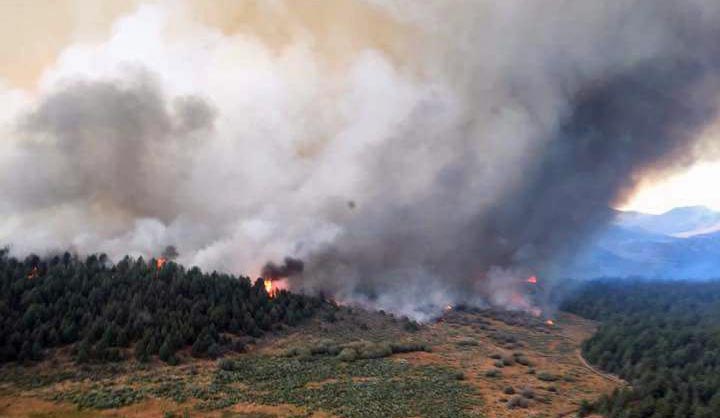
Pioneer Fire in Idaho is one of 5 fires in US with over 1,000 firefighters assigned

The Pioneer Fire was very active Monday and Tuesday.

Above: Pioneer Fire. Uncredited/undated InciWeb photo.

On Tuesday the Pioneer Fire in central Idaho continued its march to the north, adding another 16,000 acres to bring the total to over 157,000 acres. Burning 32 miles northeast of Boise and 23 miles west of Stanley, it has been creating huge convection columns rising 30,000 feet into the atmosphere for the last two days.
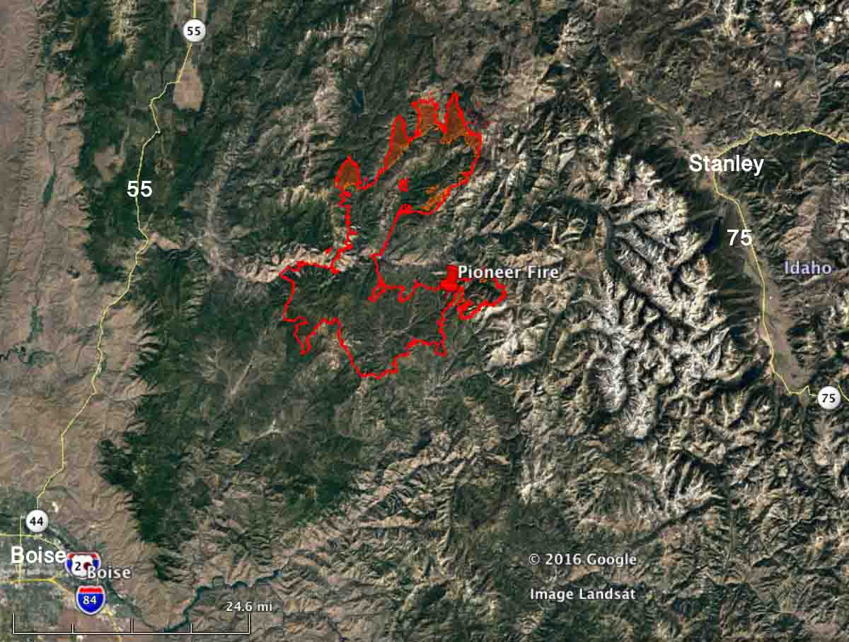
Map Pioneer Fire
Map of the Pioneer Fire at 8 p.m. MDT August 30, 2016.

Most of the growth on Tuesday was on the north side while it was pushed by an 8 to 12 mph wind gusting at 18 to 24 that was variable, but mostly out of the south. As we write this at 2:50 p.m. on Wednesday, the wind so far today has been out of the west and northwest at 4 to 10 mph with gusts of 16 to 24. The smoke being pushed to the east will probably make the air quality rather unpleasant in Stanley, due east of the fire.

The fire was very active late into Tuesday night due to the low relative humidity which ranged from 24 to 30 percent during the night at the White Hawk weather station at 8,344 feet elevation. At 2:33 p.m on Wednesday it was 66 degrees with 21 percent humidity.
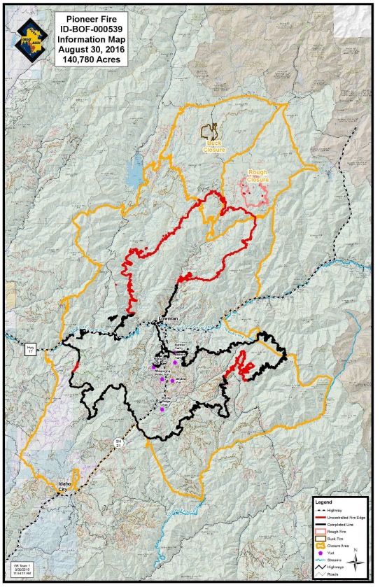
Map Pioneer Fire
Map of the Pioneer Fire August 30, 2016. The black line is completed fireline. The red is uncontrolled fire edge.

The Pioneer Fire is one of five currently active fires in the United States that are staffed by more than 1,000 personnel.

[ultimatetables 1 /]

As of Tuesday evening the total number of resources assigned to fires in the US included 444 hand crews, 1,060 engines, 147 helicopters, and 19,064 personnel. When the number of crews approaches 500 and there are almost 20,000 personnel committed, you know things are getting busy.

Updates on three California fires, Soberanes, Chimney, and Rey

Above: A firing operation on the Soberanes Fire by the Arroyo Grande Hotshots. Inciweb photo.

Soberanes Fire

This fire has been eating through the brush, grass, timber, and poison oak in the coastal mountains south of Monterey since July 22. In that time it has spread mostly to the south blackening over 91,000 acres.

Map Soberanes Fire
Map of the Soberanes Fire. The red line was the perimeter at 11 p.m. PDT Aug. 25. The white line was the perimeter at 1 a.m. PDT Aug. 7. Click to enlarge.

The only large heat sources a satellite 200 miles overhead was able to detect in the last 24 hours were near the perimeter on the south and southeast sides. The Soberanes Fire is being fought by 1,4913 personnel including 21 hand crews; 65 engines; 12 helicopters; 21 dozers; and 14 water tenders.

The fire was caused by an illegal, unattended campfire on the Soberanes Canyon trail in the Garrapata State Park. The suppression costs to date are $160 million.

Poison oak is very prevalent in the area and some firefighters are saying it is the worst they have even seen. Five hundred have reported to the fire’s medical units for poison oak related ailments, with 200 cases in the past three days.

Rey Fire

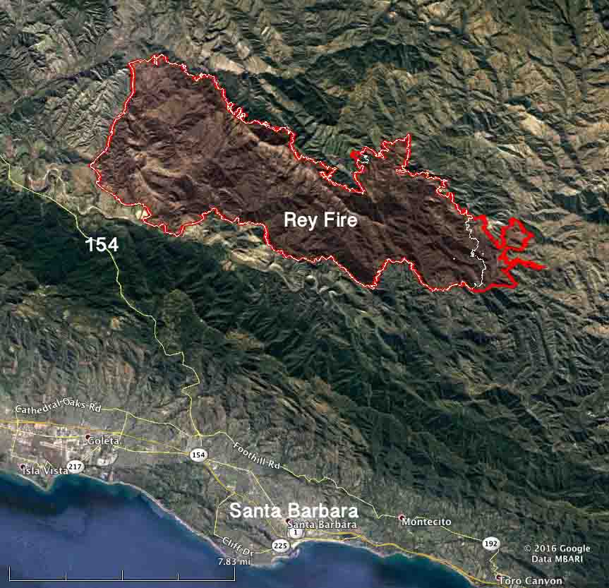
The Rey Fire north of Santa Barbara has been working its way east over the last several days but that growth has slowed as firefighters make progress by constructing direct firelines on the fire’s edge and completing contingency lines out ahead of the fire.

Map Rey Fire
Map of the Rey Fire. The red line was the perimeter at 10 p.m. PDT Aug. 25. The white line was the perimeter at 10 p.m. PDT Aug. 23. Click to enlarge.

The Rey Fire typically slows to a crawl late at night when the marine layer moves in, then the activity increases in the afternoon. The incident management team is calling it 33,006 acres. Approximately 1,976 personnel are assigned to the fire, including 57 hand crews, 99 engines, and 18 helicopters.

Chimney Fire

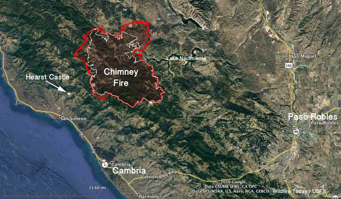
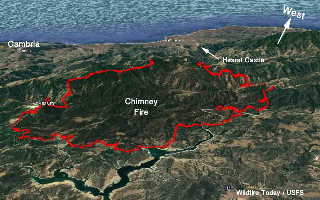
The Chimney Fire near the central California coast has continued to spread to the north over the last few days through very rough and remote country east of the Hearst Castle.

Map Chimney Fire
Map of the Chimney Fire. The red line was the perimeter at 9 p.m. PDT Aug. 25. The white line was the perimeter at 10 p.m. PDT Aug. 23. Click to enlarge.

CAL FIRE reports that 49 residences and 21 other structures have been destroyed, while 1,898 remain threatened. Some evacuation orders have been lifted but others are still in place.

The 45,000-acre Chimney Fire is being fought by 4,028 personnel, including 328 engines, 106 hand crews, 16 helicopters, 46 dozers, and 69 water tenders.

Chimney Fire grows to over 40,000 acres

Map Chimney Fire
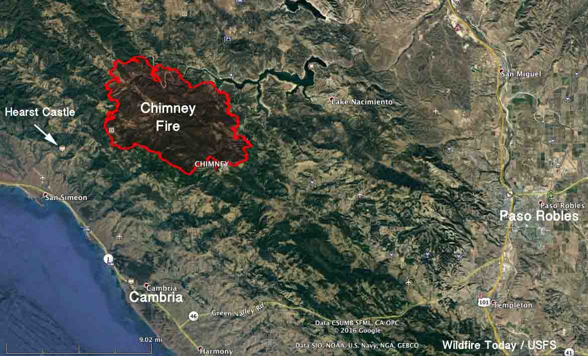
Map of the Chimney Fire at 10 p.m. MDT August 23, 2016. Click to enlarge.

Over the last two days the Chimney Fire north of Cambria near the central California coast has grown by over 10,000 acres, and has now blackened a total of 40,800 acres. Most of that expansion has been on the north side where it has moved another mile and a half into Monterey County. Late Tuesday evening and into the night it was also very active on the southwest side spreading about a mile to the southwest. It is now 2.7 miles from the Hearst Castle. Some of the additional acres on the west side are a result of firing operations by firefighters.

CAL FIRE has updated the information about the impact the fire has had on structures, reporting that 45 residences and 20 other structures have been destroyed, while 7 have been damaged.

On Tuesday the fire behavior was described as extreme after the inversion broke as usual at about 2 p.m. Firefighters have taken advantage of favorable weather conditions at night to conduct firing operations to secure firelines. One of their priorities is burning out an area on the west side that would protect the Hearst Castle.

Evacuation orders are still in place for some areas in San Luis Obispo and Monterey Counties.

(Our previous article about the Chimney Fire.)

Chimney Fire spreads into Monterey County

CAL FIRE estimates 48 structures have been destroyed

(UPDATED at 11:45 a.m. PDT August 22, 2016)

(An updated article about the Chimney Fire was published August 24, 2016)

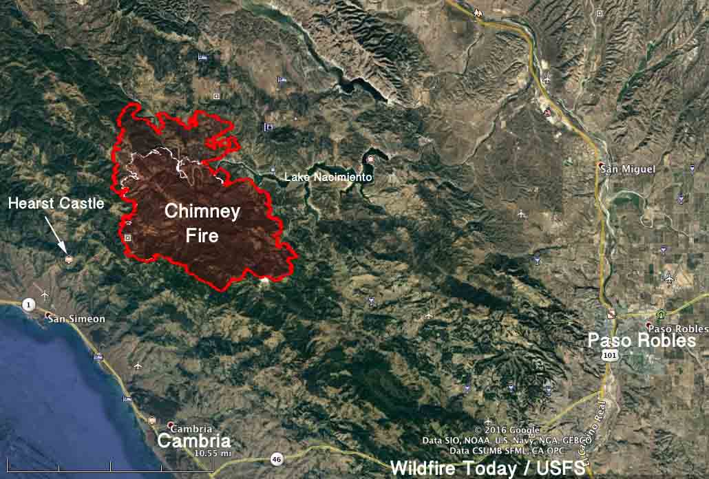
The Chimney Fire 7 miles north of Cambria near the central California coast was very active Sunday on the north and northwest sides where it spread 2.5 miles further north in about 24 hours. The fire is well established north of the western arm of Lake Nacimiento. It expanded by over 7,000 acres, growing to 31,664 acres.

Map of the Chimney Fire
Map of the Chimney Fire. The red line was the perimeter at 9 p.m. PDT August 21, 2016. The white line was the perimeter about 24 hours before.

There has been no update from CAL FIRE about the number of structures destroyed since they reported that 48 have burned and another 7 have been damaged.

Late in the day and Sunday night the fire behavior was extreme and continued to challenge the control lines. It is currently burning through the Rock Butte area and has crossed into Monterey County. After the Monday morning inversion dissipates, south and southwest winds will increase to 10 mph with gusts around 20. Snags continue to be a safety hazard for firefighters.

Evacuation orders are in place for Christmas Cove, Oak Shores, Lake San Antonio, and Bryson Hesperia affecting 2,448 people.

****

Since the Chimney Fire started on August 13 it has burned 24,096 acres 5 miles from the central coast of central California, an increase of about 8,000 acres over the previous 24 hours. It is 7 miles north of Cambria and 3 miles east of Hearst Castle, a historical landmark built in the first half of the last century by newspaper magnate William Randolph Hearst.

CAL FIRE estimates that 48 structures have burned and another 7 have been damaged. Evacuations have been ordered for some locations in San Luis Obispo and Monterey Counties.

The fire has jumped across the western arm of Lake Nacimiento.

Map Chimney Fire
Map of the Chimney Fire at 2:40 a.m. PDT Aug 21, 2016. Click to enlarge.

The spread of the fire was described as extreme on Saturday and Saturday evening. Drought-stressed timber, chaparral, and grass continue to challenge firefighters in the steep inaccessible terrain as the fire continues to move north and west.

Map Chimney Fire
3-D Map of the Chimney Fire at 2:40 a.m. PDT Aug 21, 2016.

The fire is being fought by 2,699 firefighters, 218 engines, 71 hand crews, 7 air tankers, 14 helicopters, 50 dozers, and 35 water tenders.

It is unusual to have CHAIRS and a pre-built stage for an operational period briefing.

California: Chimney Fire causes evacuations northwest of Indian Wells

(UPDATED at 2:56 PDT June 2, 2016)

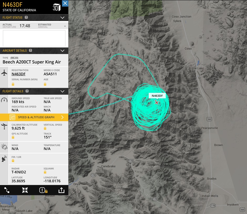
The CAL FIRE air attack ship appears to have located the Chimney Fire.

CAL FIRE Air Attack N463DF

****

(Originally published at 11:05 a.m. PDT, June 2, 2016)

Chimney Fire
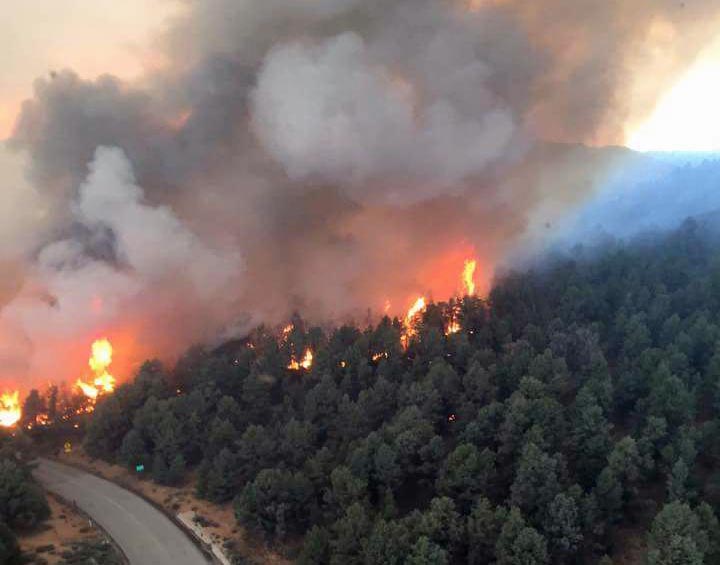
Chimney Fire, June 1, 2016. CAL FIRE photo.

The Chimney Fire has caused evacuations in the community of Chimney Rock in California. Since it started on Wednesday, it has burned approximately 1,000 acres, and is located 7 miles west of Highway 395, 15 miles northwest of Indian Wells, and 25 miles northeast of Isabella Lake.

The video below was shot on Wednesday and gives a good overview of the fire at that time.

The fire is burning on Bureau of Land Management public lands in and adjacent to the Owens Peak and Chimney Peak wilderness areas. The Pacific Crest Trail, Nine Mile Road, and Canebreak Road are closed. Approximately 300 firefighters were on scene Thursday morning.

map Chimney Fire
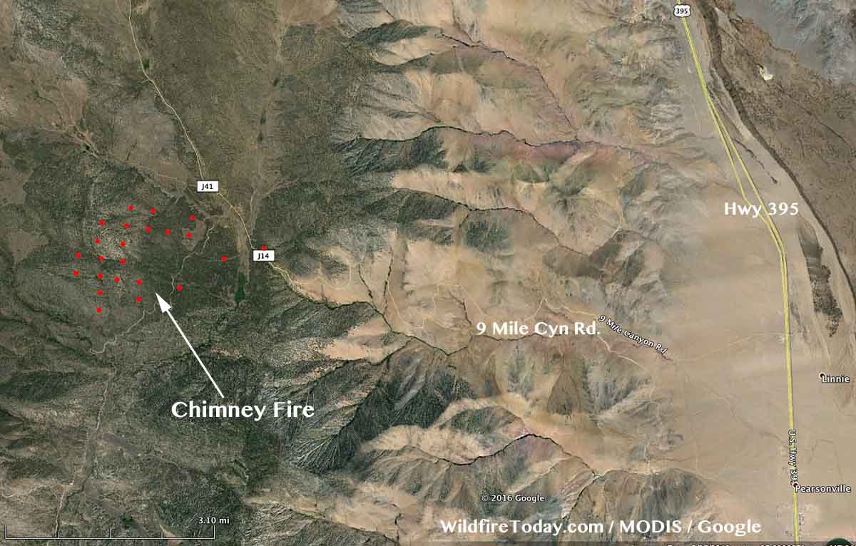
Vicinity map of the Chimney Fire.
map Chimney Fire
The red dots on the map represent heat on the Chimney Fire detected by a satellite at 2:39 a.m. PT, June 2, 2016.

The National Weather Service forecast for the fire area Thursday afternoon predicts a temperature of 73, 16 percent relative humidity, and winds out of the south and southeast at 10 mph, increasing to 10 to 23 mph out of the west and northwest after 6 p.m.

A Type 2 incident management team, with Incident Commander Mills, will assume command of the fire today.

Chimney Fire
Chimney Fire, June 1, 2016. CAL FIRE photo.