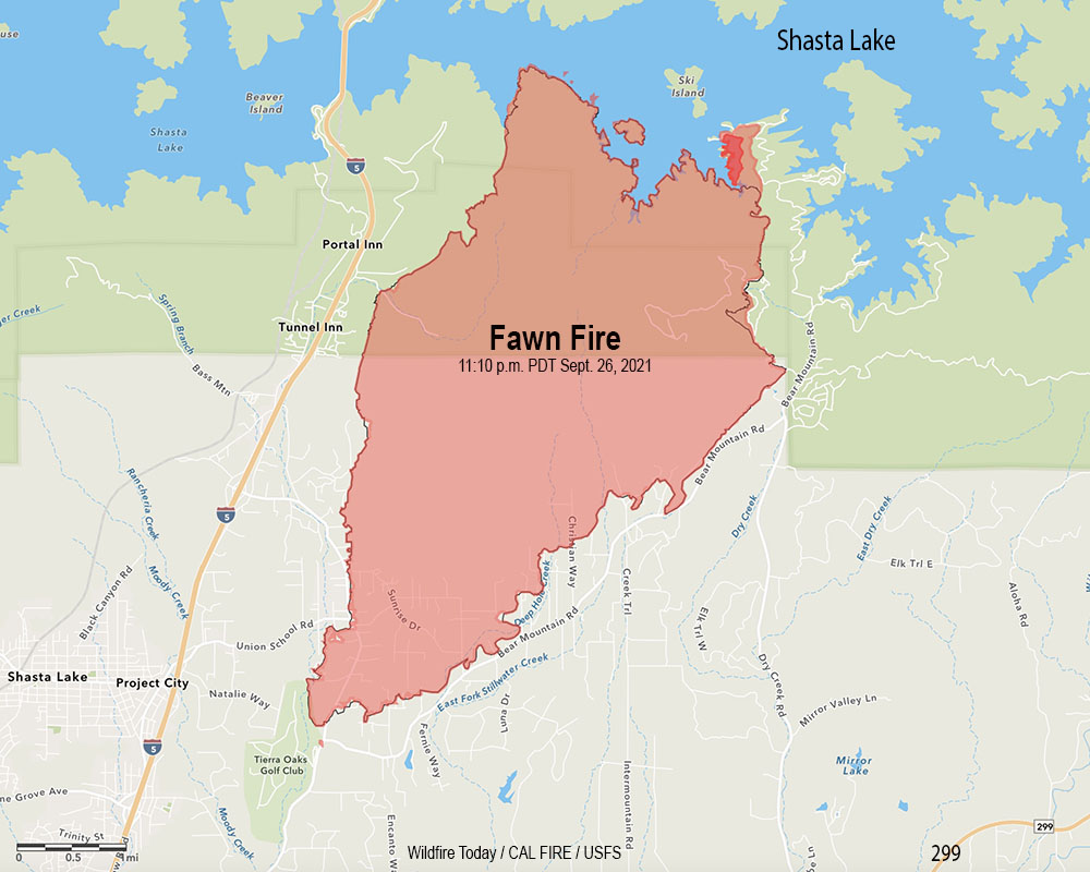
A mapping flight Monday night determined the blaze had burned 8,559 acres
8:40 a.m. PDT Sept. 27, 2021
Fawn Fire map. The outer red line was the perimeter mapped by a fixed wing flight at 11:10 p.m. Sept. 26, 2021. The blackish/red line was the perimeter about 26 hours before. The dark red area represents intense heat when the fire was mapped.
The incident management team on the Fawn Fire north of Redding, California reports that Damage Inspection Teams have documented 76 residences and 79 other structures that have been destroyed.
Shasta County has established a map showing the structures that have been evaluated for damage. Redding maintains a map showing evacuation status.
A mapping flight Monday night determined the blaze had burned 8,559 acres.
Backfiring operations near the lake on the northwest and northeast sides were both successful Sunday, stopping the spread. Firefighters now have a fireline around the entire fire, however the weather could test those lines.
Weather forecasters predict breezy conditions beginning late Monday afternoon ahead of a front which could drop 0.1″ of rain, but no wetting rains are expected. Winds will be out of the southwest gusting from 25 to 35 mph then turning to come from the northwest with gusts to 25.
A 30-year-old woman has been arrested for starting the blaze
9:18 a.m. PDT September 26, 2021
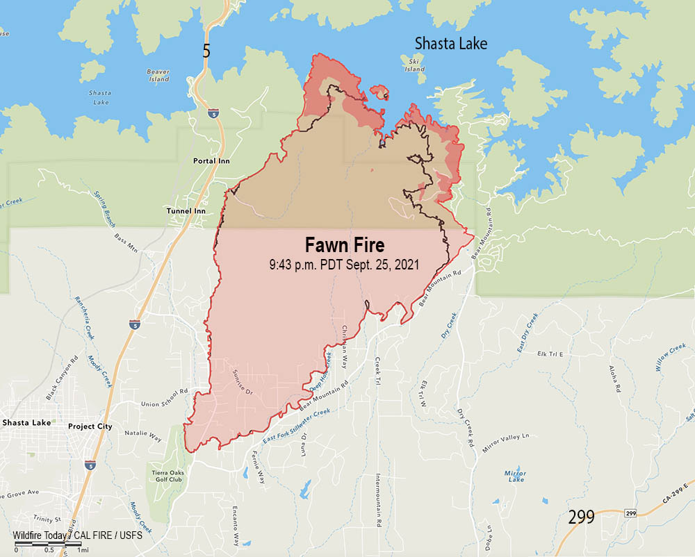
Fawn Fire map. The red line was the perimeter at 9:43 p.m. PDT Sept. 25, 2021. The black line was the perimeter about 24 hours earlier. The darker red areas indicate intense heat when the fire was mapped.
The Fawn Fire north of Redding, California grew by about 1,000 acres Saturday to bring the size up to 8,537 acres Saturday night. All of the growth was on the north side where it reached the shore of Shasta Lake west of Ski Island, and on the northeast side near Bear Mountain Lookout Road and west of Silverthorn Road.
For the second time it spotted across the lake onto an island, which is 500 to 1,000 feet away from the mainland. However with the lake as low as it is, that distance may be much shorter, or non-existent.
Below is a zoomed-in archived satellite photo overlaid with areas of intense heat in red.
North edge of the Fawn Fire, mapped at 9:43 p.m. PDT Sept. 26, 2021
Fire officials report that 131 structures have been officially documented as destroyed, with 44 of them being residences. CAL FIRE Damage Inspection Teams are still assessing the affected areas.
Starting late Monday morning, there is a chance for rain through mid afternoon Tuesday. Unfortunately, this will only produce 0.1 inch over the fire area, but the increased moisture should moderate fire behavior.
Looking toward the Fawn Fire from the Highland Trail camera pointing northwest at 9:08 a.m. Sept. 26, 2021. AlertWildfire.
Resources assigned to the fire include 12 helicopters, 201 engines, 46 dozers, 30 water tenders and 49 hand crews for a total of 1,886 personnel.
9:25 a.m. PDT September 25, 2021
Fawn Fire map 9:21 p.m. PDT Sept. 24, 2021. The dark red areas had intense heat when the fire was mapped Friday night.
The Fawn Fire has burned approximately 25 residences and 75 other structures just north of Redding, California according to fire authorities. When it started Wednesday afternoon it grew very rapidly but slowed after reaching the north-facing slopes above the shore of Shasta Lake. Friday night it was mapped at 7,544 acres and was active on the west side near Radcliff Road and on the northeast side west of Juniper Drive and Bear Mountain Lookout Road.
Saturday morning live cameras showed very dense smoke in the area which would prevent aircraft from assisting firefighters on the ground.
A map showing the evacuations that are in effect is available at the Redding website.
Friday night the fire was four miles north of Highway 299 and was east of Interstate 5 and a large powerline right-of-way east of the Interstate. It was north of Bear Mountain Road.
Alexandra Souverneva. Photo by Roseburg Police Dept..
Fire investigators arrested 30-year old Alexandra Souverneva of Palo Alto, California for starting the fire. She was booked into the Shasta County Jail charged with arson and a special allegation for starting a fire during a state of emergency.
KRCR reported that Souverneva was seen in the general area where the fire started earlier in the day. When questioned by investigators while the fire was burning she was carrying a lighter and said she was hiking because she was trying to get to Canada.
[Souverneva] said she was thirsty and had found a puddle in a dry creek bed but that it contained bear urine. She said she tried to filter the water using a tea bag but that didn’t work so she tried to start a fire to boil the water. She said it was too wet to start a fire so she drank the water and continued walking uphill.
Souverneva is suspected of starting another fire in the nearby city of Shasta Lake on September 21.
On September 12, 2021 Souverneva was arrested in Oregon, for Criminal Trespass, 2nd Degree according to the Douglas County Sheriff. She was released the following day.
The south entrance into Yellowstone National Park is still closed by the Berry Fire which is being monitored, rather than suppressed, in order to benefit the ecosystem.
On Tuesday the fire spread farther into the Bridger-Teton National Forest after burning out of Grand Teton National Park. The northeast and south sides were the most active where it moved about half a mile beyond the previous perimeter.
The red line was the perimeter of the Berry Fire at 8 p.m. MDT on August 22, 2016. The red dots represent heat detected by a satellite at 4:12 a.m. MDT August 24, 2016. Click to enlarge.
A Type 2 incident management team led by Incident Commander Tim Rodie is now in place. He is assisted by 115 personnel, which is an increase of 77 over the previous day. There are 4 hand crews, 5 engines, and 3 helicopters assigned to the fire.
The incident management team is calling the fire 6,819 acres.
****
(UPDATED at 5 p.m. MDT August 23, 2016)
The Berry Fire continued to spread Tuesday into the Bridger-Teton National Forest and the John D. Rockefeller Jr. Memorial Parkway.
US Highway 89/191/287 in Grand Teton National Park is closed at Leeks Marina on the south, and at the South Gate of Yellowstone National Park on the north.
Berry Fire. The red line was the perimeter during an 8 p.m. mapping flight August 22. The red shaded areas had the most heat at that time. The red dots represent heat detected by a satellite at 2:16 p.m. MDT August 23, 2016. Click to enlarge.
The weather recorded at the Coyote Meadows weather station 12 miles west of the fire has been fairly moderate for the last 24 hours, showing 2 to 6 mph winds out of the southwest and west and 70 degrees Tuesday afternoon. The exception to the “moderate” weather has been the relative humidity which got up to only 35 percent overnight, and at 5 p.m. Tuesday was 12 percent. That will change Tuesday night when the RH increases to 71 percent, but it will fall to 19 percent Wednesday afternoon. The wind Tuesday night and Wednesday will be out of the northeast and north at 5 to 13 mph. This could influence the fire to move to the south over the next 24 hours.
There are still no plans to put out the fire. Grand Teton National Park explained on Tuesday in a statement:
Fire management goals for the Berry Fire include providing for public and firefighter safety; suppressing fire to protect structures and campgrounds; and monitoring fire growth as it burns in wilderness and contributes to long-term forest health.
****
(Originally published at 10:14 a.m. MDT August 23, 2016)
Map of the Berry Fire. The red dots represent heat detected by a satellite at 4:31 a.m. MDT August 23, 2016. The yellow dots were detected within the previous 6 days. Click to enlarge.
The Berry Fire in Grand Teton National Park more than doubled in size Monday, closing Highway 89 which leads to the south entrance of Yellowstone National Park. The highway is closed at Leeks Marina road (south) and the Flagg Ranch (north) and will remain closed indefinitely, a park spokesperson announced Tuesday morning.
Pushed by a 5 to 8 mph southwest wind gusting up to 22 mph, the fire ran out of the park to the northeast crossing the northern tip of Jackson Lake, the Snake River, and Highway 89. It then spread into the John D. Rockefeller Jr. Memorial Parkway and the Bridger-Teton National Forest. Lizard Creek Campground has been evacuated.
3-D Map of the Berry Fire looking north. The red dots represent heat detected by a satellite at 4:31 a.m. MDT August 23, 2016. The yellow dots were detected within the previous 6 days. Click to enlarge.
The rapid fire spread on Monday added about 3,800 acres, bringing the size of the Berry Fire up to approximately 6,900 acres as of 4:31 a.m. on Tuesday.
Motorists expecting to enter Yellowstone from the popular south entrance will be forced to take long detours stretching for hundreds of miles. They may not be pleased to learn that National Park Service officials decided on July 25 when the Berry Fire started to allow the fire to “enhance the area’s natural resources”, rather than suppress it.
The moderately strong winds that caused the fire to leave Grand Teton National Park were accompanied Monday by 7 percent relative humidity and 80 degree temperatures.
Highway 89 south of Yellowstone’s south entrance remains closed due to fire. At this time, there is no estimated time of opening.
Grand Teton National Park brought in a Type 3 incident management team for the fire on August 21 when Red Flag Warnings for extreme wildfire danger appeared in the weather forecast. At that time there were 25 personnel assigned. As of August 22 that had increased to 39. Eight fires listed on the August 23 National Situation Report have more than 500 personnel assigned. Five have more than 1,300. However, those fires are larger and are threatening more structures.
Now that the fire has closed Highway 89 and burned outside the park they have ordered a higher level team, a Type 2 team to manage the fire, with Incident Commander Tim Roide. The next level up would be a Type 1 team.
Wildfires in Yellowstone NP and Grand Teton NP. The red areas represent heat detected by a satellite at 4:31 a.m. MDT August 23, 2016. The yellow areas were detected within the previous 6 days. Click to enlarge.
There are three active fires in Yellowstone National Park, the Maple, Fawn, and Buffalo fires. We covered these earlier. They all continued to spread on Monday. The Maple fire east of West Yellowstone, Montana marched another mile to the north, but was active on most of the perimeter. The park says all roads and businesses remain open, including the east and west entrances and the highway that goes right by the Maple Fire, Highway 20.
Earlier on Monday we repeated the information provided by the National Park Service that the roads in Yellowstone National Park remained open, in spite of the five ongoing fires in that park and just to the south, Grand Teton National Park. That changed Monday evening.
1 of 3 – Berry Fire causes temporary road closure of highway 89 between Leek’s Marina on south and Flagg Ranch on north.
See the map below. The Berry Fire is in the north end of Grand Teton NP just south of the south entrance into Yellowstone NP. Highway 89 is the only way to enter Yellowstone on the south.
Normally from Moran, WY to Yellowstone Lake at Lake, WY, it is a 68 mile trip. With Highway 89 closed, detouring to the east would be a 344-mile journey. Detouring to the west would be 213 miles.
There are five wildfires burning in Yellowstone and Grand Teton National Parks in Wyoming and Montana, which together have burned over 28,000 acres. Four are being managed with a less than full suppression strategy, while one was aggressively attacked and has not been very active in the last 24 hours.
Northwest Wyoming is under a Red Flag Warning on Monday.
Officials in Yellowstone National Park emphasize that all roads leading into and through the park are open. Park visitor facilities, including park concession-operated services and businesses in the surrounding communities are not impacted by the fires and remain open.
Fires in Yellowstone and Grand Teton National Parks, showing heat detected by a satellite. The red dots represent the most recent, seen at 3:11 a.m. MDT August 22, 2016.
Yellowstone National Park fires
Fawn Fire, 1,496 acres in the northwest corner of the park. Since it started August 4 it has been intermittently active and has been spreading during the last two days.
Maple Fire, 22,448 acres 4 miles east of West Yellowstone, Montana. It was first reported by personnel in a smokejumper aircraft passing over the park. The fire has come very close to US Highway 20, but has not crossed it. The highway leads to the west entrance into the park. The fire has been active on most of its perimeter over the last 24 hours. Should smoke or fire activity increase, pilot cars may be used to safely escort vehicles through the area.
Buffalo Fire, 2,279 acres, in the north-central part of the park, 3 miles northeast of Tower Junction (US Highway 212 and the Grand Loop Road) and half a mile south of the park’s northern boundary. The recent activity has been on the north edge of the fire. Since it was reported on August 13 it has been managed under a combination of monitoring and point-protection strategies.
Boundary Fire, 192 acres in Montana 5 miles north of West Yellowstone, Montana and very close to the park’s western boundary. Park personnel have actively suppressed this fire, and it has not been very active in the last 24 hours. A smaller Incident Management Team, a Type 4 team, assumed command Monday morning. Firefighters are mopping up and removing hazardous trees within the perimeter.
Grand Teton National Park
Berry Fire, 1,785 acres in the north end of the park, one mile west of the northern end of Jackson Lake, and 2 miles west of Highway 89 (providing photo opportunities for passing tourists). The fire has been active over most of its perimeter during the last 24 hours. It has been burning for almost a month and is now being managed by a Type 3 Incident Management Team which is planning for the expected growth of the fire. An objective of the Team is to “enhance the area’s natural resources where appropriate”. They further state, “The fire will be monitored and management actions will be implemented in advance of any potential impact on values at risk.” The fire has not required the closure of any roads.