The time-lapse video shows the Fort McMurray Fire (Horse River Fire) in Alberta burning up to the city’s airport. The fire has blackened over one million acres.
Tag: Fort McMurray
Fort McMurray Fire as seen from space
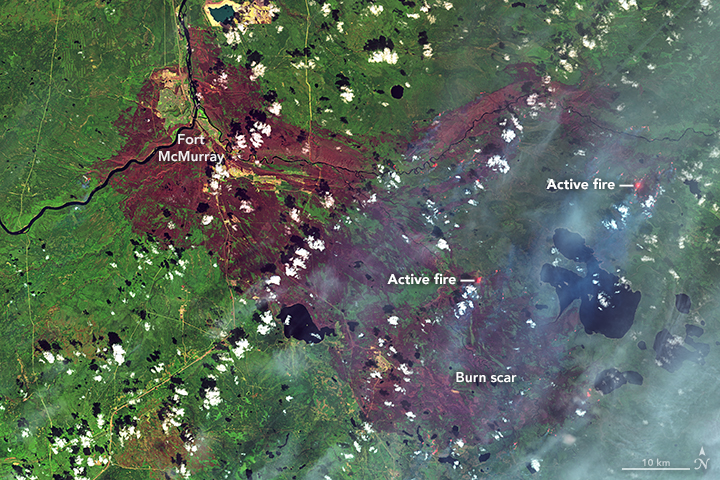
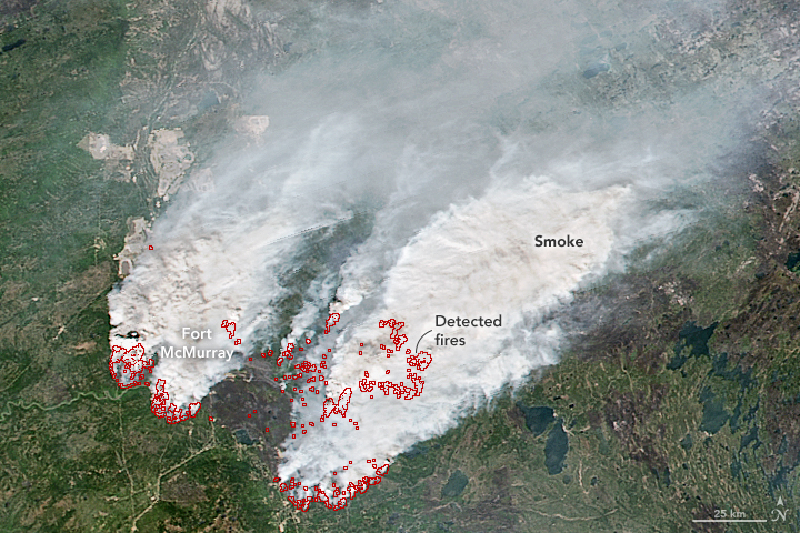
NASA provided these images of the wildfire at Fort McMurray (Horse River Fire) in Alberta as seen from the Landsat 8 satellite. The one above was acquired on May 12, a day when there was little activity on the fire. In contrast to that, check out the image below taken on May 16 when conditions were very different.
Our most recent comprehensive article about the Fort McMurray Fire is HERE.
Fort McMurray Fire spreads into Saskatchewan
(UPDATED at 10:40 a.m. MDT, May 19, 2016)
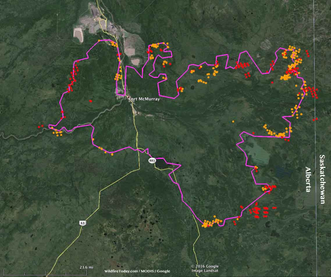
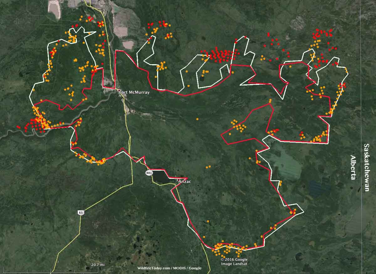
The Fort McMurray Fire (Horse River Fire) was not as active Wednesday as it has been in the preceding three days, but it did move east several kilometers and crossed the boundary from Alberta into Saskatchewan.
The weather forecast through Sunday calls for more moderate conditions and a good chance of rain on Thursday, Saturday, and Sunday. Next week should be clear and warmer.
****
(UPDATE at 8:50 a.m. MDT, May 18, 2016)
Noralta Camp with fire on the doorstep. Stan Laurent CEO Ft. McKay Enterprises video credit. #ymmfire #ymm pic.twitter.com/LigSMRDPFM
— Karen Lavallee (@OceanViewBC) May 17, 2016
Above: Video of the Fort McMurray Fire approaching the Noralta Camp, shot by CEO Ft. Mckay Enterprises.
The Fort McMurray Fire (Horse River Fire) has enlarged its footprint over the last two days to 422,898 hectares (1,045,022 acres, 1,632 square miles). On May 16 it was mapped at 284,000 hectares (702,000 acres, 1,097 square miles). The east side of the fire is approximately 3 miles (5 kilometers) from the Saskatchewan border.
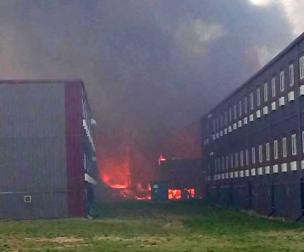
On Tuesday the fire reached the Black Sands Camp and burned the Executive Lodge with its 665 units in spite of the building’s sprinkler system. It next spread to the Noralta Camp that houses 3,000 people, but at the last report firefighters held the fire at bay with no damage to the structures.
Two houses recently exploded in Fort McMurray, damaging ten other nearby homes. The causes are unknown.
The warm, dry weather that has contributed to this growth will continue today with a high temperature at Fort McMurray of 75 °F, a relative humidity of 28 percent, west winds at 8 to 12 mph, and partly cloudy skies. That will change on Thursday when it should be 20 °F cooler with an RH above 60 percent, and a 50 percent chance of rain.
Continue reading “Fort McMurray Fire spreads into Saskatchewan”
Owners watched on their smart phone as their Fort McMurray home burned
The homeowners gave Storyfull News permission to post this video. Apparently the home in Fort McMurray, Alberta had a security camera with a live feed over the internet.
More information about the huge fire at Fort McMurray, Alberta that at the last count has burned about 1,600 structures and 387,000 acres (157,000 hectares).
The Red Cross is accepting donations to assist the victims of the fire that tore through Fort McMurray
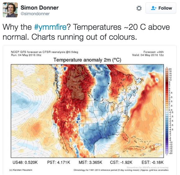
Tuesday’s weather in Fort McMurray was 8 degrees above record high for the date
“#ymmfire” refers to the airport code for the Fort McMurray International Airport in Alberta. The entire population of the city, more than 80,000, was ordered to evacuate when it became obvious it was going to be overrun by the fire.
More information about the fire.
Below is an excerpt from a May 4, 2016 article at Slate about the weather in Canada:
…Canada’s northern forests have been burning more frequently over recent decades as temperatures there are rising at twice the rate of the global average. A 2013 analysis showed that the boreal forests of Alaska and northern Canada are now burning at a rate unseen in at least the past 10,000 years. The extreme weather of recent months is also closely linked with the ongoing record-setting El Niño conditions in the Pacific Ocean, which tends to bring a warmer and drier winter to this part of Canada. Last month, Canadian officials mentioned the possibility of “large fires” after over-winter snowpack was 60 to 85 percent below normal and drought conditions worsened.
This week, a strong atmospheric blocking pattern—a semi-stable extreme arrangement of the jet stream—reinforced an unseasonable heat wave and helped temperatures reach 90 degrees Fahrenheit (32.2 degrees Celsius) on Tuesday in Fort McMurray, 40 degrees Fahrenheit above normal, eight degrees above the daily record high, 15 degrees warmer than Houston, and the same temperature as Miami. While fleeing, some evacuees had to turn on their air conditioners…

