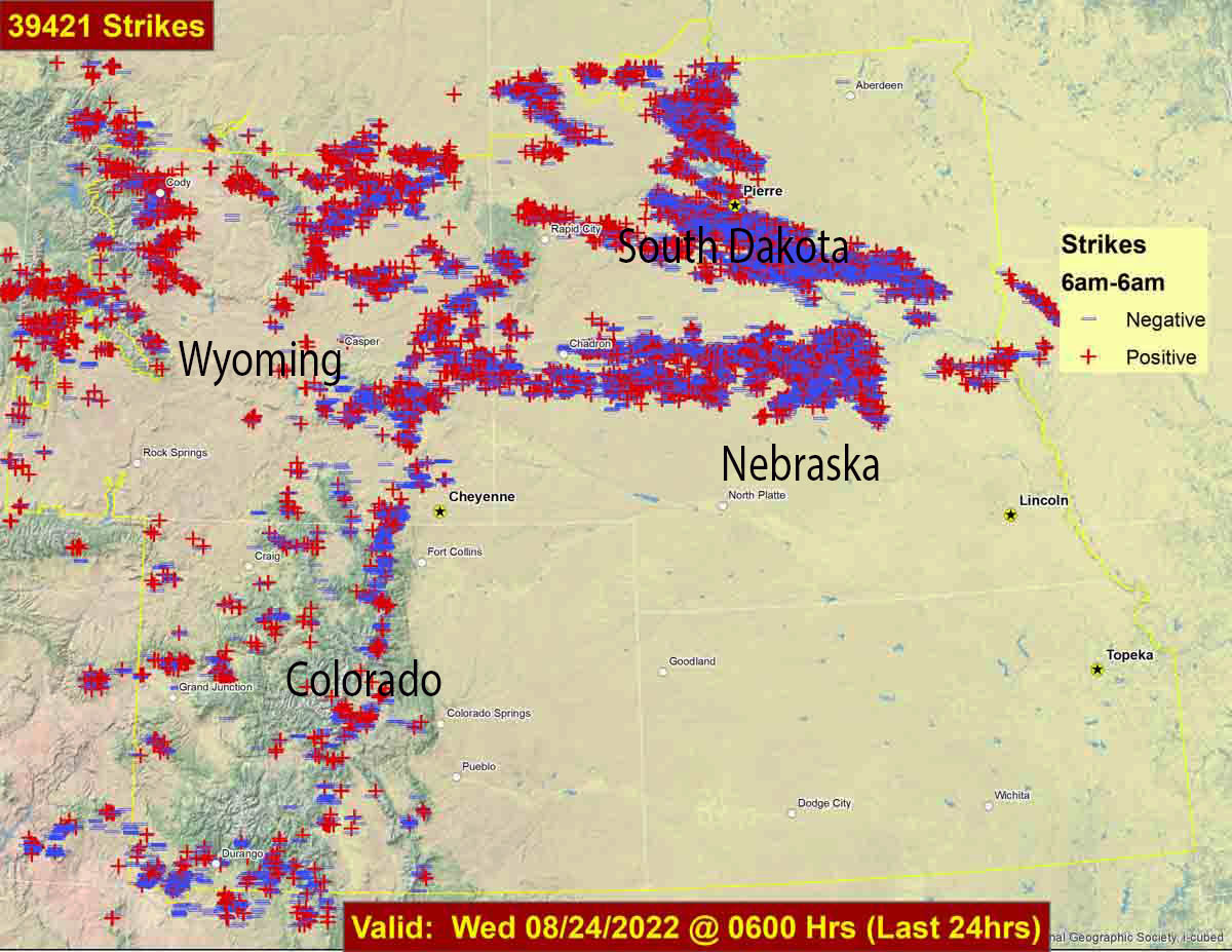
Lightning strikes during 24-hour period ending at 6 a.m. Aug. 24, 2022. Lightning strike data from Rocky Mountain Area Coordination Center.
During the 24-hour period ending at 6 a.m. Wednesday 39,421 lightning strikes were detected in parts of Wyoming, Colorado, South Dakota, and Nebraska. In many areas there was not a great deal of rain accompanying the lightning.
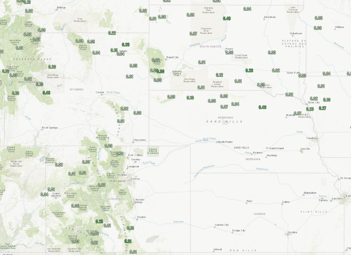
Precipitation during 24-hour period ending at noon Aug. 24, 2022.
The weather forecast for Cheyenne, Wyoming on Wednesday is for 84 degrees, 12 mph winds out of the southeast, 30 percent cloud cover, and 22 percent relative humidity.
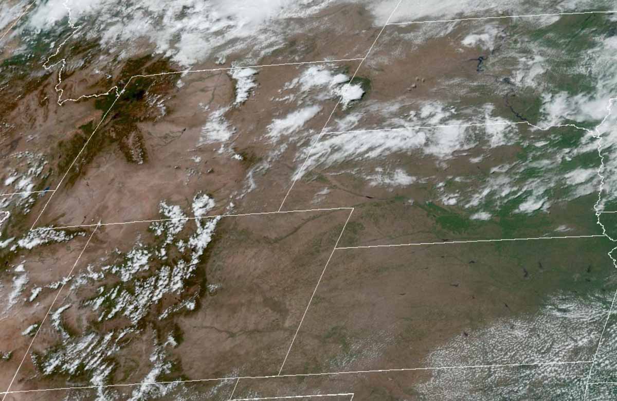
The satellite photo taken at 11:56 a.m. MDT on Wednesday shows partly cloudy skies over the general region.
Researchers studied the climatology of dry lightning in California
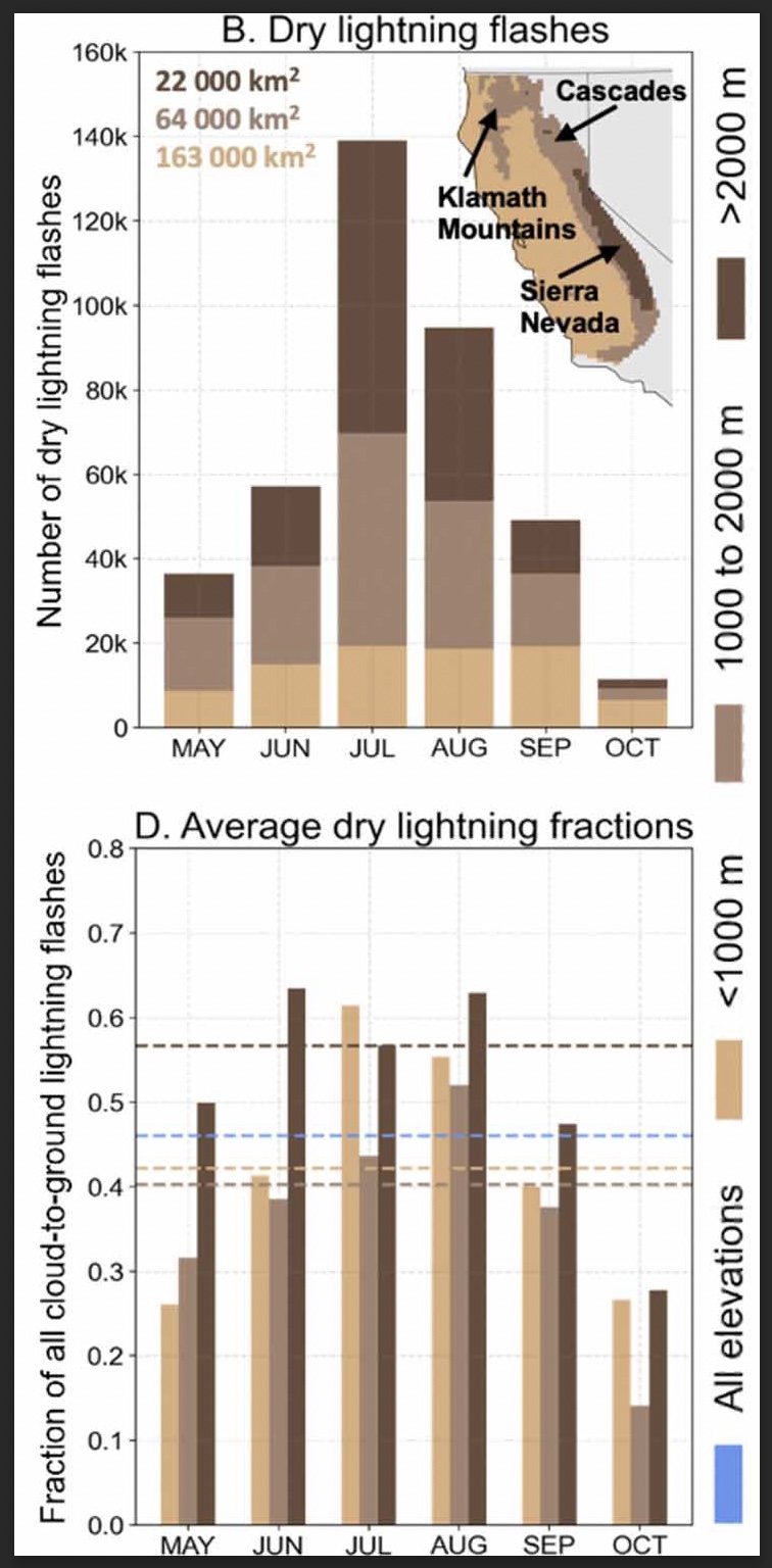
(B) Total number of dry lightning flashes across three elevation zones (<1000 m, 1000–2000 m, >2000 m) within the domain for each month between 1987–2020. Text indicates the area of each elevation zone, and inset map shows the geographic distribution of the elevation zones and major mountain ranges. (D) The three elevation zones for each month (bars). Dashed lines in (D) indicate the dry lightning fraction averaged across all months for each zone. Blue dashes in (D) represent the dry lightning fraction computed from all months and elevation zones. (From the paper)
A group of six researchers who studied the occurrence and characteristics of cloud to ground lightning in Central and Northern California found that nearly half, 46 percent, was dry, accompanied by less than 0.1 inch of precipitation.
Of course dry lightning is the bane of land managers and is much more likely to ignite a wildfire than a wet thunderstorm. And on the occasions when there are thousands of down strikes, it can overwhelm the capacity to suppress what can be hundreds of fires.
The six scientists used daily gridded lightning and precipitation observations (1987–2020) in combination with atmospheric reanalyses, to characterize the climatology of dry lightning and the associated meteorological conditions during the warm season (May–October) when wildfire risk is highest.
The paper the group produced is available as open source: “Meteorological and geographical factors associated with dry lightning in central and northern California.”
Daniel Swain, a prolific user of Twitter, used the platform today to highlight some of the group’s findings. In the tweet below, click on “read reply” to see more discussion and illustrations.
We assess regional-scale atmospheric conditions favorable for dry lightning in central & northern California (N&C CA), as well as seasonality. We find that nearly half of all lightning strikes in N&C CA are “dry” (accompanied by <0.10 in. of rain). (2/n) https://t.co/DkooDBG0ggpic.twitter.com/1eZpRIG9cX
The six researchers who participated in the project were Dmitri A. Kalashnikov, John T. Abatzoglou, Nicholas J. Nauslar, Daniel L. Swain, Danielle Touma, and Deepti Singh.
A woman and her two dogs were killed by lightning in Pico Rivera
8:15 a.m. PDT June 24, 2022
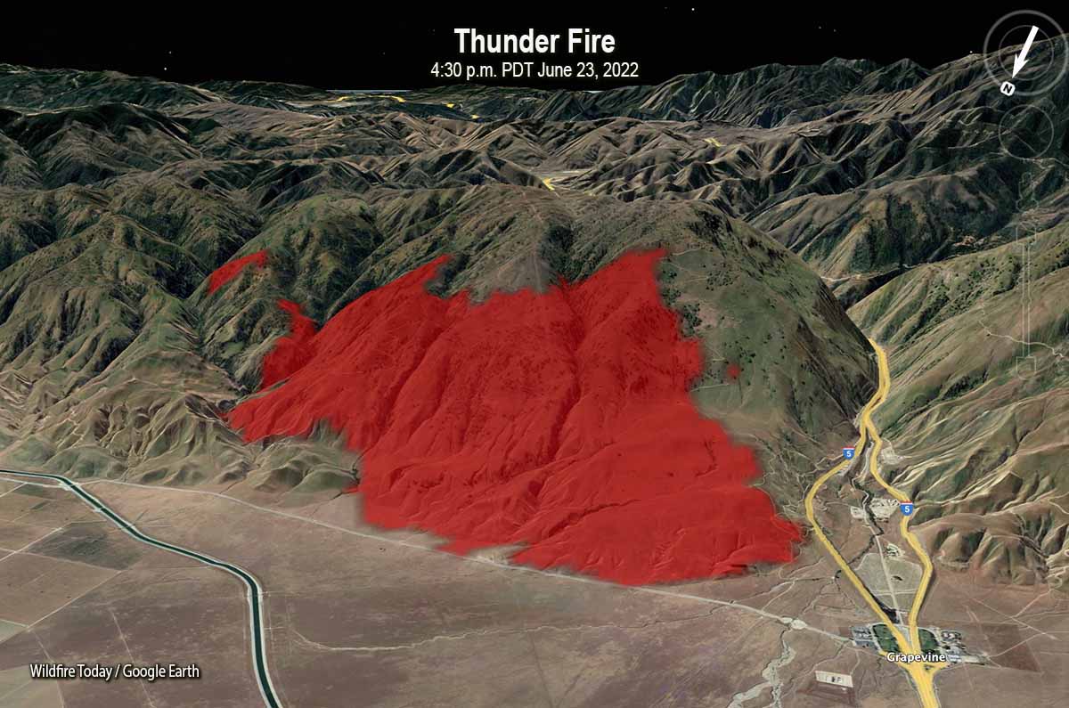
Map of the Thunder Fire, 4:30 p.m. PDT June 23, 2022, near the Grapevine on Interstate 5 in Southern California. Looking south-southeast
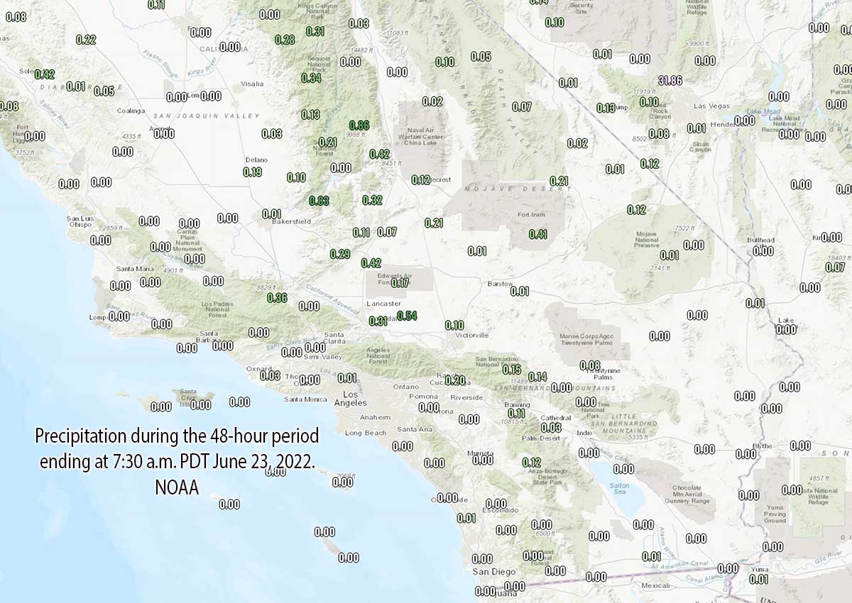
It is still possible that some of the 50,000+ lightning strikes in California on Wednesday and Thursday could have started fires that are undetected, very small, and smouldering, but so far most of the blazes that have been reported have been contained, or very close to it. The lack of numerous huge fires in the wake of the lightning is likely due to the rain that accompanied the strikes in some areas, high relative humidity, and it being fairly early in the fire season before fuel moistures drop to critical levels.
The largest has been the Thunder Fire (see map above) just west of the Grapevine on Interstate 5 north of Frazier Park. The official cause has not yet been released, but lightning is suspected said Captain Andrew Freeborn of the Kern County Fire Department. Friday morning it was 2,466 acres and had 311 personnel assigned.
The Romero Fire was reported Thursday afternoon in Merced County near Santa Nella, five miles south of Highway 152. As of early Friday morning it had burned 422 acres of grass and is 100 percent contained. The cause has not been released.
Five other fires in the greater Bay Area have burned 26 to 522 acres; firefighters so far have not had much difficulty in stopping the spread of those incidents.
On Thursday the reported wildfire activity in Southern California was, CAL FIRE, 33 fires; County and local, 14 fires; and US Forest Service, 6 fires. It is not known how many of these can be attributed to lightning.
7:42 a.m. PDT June 23, 2022
Lightning, during the 24 hours ending at 6:15 a.m. PDT June 23, 2022. LightningMaps.org
As monsoonal moisture moved through Southern California Wednesday more than 50,000 lightning strikes were detected, starting wildfires and killing a woman and her two dogs who were walking in Pico Rivera.
Chris Vagasky, @COweatherman, tweeted that a total of 54,329 strikes were recorded across California on Wednesday UTC time.
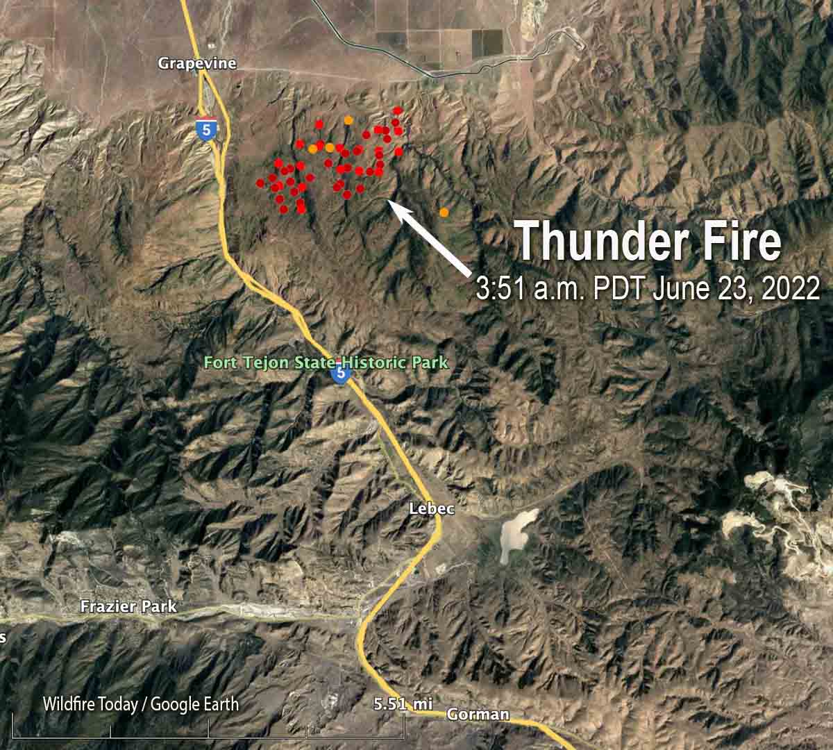
Map showing heat detected on the Thunder Fire by satellites as late as 3:51 a.m. MDT June 23, 2022.
Multiple fires suspected of being started by lightning occurred in Southern California, with most of them being suppressed while very small. The cause of the Thunder Fire east of Interstate 5 near the Grapevine north of Frazier Park is under investigation, but the suspected cause is lightning, said Captain Andrew Freeborn of the Kern County Fire Department. At 6:45 a.m. Thursday the Department reported it had burned approximately 2,300 acres and was being staffed by 250 personnel.
Small fires on the Angeles National Forest were being worked overnight by firefighters assisted by night-flying helicopters.
Lightning during the 24-hour period ending at 6:44 a.m. PDT Sept. 10, 2021. The red strikes are the most recent.
Lightning, strong winds, and showers moved into California, Nevada, and Oregon Thursday afternoon. Friday morning at about 7 a.m. the National Weather Service reported approximately 1,100 ground strikes had occurred in California.
Most of Northern California and Central Oregon received at least a small amount of rain. While some weather stations recorded none or less than 0.05″ others measured more than 0.25″.
Precipitation, Western US, 24 hours ending at 7:10 am PDT Sept. 10, 2021.
All of the precipitation amounts below are for the 24-hour period ending at 7:10 a.m. PDT Sept. 10.
Maps of precipitation in California and Oregon–
Precipitation, Northern California, 24 hours ending at 7:10 am PDT Sept. 10, 2021.Precipitation, Oregon, 24 hours ending at 7:10 am PDT Sept. 10, 2021
This video of a lightning-struck tree burning is mesmerizing. Michael Bogan of the University of Arizona filmed it July 31 in Southern California near Big Bear Lake. The US Forest Service responded, Mr. Bogan said, and suppressed the fire.
The Lolo National Forest in Montana reported two new fires Wednesday night exhibiting crowning and spotting fire behavior
9:42 a.m. MDT July 8, 2021
Lighting, 24 hours previous to 7:59 a.m. MDT July 8, 2021.
Wednesday’s lightning that battered parts of Washington, Idaho, Montana, Wyoming, and South Dakota came with little or no precipitation.
Wednesday night the Lolo National Forest west of Missoula, MT reported that they were working on three new fires, including two that were each 30 to 50 acres and exhibiting crowning and spotting fire behavior.
Thursday afternoon there could be more thunderstorms in Western Montana, some of which could become severe with powerful wind and large hail. Gusty winds across the state will elevate the fire danger. The forecast for Helena calls for 13 to 16 mph winds gusting out of the northwest at 20 to 28 mph with relative humidity in the teens.
Precipitation, 24 hours previous to 8:40 a.m. MDT, July 8, 2021.Red Flag Warnings, July 8, 2021
From the Idaho Panhandle National Forests, Wednesday evening, July 7:
Widespread lightning, accompanied by very little precipitation, moved through overnight impacting the Idaho Panhandle National Forests and the greater region. Numerous fires have been reported and confirmed. The fires are all currently in the initial attack phase with an all-hands-on-deck interagency response. In addition to engines, water tenders, hand crews, and helicopters, large air tankers are also supporting fire managers with 3,000 gallon loads of retardant loading from the Coeur d Alene Tanker Base.
More information will be available as management shifts from initial attack into extended attack, if needed.
Air tankers at Pappy Boyington Field in Coeur d’Alene, Idaho, July 7, 2021. USFS photo.