Oregon county changes zoning to require new construction to be low density

Structures farther apart are less likely to ignite neighboring homes during a wildfire

Deschutes County in Oregon has approved new zoning that will require new construction on the west side of Bend to be low density and fire-resistant.

Oregon Public Broadcasting reports that the new regulation will result in 90 percent fewer homes in the area than the previous code permitted.

One contributing factor that led to more than 15,000 homes being destroyed in two fires in California in 2018, the Camp and Carr Fires, was the close spacing between the structures.
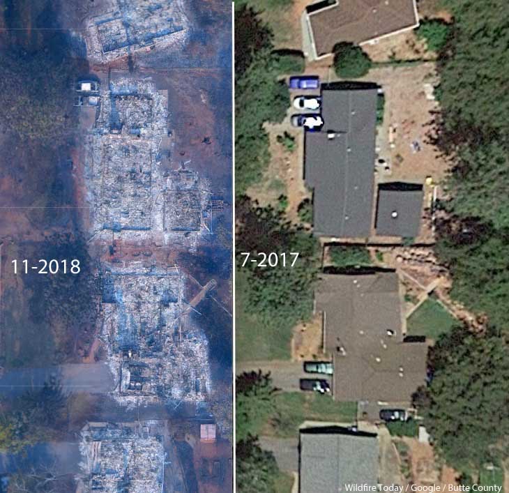
Paradise Camp fire homes burned
A neighborhood on Debbie Lane in Paradise, California, before and after the Camp Fire that started November 8, 2018. The homes were 14 to 18 feet apart.

Cities, counties, and planning boards (where they exist) are often under pressure to approve new housing developments. They want to expand their tax base. Developers try to fit as many homes into a new subdivision as possible to maximize their investment. This too often results in homes that are 20-feet apart. If one is ignited by a burning ember that may have traveled a quarter of a mile from a fire (or a burning home) the radiant heat alone can ignite the homes on both sides. Then you can have a self-powered conflagration spreading house to house through a city. As long as the structures are that close together, the homeowners have not reduced the fuel in the Home Ignition Zone within 100 feet of the structure, and the home itself is not built to FireWise standards, a massive disaster can be the result.

Reducing the chances that a fire in a populated area will turn into a disaster that burns thousands of homes involves at least three categories of factors, in addition to weather:

  • Envelope of the structure itself: characteristics of the roof, vents, siding, doors, windows, foundation, fences, eaves, and decks. A FEMA publication (13 MB) has excellent detailed recommendations. Headwaters Economics found that the cost of building a fire-resistant home is about the same as a standard home.
  • Home Ignition Zone — topography and fuel within 100 feet.
  • Community infrastructure and planning: distance to nearby structures, evacuation capability, safety zones, road and driveway width, turnarounds at the end of roads, signage, and emergency water supply. Again, the FEMA document has great recommendations.

More information about how to prevent wildfires from wiping out communities.

Thanks and a tip of the hat go out to Kelly.
Typos or errors, report them HERE.

A physician describes “smoke induced depression” in Oregon

Terwilliger Fire
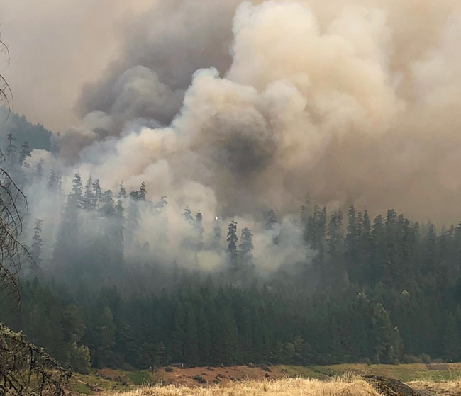
Terwilliger Fire in western Oregon, August 24, 2018. Inciweb photo.

The Mail Tribune posted a video about how in recent years the occurrence of wildfire smoke seems to be more frequent in Oregon.

Some of the short term effects of smoke are well known, such as how it can affect people with pre-existing respiratory conditions, but not much research has been completed on the long term effects on residents or firefighters.

In the video, Doctor of Nursing Practice Matt Hogge introduced a condition called smoke induced depression.

“You see a lot of people coming in with mild mental health concerns”, he said, “that might not have those in their day to day life, but the anxiety of not being able to go outside and do the things that they are normally able to do really affects some people’s moods.”

Report of “extreme spotting” 6 miles ahead of Klondike Fire

(Originally published at 5:34 a.m. PDT October 17, 2018)

Typically by mid-October firefighting agencies in Oregon have downsized their ranks of seasonal firefighters and are preparing to enter winter mode. But the Klondike Fire west of Grants Pass, after being dormant for weeks, exploded back to life on October 14 and in a big way. Within a matter of hours it burned an additional 4,968 acres to bring the total up to 172,287 acres.

According to an article in the Mail Tribune it was transporting burning embers into the atmosphere that started fires six miles out ahead of the flaming front:

“Extreme spotting” propelled fine embers up to six miles ahead of the main fire, dropping the live ash right between firefighters’ tents and close to people’s homes.

“We even had to move our own fire camp,”  [information officer Kale] Casey said.

The map below shows spot fires detected by an infrared mapping flight.

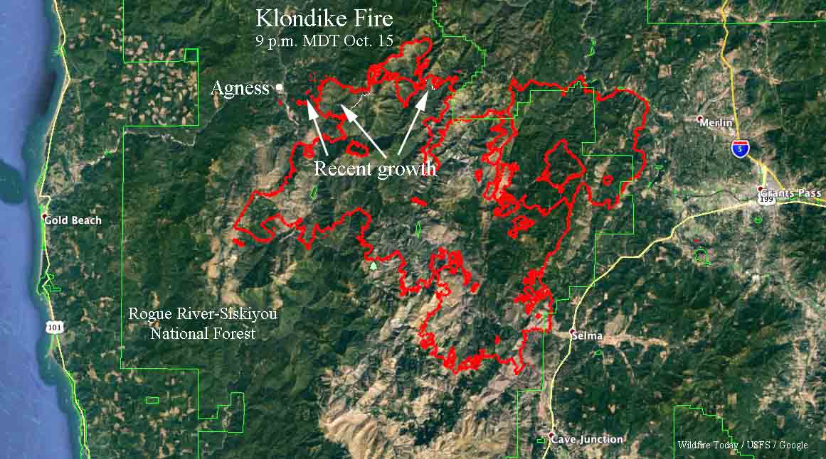
map Klondike Fire
The red line on the map was the perimeter of the Klondike Fire at 9 p.m. October 15, 2018. The white line shows where the perimeter was before the October 14-15 additional growth. Click to enlarge.

The Incident Management Team posted an update on Tuesday October 16:

Fire personnel focused all efforts to ensure that Sunday’s wind driven spot fires did not damage any of the homes in the Oak Flats, Spud Road and Agness area. Fire managers estimate that the weekend wind event resulted in approximately 5,000 acres of new growth to the west of the primary containment lines. Level 3 evacuations remain in effect for these areas while fire crews and engines work to construct and link together new and existing containment lines.

The Oregon State Fire Marshal’s five structural task forces that arrived yesterday have split into day and night shifts to ensure that all homes under evacuation are protected. These resources include twenty engines and five water tenders with firefighters from thirty-three different fire agencies from across the state.

Fire behavior moderated significantly yesterday as the 30 mph winds over the weekend diminished significantly, allowing fire firefighters to attack spot fires directly. Containing the remaining spot fires east and west of the Illinois River and west of the 3577 Road is the primary objective for all fire personnel.

Warm, dry, breezy weather awakens Klondike Fire in Southwest Oregon

After being relatively quiet for weeks the fire jumped firelines Sunday requiring evacuations in Agness

(UPDATED at 5:10 a.m. PDT October 16, 2018)

map Klondike Fire
The red line on the map was the perimeter of the Klondike Fire at 9 p.m. October 15, 2018. The white line shows where the perimeter was before the October 14-15 additional growth. Click to enlarge.

The map of the Klondike Fire above is a result of mapping by a fixed wing aircraft at 9 p.m. PDT October 15. The new growth on October 14 and 15 added another 4,968 acres to bring the total up to 172,287 acres.

The weather forecast for the fire area on Tuesday (Agness, OR) predicts a high temperature around 80, relative humidity in the teens, and 5 mph east to northeast winds. The area is not under a Red Flag Warning.


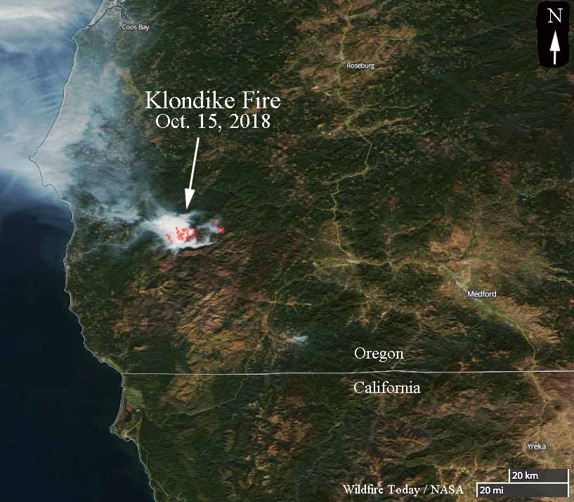
Klondike Fire in southwest Oregon
A satellite photo taken October 15 showing heat (the red dots) and smoke on the Klondike Fire in southwest Oregon.

The Klondike Fire had been quiet for weeks until warm, dry, breezy weather on Sunday brought it back to life, burning thousands of acres outside the firelines and requiring evacuations in the small town of Agness 20 miles northeast of Gold Beach, Oregon. The Sheriff’s Office in concurrence with fire officials  made the determination that evacuations were appropriate for residents north of the Rogue River and in the areas of Oak Flat, Spud Road, and along the 33 road in Agness.

Incident Management Teams had released 171 fire personnel over the last seven days, to bring the total down to 316. The 167,423-acre fire had not increased in size for over a week. Approximately 250 additional resources have been requested, including aircraft, engines, and Type 1 Interagency Hotshot Crews (IHC). Northwest Incident Management Team 7 (NWIMT7) assumed command of the October 14, 2018 at 8:00 p.m.

The Oregon Governor has declared the Klondike Fire to be a “conflagration”which allows the State Fire Marshal to mobilize firefighters and equipment to assist local crews.

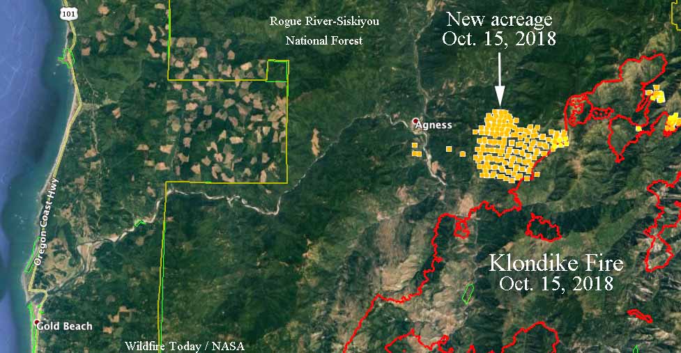
map Klondike Fire
The red line on the map was the perimeter of the Klondike Fire the last time it was mapped, on October 12, 2018. The yellow dots represent heat detected by a satellite at 4:54 a.m. PDT October 15, 2018. We will update this map when new data becomes available.

At 2 p.m. Monday afternoon a weather station near Agness recorded 73 degrees, 10 percent relative humidity, and 2 mph SSE winds. The maximum wind gust over the previous 24 hours was 20 mph Sunday evening.

Our very unofficial analysis of Sunday’s activity indicates that approximately 4,500 additional acres burned on the northwest side of the fire east of Agness. Firefighters have requested a Monday night infrared mapping flight to get a more accurate assessment.

Technology increasingly being used by firefighters in Oregon

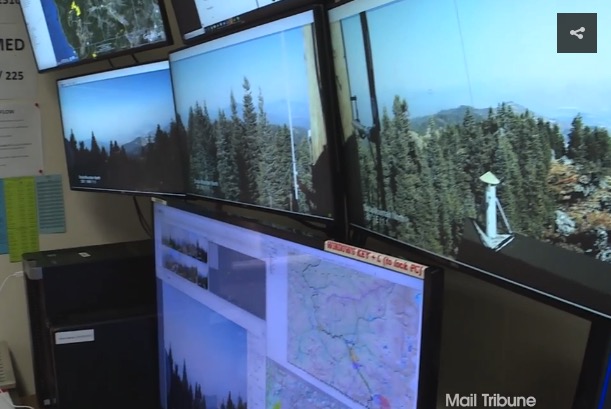
camera detect wildfire Oregon
Cameras are used to detect wildland fires in a detection center in Oregon.

(Originally published at 9:51 p.m. PDT October 13, 2018)

Wildland firefighters in Oregon and other locations are increasingly using technology to streamline dispatching, map fires, communicate, detect fires, and enhance situational awareness. An article at the Mail Tribune covers advances in fire detection, drones, mapping, and satellite imagery. Below are two excerpts.

…It’s called the detection center, and ODF employees who man its viewing stations are constantly on the lookout for just-sparked wildfires.

“Typically, what we’re looking for are slight movements,” [Chris] James says while gesturing at a bank of monitors that displays multiple views of the region’s hazy, forested landscape.

Each monitor contains four pictures that rotate through on the screens and are spaced over time, giving ODF workers the ability to see fires.

“We’re looking at those pictures for any sign that we don’t recognize, that we haven’t seen before, and that keys us up on smoke,” says James, a detection center supervisor.

The Bureau of Land Management utilized drone technology for a variety of purposes, including infrared heat detection, mapping, and scouting certain areas of terrain for possible fire lines. Unrelated to surveillance — but no less interesting — the agency utilized some of the unmanned aircraft to haul in supplies. The drones also were used for burnout purposes, dropping ping pong balls … which triggered a chemical reaction that ignited the plastic spheres.

We checked with Gil Dustin who leads the Bureau of Land Management Unmanned Aircraft Systems program. He said the federal land management agencies have not used drones to haul supplies. The aircraft they have been flying can only carry a few pounds at most. One day they may be resupplying firefighters with drinking water, food, fire hose, pumps, and chain saw fuel, but we are not there yet.

Mr. Dustin said years down the road helibases are going to look very different compared to what we are seeing today.

Thanks and a tip of the hat go out to Kelly.
Typos or errors, report them HERE.
Dozer rollover with injury, Sugar Pine Fire in Oregon

Rapid Lesson Sharing report

Dozer rollover
The dozer after rolling end over end down a steep 175-foot slope.

The description of a dozer rollover in a Rapid Lesson Sharing report indicates that the operator is lucky to be alive after the dozer tumbled end over end for 175 feet down a steep slope. In spite of the serious injuries, several things contributed to getting the patient to a hospital in one hour and 40 minutes in the middle of the night, including having a paramedic and a stokes litter nearby.

The accident occurred on the Sugar Pine Fire 11 air miles northwest of Prospect, Oregon.

There have been too many incidents involving dozers this summer. They are tagged “dozer” here on Wildfire today.

Below is the narrative from the RLS report. The full document with successes and lessons can be downloaded HERE.


On July 30, 2018 at 1:04 a.m., approximately one mile northwest of DP 25, a dozer slipped off the edge of a logging road and tumbled down end-over-end, 175 feet to the bottom of a ravine.

A Paramedic, fireline overhead, and a hand crew quickly responded to the accident site.

Within approximately five minutes, the Paramedic and a crew member were on scene conducting patient evaluation and providing medical treatment. The patient had a broken hip, ribs, and head lacerations.

The fire overhead directed crew members to cut a switchback trail to the bottom of the hill where the Paramedic was treating the patient. The patient was assessed/stabilized/packaged and transported in a Stokes basket to the top of the hill. Crews then loaded him into a vehicle for transport to a waiting ambulance.

The Deputy IC, Unit Medical Leader located in the communications tent had directed the ambulance to meet the truck with the patient on a nearby paved road. When the truck arrived, the patient was quickly transferred to the back of the ambulance then transported to the Medford Medical Center.

After the patient was evaluated, he was transported via Life Flight and admitted to Legacy Emanuel Hospital in Portland, Oregon.

(end of excerpt from report)


dozer rollover
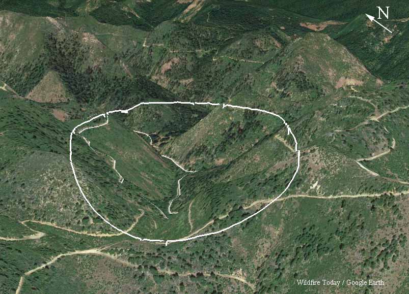
3-D map of the general area where the dozer rolled down the slope.