Has society chosen to have fire under the most extreme conditions?

Lolo Peak Fire
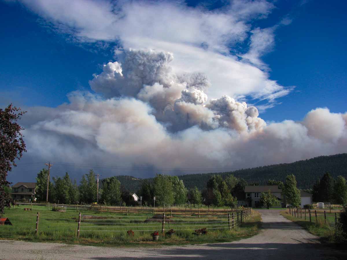
Lolo Peak Fire at 6:25 p.m. MDT August 19, 2017 as seen from the Missoula area. Photo by Dick Mangan.

An article by Rob Chaney in the Missoulian quotes a research forester and a Type 1 Incident Commander talking about the characteristics of the wildfires we have been experiencing in recent years. Below is an excerpt:


…“This has been a choice society has made to have fire under the most extreme conditions,” Mark Finney, a research forester for the U.S. Forest Service Fire Sciences Lab, told the Missoula City Club on Monday. “There are alternatives if we choose to use them, instead of waiting for fires to start and then responding to them.”

Greg Poncin, incident commander for both the Lolo Peak and Rice Ridge fires of 2017, added that 12 of the 30 largest fires in the past decade all occurred last year…

Rain slows wildfires in Northern Rockies and South Dakota

Above: Precipitation received at RAWS weather stations in northwest Montana in the 24 hours before 9:42 a.m. September 15, 2017. The amounts range from a few hundredths to almost half an inch.

Western Montana and the northern Great Plains are receiving some much needed moisture that will slow the spread of dozens of large fires in the area, some of which have been burning for more than a month and a half.

The Rice Ridge Fire has spread over 155,000 acres just east of Seeley Lake 35 miles northeast of Missoula, Montana since it was discovered July 24. The incident management team reported Thursday evening that the east side of the fire had received a quarter of an inch of rain. A weather station just northeast of the community of Seeley Lake recorded 0.05″ overnight, and the forecast calls for another quarter of an inch at that location on Friday.

A weather station near the 53,000-acre Lolo Peak Fire south of Missoula recorded 0.16″.

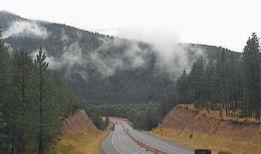
weather cam nine mile
A weather cam view at Nine Mile on Interstate 90 west of Missoula, 8:30 a.m. September 15, 2017.

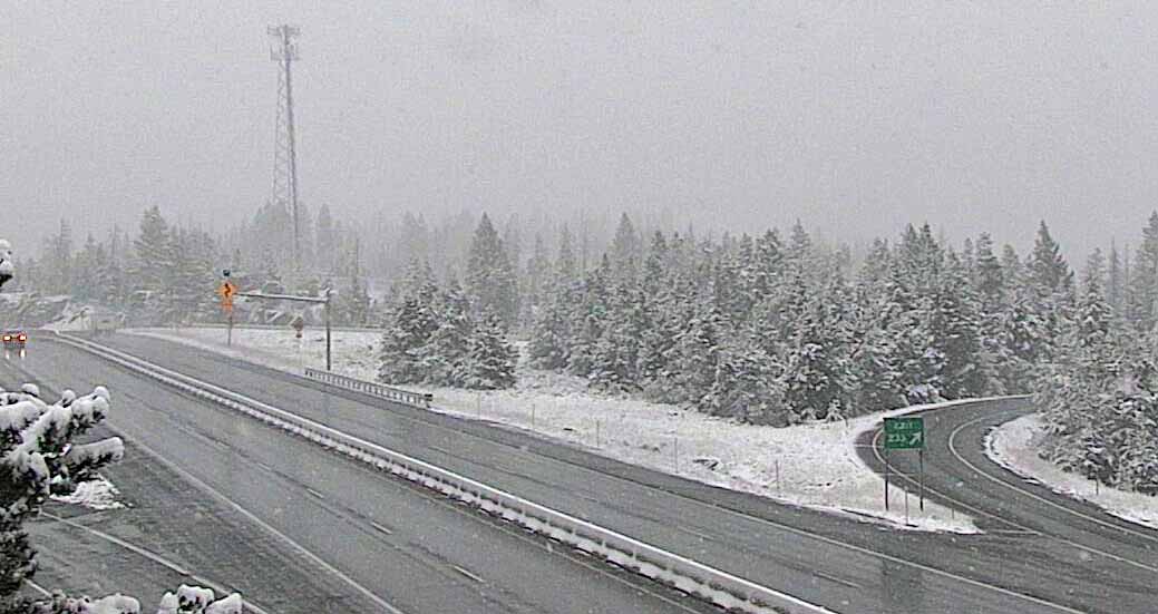
Some of the higher elevations in western Montana are receiving snow.

weather cam homestake pass
A weather cam view at Homestake Pass, 6,329′ elevation, on Interstate 90 southeast of Butte, MT, 9:08 a.m. September 15, 2017.

Firefighters are “backhauling” equipment on the Rice Ridge Fire, collecting items that are no longer needed and taking them back to the incident base, such as fire hose, water pumps, and portable tanks.

Most of the weather stations in the southern Black Hills where the Beaver and Rankin Fires are burning have received about a third of an inch of rain as of 10 a.m. on Friday, but one station northeast of Newcastle, WY measured almost three-quarters of an inch. Some firefighting resources, including crews and engines, were released from these two fires late in the day Thursday.

Rice Ridge Fire merges with Reef Fire

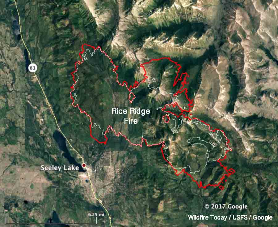
The Rice Ridge fire has burned 108,126 acres just east of Seeley Lake 35 miles northeast of Missoula, Montana.

Above: The red line on the map shows the perimeters of the Rice Ridge and Reef Fires at 12:45 a.m. September 5, 2017. The white line was the perimeter of the Rice Ridge Fire about 24 hours before.

(Originally published at 9:18 a.m. MDT September 5, 2017)

On Monday the Rice Ridge Fire grew on the south, east, and north sides adding another 6,701 acres, and has now burned 108,126 acres. It merged at Otis Creek with another fire to the north, the 10,424-acre Reef Fire. Combined, the fires have blackened 118,550 acres, well beyond the 100,000 threshold of becoming a “megafire”.

The spread on Monday was much less than on Sunday when it almost doubled. Numerous spot fires out ahead of the main fire from Sunday’s growth are active on the east side. On the south it spread for about a mile and crossed Cottonwood Lake-Monture Road.

The transition from Thompson’s Type 2 Incident Management Team to Poncin’s Type 1 Incident Management Team occurred at 6 a.m., Tuesday, September 5.

The weather forecast calls for moderate winds with rising temperatures through Friday, but the relative humidity will reach down into the teens each day.

There is not much expectation of rain on the fire this week except for a 20 to 30 percent chance Thursday night and Friday.

Resources assigned include 15 hand crews, 64 engines, and 4 helicopters. The total number of personnel on the fire decreased Monday from 817 to 787.
Rice Ridge Fire almost doubles in size to over 100,000 acres

At 10:45 p.m. Sunday it was mapped at 101,425 acres.

Above: The Rice Ridge Fire. Image uploaded to InciWeb September 3, 2017. Uncredited.

(Originally published at 10:11 a.m. MDT September 4, 2017)

The Rice Ridge Fire just east of Seeley Lake, Montana, spread substantially Sunday, almost doubling in size. During a 10:45 mapping flight Sunday night, it was discovered that 48,531 acres had burned during the previous 24 hours bringing the total to 101,419 acres, achieving “megafire” status when it exceeded 100K acres. The blaze is 36 miles northeast of Missoula.

The west side of the fire near Seeley Lake did not change — the growth was on the north and east sides.

The key factors in the extreme fire behavior and spread on Sunday were the relative humidity and the wind. During the morning the wind was out of the south, which accounted for the growth on the north side. Then it slowly changed to be from the southwest and the west and by 9 p.m. was coming from the north.

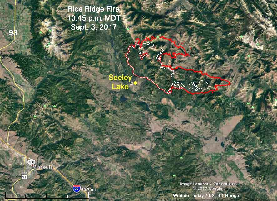
Rice Ridge Fire map
The red line was the perimeter of the Rice Ridge Fire at 10:45 p.m. MDT September 3, 2017. The white line was the perimeter about 24 hours before. Click to enlarge.

The relative humidity just north of the community of Seeley Lake reached 8 percent Sunday, while the temperature maxed out at 88 degrees with 6 to 12 mph winds gusting at 14 to 18. The forecast for Monday calls for more moderate conditions — 78 degrees, east winds at 10-13, and 21 percent relative humidity.

Rice Ridge Fire Montana fire map missoula
The map shows heat detected on wildfires in the Missoula area at 10:45 p.m. MDT September 3, 2017. Click to enlarge.

The objective on the fire is not to put it out or contain it, but to herd it around as necessary to protect private property and structures. On Sunday 737 personnel were assigned to the fire which so far has run up costs of almost $30 million.

Rice Ridge Fire forces evacuations at Seeley Lake, Montana

Above: A 3-D map of the Rice Ridge Fire, looking northeast. The red line was the perimeter at 10:30 p.m. MDT August 28, 2017. The white line was the perimeter two days earlier

(Originally published at 9:37 a.m. MDT August 29, 2017)

The Rice Ridge Fire made an unexpected southerly surge Monday evening toward the community of Seeley Lake after the wind direction shifted from the south and southwest to come out of the north and northwest. At about 7 p.m. Monday fire officials issued a mandatory evacuation order and three hours later expanded the area to include much of the community.

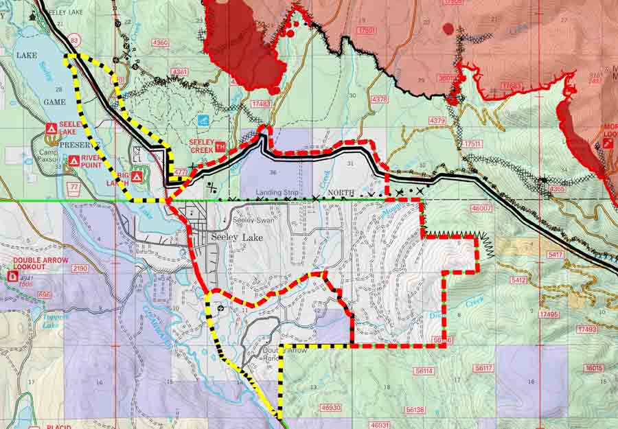
evacuation map rice ridge fire
Screen grab from a portion of the incident management team map of the Rice Ridge Fire dated August 29, 2017. The red dashed line is labeled “evacuation” while the yellow dashed line is “warning”. The solid red area was the fire at 10:30 p.m. MDT August 28. For the most current evacuation information go to Inciweb.

When the fire was mapped by a fixed wing aircraft at 10:30 p.m. Monday the Rice Ridge Fire had approached to within 1.5 miles of the Seeley Lake Community after a large finger of fire spread from the western flank. Sunday evening the incident management team had written in their evening update:

Containment is up to 22% as crews completed fire line along the west flank of the fire. Firefighters successfully completed small firing operations along the west and southwest edge of the fire that will aid in securing fire line.

The term “contain” or containment percentage means a fire line has been established along a portion of the perimeter. It does not mean the fire is “controlled” or “out”.  A 2-foot wide or 100-foot wide fireline is not guaranteed to stop the fire at that point. Strong winds have been known to blow burning embers and start new spot fires more than a mile away. The incident management team appears to be computing the containment percentage the way it should be done — showing the percentage of the fire perimeter where a fireline is completed and the spread is at least temporarily halted. The fire could continue to spread across the fireline, but it is not thought likely. The unexpected wind shift may have been the unlikely occurrence in this case.  The definition of these and hundreds of other fire management terms are in the National Wildfire Coordinating Group Glossary.

map rice ridge fire
Map of the Rice Ridge Fire. The red line was the perimeter at 10:30 p.m. MDT August 28, 2017. The white line was the perimeter two days earlier

An incursion into the air space over the fire by a drone shut down all firefighting aircraft Sunday evening.

Seeley Lake is closed so that firefighting aircraft can safely access the lake to refill their water buckets or tanks.

The incident management team is not releasing a great deal of information about the fire. It has been almost two weeks since photos were posted on their Inciweb page.

Update on Chetco Bar Fire and other wildfires in the Northwest

Above: Satellite photo from August 27, 2017 showing smoke created by fires in the Northwestern United States, including Chetco Bar, Liberty, Rice Ridge, and Jolly Mountain Fires. The red dots on the map represent heat detected by the satellite on August 28.

(Originally published at 9:55 a.m. MDT August 28, 2017)

The Chetco Bar Fire in Southwest Oregon has not been growing as quickly in recent days as it did earlier when it quadrupled in size over four days and crossed the 100,000-acre threshold. The most recent mapping puts it at almost 108,000 acres. The area is under a Red Flag Warning on through Tuesday for gusty southwest winds and low humidities which could result in increased burning intensity and rapid fire growth.

The 4,400-acre Jolly Mountain Fire in Central Washington is near a Red Flag Warning area. Fire officials’ expectations for Monday:

Southern and western flanks of the fire will become active with uphill crown runs both on the east and west sides of West Fork drainage. SE flank will continue to back downslope. Fire will become increasingly active as it spreads to the south, where it loses its downslope effect and in more exposed to general winds. Fire likely to cross Sasse Ridge to the west.

liberty fire dozer
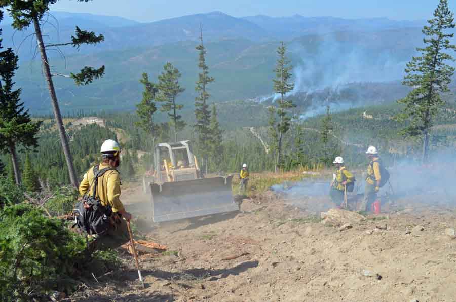
A dozer passes through an area where firefighters are working on the Liberty Fire. Undated & uncredited Inciweb photo.

The 12,800-acre Liberty Fire has been burning northeast of Missoula, Montana since July 15 while the Rice Ridge Fire, not far away, has spread over 27,800 acres since it started two weeks later. Hot, dry weather on Monday could cause both blazes to become more active.