Wildfire morning briefing, October 20, 2012

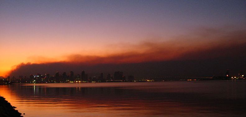
Smoke from the Witch Creek fire
Smoke from the Witch Creek fire as seen from San Diego harbor, October 23, 2007. Photo by Kat Miner

Witch Creek fire, five years later

Five years after the Witch Creek fire burned 197,990 acres and 1,040 homes in San Diego County, most of the structures have been rebuilt and lessons have been learned about how to better manage similar incidents, before, during and after they occur.

Followup on fire in Bucyrus, North Dakota

An analysis after the fire has determined that four residences and 20 outbuildings were destroyed when a wildfire raged through the small town of Bucyrus, North Dakota October 17. It blackened 6,000 acres along a 10-mile long path. NBC News has some photos that were taken after the fire.

Fire in Nebraska jumps Interstate 80

A 10,000-acre fire destroyed three residences and jumped over Interstate 80 near Paxton, Nebraska on Friday.

Photos of effects of winds in South Dakota

The very strong winds that affected wildfires in South Dakota this week also left some other impacts. The Rapid City Journal has some excellent photos, including one that shows four tractor-trailer trucks that got blown over along a 1/4-mile stretch of Interstate 90.

John N. Maclean’s OP-ED

John N. Maclean had an opinion piece published on the New York Time’s web site October 18 in which he wrote about penalties that have been assessed against arsonists and others who have started wildfires. He also provided some thoughts about how to prevent fires through legislation, and wrote about fires started by shooters, exploding targets, and all-terrain vehicles. Mr. Maclean is the author of several books about wildland fires, including Fire on the Mountain, The Thirtymile Fire, and the forthcoming book The Esperanza Fire: Arson, Murder and the Agony of Engine 57, about a 2006 wildfire in California.

Waldo Fire volunteer faces sex assault charge

A man who was volunteering for the Red Cross during the Waldo Canyon fire in Colorado Springs earlier this year is facing charges of sexually assaulting another volunteer. The victim told police she believes 71-year old Allen Crabtree drugged her and then sexually assaulted her on July 7.

Thanks go out to Kelly and Dietra

Photos of the Fork and Glenerin Fires


Fork FireWe checked out the Fork Fire west of Custer, SD, and the Glenerin fire east of Custer this afternoon and shot some photos. The Fork Fire was pretty quiet and had a fire line around it. There was still some interior burning going on and quite a bit of mop-up left to do, but thanks to the good work of the firefighters the prognosis is good.

These first photos are of the Fork Fire. The Glenerin photos are farther down.

(More information about these fires.)

Fork Fire
There were a handful of structures within and adjacent to the fire that were protected and saved.
Fork Fire
Much of the area that burned had been thinned. There was virtually no torching or crowning anywhere in the fire due to the thinning, the wide spacing of the trees, the lack of ladder fuels, the low Haines Index, and the very strong wind that did not allow heat to build up in the crowns, keeping the fire on the ground.

More photos are below.

Continue reading “Photos of the Fork and Glenerin Fires”

58,000 acres burned in Nebraska Wednesday

Map showing location of fire near Crookston, NE
Map showing location of a fire near Crookston, NE. The white line going east-west across the map is the South Dakota/Nebraska border.

The strong winds created by a cold front challenged firefighters in Nebraska on Wednesday. At least 58,000 acres burned in numerous fires across the state, according to Jodie Fawl, Public Information Officer for the Nebraska Emergency Management Agency. The fires in Boone, Cherry, Fillmore, Holt, Knox, Merrick and Nance counties brought the total fire acreage across the state to about 300,000 acres for this fire season.

The largest fire was in Cherry County. It started in South Dakota and burned a path approximately 15 miles long and five-miles wide. The fire burned 3,000 acres in South Dakota before entering Nebraska north of Kilgore. The number of acres burned in Nebraska is undetermined. On Wednesday 25 mutual aid fire departments fought the fire near Crookston, Nebraska which was evacuated Wednesday.

Other fires in Nebraska, listed by county, with information current as of 1 p.m. CT, October 18, 2012:

Holt -The Stuart fire is mostly contained, and crews are on-scene working hot spots. An estimated 600 acres burned including several outbuilding. A mile of trees west of Stuart was still on fire, and not contained.

Knox – A fire south of Center started this morning but is now fairly well contained thanks to the 11 responding fire departments. Approximately 200 to 300 acres were affected.

Boone, Merrick, Nance – Cedar Rapids fire remains at 100 percent contained on 500 acres. St. Edward is 100 percent contained on an estimated 160 acres. Genoa is contained in a canyon but is still active with dry timber surrounding the rim of the canyon. The fire is 50 percent out with 80 acres affected. The hay bales near Palmer are 95 to 100 percent out and did not spread beyond the feed lot.

Filmore– Approximately 75 percent contained. Nine fire departments are on scene.

Numerous fires in the Black Hills

Map, Fork and Glenerin fires,
Map showing heat detected by a satellite on the Fork and Glenerin fires, 2:15 p.m. MT, October 18, 2012. Click to enlarge.

(UPDATED at 9:06 a.m. MT, October 19, 2012.)

The very strong winds that accompanied a cold front moving across the northern great plains on Wednesday and Thursday fanned at least 15 fires into life over the last 36 hours in the Black Hills of South Dakota. Most of them were successfully suppressed by very busy firefighters working without the benefit of aircraft which were grounded by the winds.

Two fires, both of them near Custer are still active as this is written at 7:10 a.m. on Friday.

Fork Fire

The Fork fire is 5 miles west of Custer and about 1.5 miles north of Highway 16 near the intersection of Renegade Pass and North Pole roads. The fire has burned 353 acres on both private and Black Hills National Forest lands and is reported to be 50 percent contained. A Type 3 Incident Management Team led by Incident Commander Matt Spring is suppressing the fire. It is human-caused but is under investigation.

Fork Fire
Fork Fire, October 18, 2012. InciWeb photo (click to enlarge)

Evacuations that were in place for 15 residences in the Renegade subdivison near Renegade Pass Road have been lifted. The North Pole road that was closed has reopened. One outbuilding burned in the fire.

A weather station 11 miles south of the fire recorded at 1:55 p.m. on Thursday sustained winds of  26 mph gusting to 48 mph which contributed greatly to the rapid spread of the fire. The weather forecast for Friday will be encouraging to firefighters. The winds will be much more sedate — northwest at 4 to 7  mph becoming west 6 to 10 in the afternoon. The temperature will be 58, the relative humidity will bottom out at 23 percent, and the cloud cover will be 25  increasing to 40 percent.

Glenerin Fire

The Glenerin fire is approximately 3 miles east of Custer, south of Highway 16 and Stockade Lake. The estimated size on Thursday was 10 to 30 acres and it was 5 percent contained. About 20 residents were notified to be ready to evacuate if the fire continued to spread.

The fire is burning on both private and National Forest lands. The cause is under investigation.

Strong winds in South Dakota through Thursday

Weather forecast, Wind Cave NP October 16-18, 2012

The weather forecast above is from the National Weather Service and is for Wind Cave National Park in southwest South Dakota. (Click on the image to see a larger version.)

Very strong winds and enhanced fire danger will prevail over South Dakota through Thursday. Thanks to a cold front moving through the area, sustained wind speeds in some area should be in the 20s, 30s, or 40s with gusts in some areas at 40 to 60 mph.

Below is an excerpt from a message distributed today by Darren R. Clabo, South Dakota State Fire Meteorologist.

=============================================================

A strong upper level trough will force a potent cold front to push across the state this evening. A few showers are possible along this frontal boundary and some of the weather models are even showing a wetting rain over western SD and the Black Hills.

Some lightning may accompany these showers so we’ll have to watch for any new ignitions.

Temperatures will quickly drop with this front but the real change will be seen in the winds: southwest winds will switch to the northwest and dramatically increase in speed. Gusts to 40 mph are possible overnight behind the front as it crosses the state.

Post-frontal conditions can then be expected tomorrow. Highs will only reach the mid to upper 50s across the prairies with mid 40s expected over the Black Hills. A very strong pressure gradient will persist throughout the day. This will allow the northwest winds to reach sustained speeds 35-45 mph with gusts exceeding 60 mph. A High Wind Watch is in place for this event. In addition, the post-frontal airmass will be quite dry and minimum RHs will range from 15% over southwestern SD to 25% over northeastern SD.

Critical fire conditions will ensue. Expect Extreme Fire Danger over all of the SD plains with Red Flag Warnings likely over East River. Explosive fire growth is possible any in the state tomorrow with the wind and exceptionally dry fuels. The strong northwest winds will continue throughout Wednesday night.

Thursday will not bring much relief as the northwest winds will like again be in the 30-40 mph range with gusts exceeding 50 mph. There may be some precipitation across northeast SD but the rest of the state will see dry conditions with enhanced fire danger once again. Highs will be in the 50s.

Red flag warnings and record-breaking heat expected in California

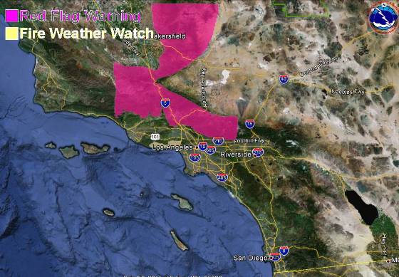
A weather forecast for record-breaking triple-digit heat and single digit humidities has brought out a red flag warning for some areas in southern California for Monday and Tuesday. The temperatures are expected to be about 20 degrees hotter than normal,  between 95 and 105 at the lower elevations in the mountains of Los Angeles and Ventura Counties on Monday, then a few degrees cooler on Tuesday. Downtown Los Angeles is expected to hit 100 degrees on Monday, with it reaching 105 degrees in Burbank and Pasadena.

Northeast winds at 10 to 20 mph with 30 mph gusts are expected on Monday, with Tuesday afternoon bringing 25 mph onshore winds.

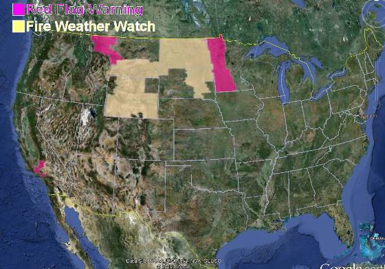
Red Flag Warnings, October 1, 2012

The map below shows the area in southern California covered by the red flag warning, which is in effect from 6 a.m. Monday until 6 p.m. PDT Tuesday.

Red Flag Warning, Southern California, October 1, 2012

There is also a red flag warning for some areas in northwest Montana for gusty winds and low humidities from 11 a.m. through midnight MDT on Monday. The winds are expected to be southwest at 15 to 25 mph with gusts up to 50, with the humidities as low as 16 percent.

The passage of a cold front has resulted in a red flag warning for western Minnesota from 2 p.m. until 7 p.m. CDT on Monday. Winds should be northwest at 20 with gusts up to 30 mph along with humidities as low as 20 percent.

A fire weather watch is in effect for areas in Wyoming, Montana, North Dakota, and South Dakota.