Hunga Tonga volcano triggered nearly 400,000 lightning strikes

C-130 aircraft to parachute drop drinking water and other emergency supplies for Tonga residents

Lightning Hunga Tonga volcano
Lightning at the Hunga Tonga volcano. Still image from video by Potungaue Koloa Fakaenatula / Servicio Geológico de #Tonga.

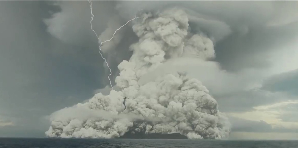
The massive underwater Hunga Tonga volcano that erupted near Tonga in the South Pacific on January 14 triggered almost 7 hours of lightning as well as a tsunami. A ground-based lightning detection system recorded nearly 400,000 strikes with 200,000 occurring in a one-hour period. For comparison, a severe lightning bust in northern California might have hundreds or a few thousand strikes. The ash cloud reached at least 60,000 feet with some reports saying the initial plume reached 100,000 feet, three times the altitude of commercial airliners.

Below is a video showing part of the eruption recorded by Potungaue Koloa Fakaenatula / Servicio Geológico de #Tonga. A lightning strike or two can be seen at 29 seconds. Most of the lightning was probably inside the ash plume or higher in the column.

The nearby island of Tonga was heavily affected by a four-foot tsunami followed by deposits of ash, which at least temporarily contaminated water supplies and shut off most utilities. A C-130 from New Zealand was scheduled to drop supplies by parachute.

The volcano is part of the highly active Tonga–Kermadec Islands volcanic arc, a subduction zone extending from New Zealand north-northeast to Fiji.

Vegetation buried by lava produces methane burning with blue flame

Above: Blue flames can be visible when vegetation buried by hot lava produces methane which vents and is then ignited. Screenshot from USGS video.

What’s happening on Hawaii’s big island as the eruption of the Kilauea volcano enters its fourth week seems like it is from another world — huge mounds of red-hot lava rumbling in slow motion over homes and forests as it makes it to the sea. Where it enters the cold water it produces what is called “laze,” hydrochloric acid steam that pours into the air along with fine particles of glass. Laze can cause lung, eye, and skin irritation and caused the deaths of two people in 2000.

Since it is the wet season in Hawaii brush fires caused by the eruption are not a big concern, but the lava finds a way to burn the vegetation regardless. The USGS explains:

When hot lava buries plants and shrubs, methane gas is produced as a byproduct of burning vegetation. Methane gas can seep into subsurface voids and explode when heated, or as shown in this video, emerge from cracks in the ground several feet away from the lava. When ignited, the methane produces a blue flame. Intermittent short bursts of methane are visible in the center area of the video. Lava fountaining is visible to the right and left sides of the video.

Lava causes brush fire in Hawaii

The eruption and lava flow from the volcano on Hawaii’s big island has ignited vegetation, causing a fire and forcing additional evacuations.

Below is an update from Hawaii County Civil Defense issued Saturday evening:

This is a Civil Defense Message for Saturday, May 19 at 9:00 in the evening.

Hawaiian Volcano Observatory continues to monitor active flows.  The flow originating from fissure 20 has again split into two lobes, both are currently heading in the general direction of the 13 mile marker on Highway 137.  Flow front #1 is approximately 630 meters from Highway 137 and moving about a 100 meters per hour.  Flow front #2 is approximately 750 meters from Highway 137 and moving about the same speed.  At the current rate, the lava flow may cross the highway within the next five to seven hours.

Highway 137 is closed between Kamaili Road and Pohoiki Road.  Kamaili Road is closed between Highway 130 and Highway 137 due to a brush fire. Residents in the area have been evacuated.

lava volcano brush fire
Photo from Twitter user Kimberly @kimberlyaliceMT:
Just for a little bit of scale and a reality check… The two circled white specks are @USGSVolcanoes workers going down to collect lava samples earlier today.


A prescribed fire, burning operation on a wildfire, or volcano?

At first glance it looks like it could be any of the three

The USGS released this photo today in their update on the Hawaii volcano:

#HVO #Kilauea May 16 evening update: Ash emission at the summit has decreased and is drifting slowly northward. M3+ EQs at the summit caused Hwy 11 cracking. Decreased spattering at fissure 17. goo.gl/hCVW5T

“M3+ EQs” means magnitude 3+ earthquakes.

Two teams are managing the volcano incident in Hawaii

Two separate organizations are managing the issues surrounding the eruption of the Kilauea volcano in Hawaii.

The fissures we have been hearing about that are producing toxic gasses and lava flows are on private land on the big island, the Island of Hawaii.

Kilauea volcano fissures map
Map showing the location of the volcano fissures on the Big Island. Click to enlarge.

The large, black convection column is at the Kilauea volcano in Volcanoes National Park 23 miles west of the fissures.  After the level of the lava lake fell by several hundred feet, freshly exposed rocks on the sides of the crater began falling into the lava, creating the black smoke and ash clouds sometimes rising several thousand feet. Due to this and the possibility of a massive explosion if water is introduced into the volcano, creating steam, at the request of the NPS the FAA has issued a Temporary Flight Restriction that extends 20,000 feet AGL and a 12-nautical-mile radius around the summit.

In response to our inquires, Volcanoes National Park Fire Management Officer Greg Funderburk sent us this description of how the incidents are being managed:


“There are currently two separate incidents being managed on the Island of Hawaii.  These incidents are both associated with the Kilauea Volcano.

“The Leilani Fissure Eruption is being managed by Hawaii County and the Hawaii County Civil Defense Agency.  FEMA and the Hawaii Emergency Management Agency are assisting with the overall management effort.  This incident is located on private land in the rural Puna district of Hawaii County.

“There is currently no significant wildfire activity associated with the lava flow.  The area has been receiving frequent rainfall and fuels are in the greenup stage.  If the lava activity continues into the dry season wildfire potential may increase.

“On-scene Incident Management of the Leilani Fissure Eruption is currently being provided by a Type 3 Incident Management Team (IMT) from the Honolulu Fire Department (IC-Bowers) under a Delegation of Authority from the Hawaii County Fire Department.

“The National Park Service is managing an event within the boundaries of Hawaii Volcanoes National Park.  The 2018 HAVO Increased Volcanic Activity Incident has been managed by a local Type 3 organization (IC-Broward), but transfer of command will take place to the NPS Western IMT (IC-Wissinger) at 0800 on May 16, 2018.  The IMT is managing the risk associated with a possible large steam eruption that is predicted to occur at the summit of Kilauea.”


Mr. Funderburk explained that some of the objectives of the IMT include maintaining closures, damage assessments, disseminating information, and managing traffic.

Links to more information:

Images from the volcano eruption in Hawaii

The eruption of the volcano on the Big Island in Hawaii is certainly tragic for the owners of the 26 homes that have been destroyed and the 1,700 residents of Leilani Estates that have been forced to evacuate. We are not going to try to cover the incident like we would a large vegetation fire — primarily because it is very difficult to obtain the kind of information we would normally collect about a fire. We have made some inquiries with a couple of agencies but distributing information to the media could be pretty far down their list of priorities. They no doubt have their hands full.

But we have found a bit of information about what is going on there. Approximately 104 acres are directly affected by vents, fissures, or 2,000F-degree lava. The activity paused for a bit Monday, but Tuesday morning two additional fissures developed, bringing the total to 14 and requiring the total evacuation of  Lanipuna.

Previous eruptions on the island have ignited vegetation fires, but while we have seen some trees and shrubs burning in videos, it seems to mostly be when they are directly contacted by the molten lava.

A friend of ours has been in Hawaii for at least a week and most of the numerous photos he has posted on Facebook have shown cloudy skies. The weather Monday and Tuesday at Hilo included rain with humidities in the 90’s, so until that changes there might not be much of a wildfire threat.

If any of our readers have confirmed information about resources assigned or an Incident Command System being used, let us know in the comments.

Here is a link to a live camera.

I don’t know what Hell looks like, but….. the video below of the lava in the crater is incredible.

volcano photo
On May 5 lava from fissure 7 slowly advanced to the northeast on Hookapu Street. USGS photo.

Overflight in Leilani Estates: fissure 12 opens shortly after fissure 11 becomes inactive. Fissure 12 in the forest south of Malama Street. https://t.co/w5XLplnwVHpic.twitter.com/IdUmtORibY

volcano May 6 map

volcano photo may 5
In the Leilani Estates Subdivision, fissure 7 was active for several hours on May 5 with large bubble bursts and spatter. A short lava flow moved northeast and crossed Hookupu St. USGS photo.