Firefighters concerned about possible sundowner winds on Whittier Fire

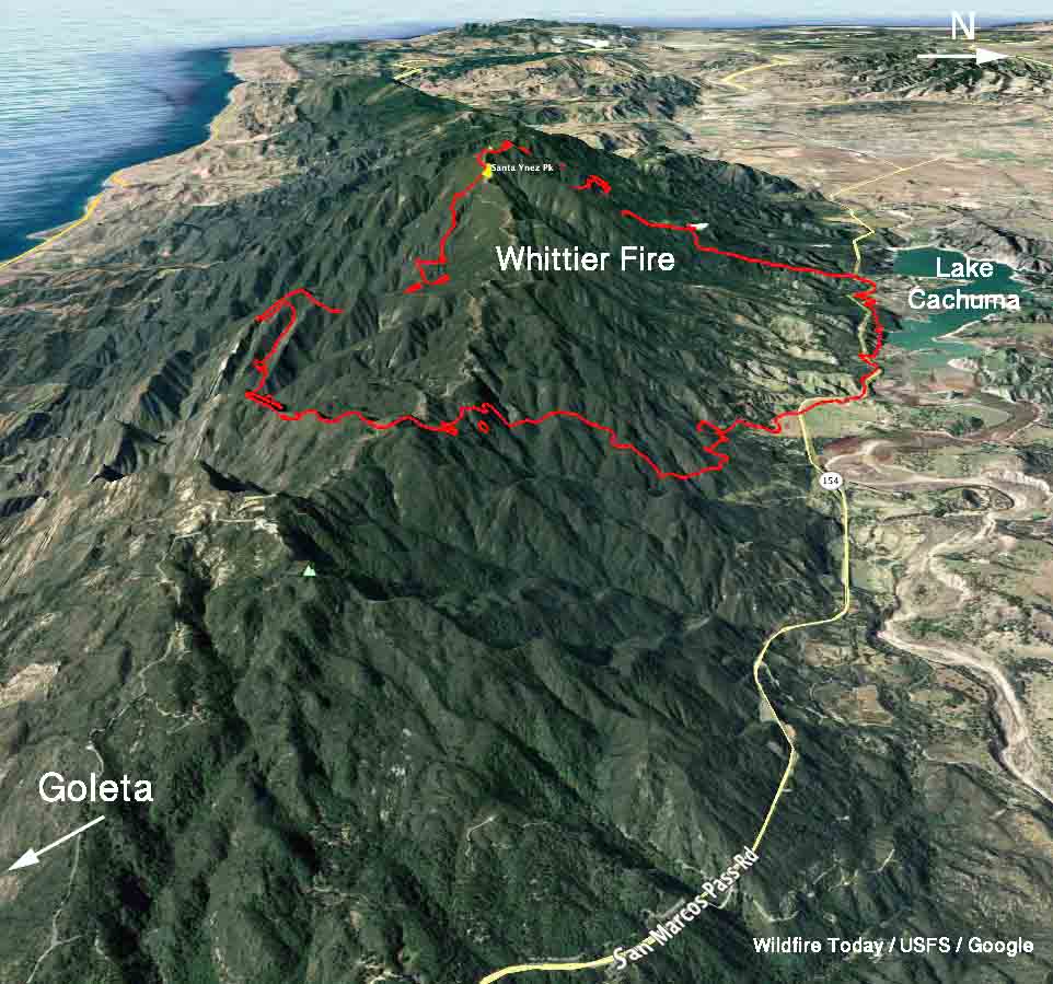
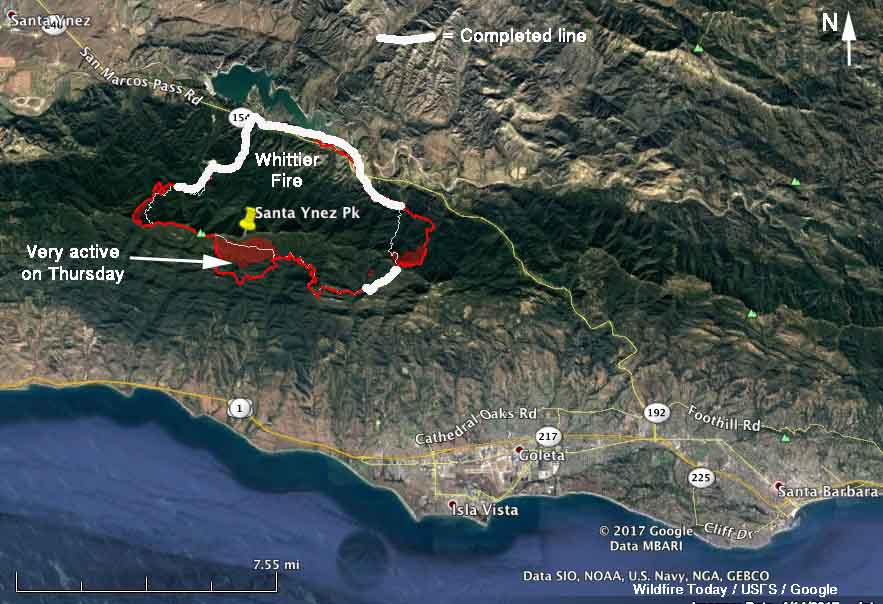
Above: 3-D map of the Whittier Fire current as of 10 p.m. PDT July 13, 2017. The red shaded areas had more intense heat than other locations.

(UPDATED at 9:18 p.m. PDT July 14, 2017)

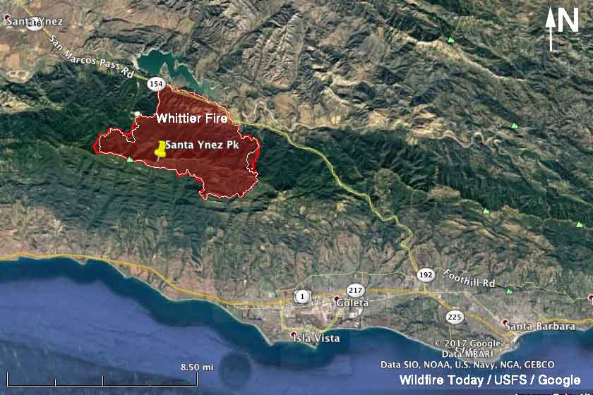
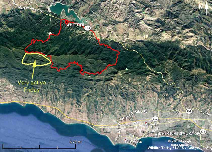
Here is a map showing some of the expansion of the Whittier Fire that was detected by a satellite at 1:24 p.m. PDT on Friday July 14. It is likely that the fire continued growing after that time.
Whittier Fire map
Whittier Fire map, showing the area in yellow that was growing at 1:24 p.m. PDT July 14, 2017. Click to enlarge.

The weather forecast for Friday night indicates that the fire on the upper section of the south-facing slope below Santa Ynez Peak above the marine layer could remain active at least until sunrise. In that area the relative humidity will be in the low 20’s with a wind out of the northeast at 12 to 15 mph gusting at 18 to 23. There could be gusts above 30 mph from 10 to 11 p.m. Friday night.

On Saturday the winds will decrease during the day on that upper slope but pick up again after 6 p.m. with north-northwest winds of 23 mph gusting to 35.

****

(UPDATED at 3:48 p.m. PDT July 14, 2017)

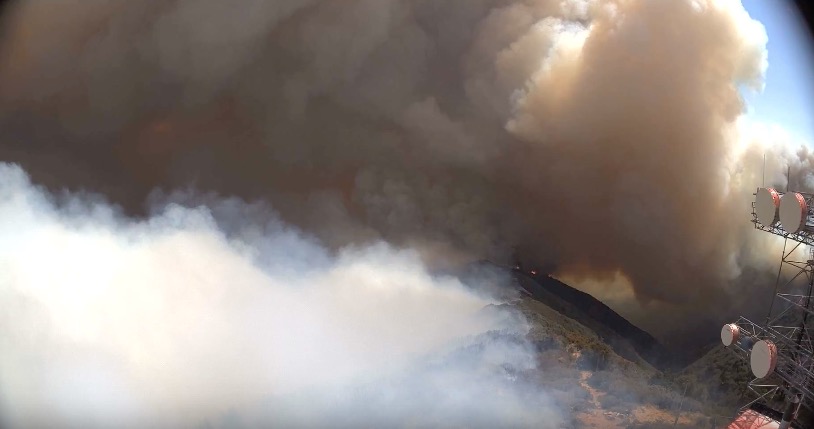
The Whittier Fire has been extremely active on Friday, putting up large columns of smoke. Evacuations are in effect in several areas.

If you put the video below on full screen you’ll see a DC-10 making a retardant drop low on the slopes northwest of Goleta, CA.

****

(Published at 10:20 a.m. PDT July 14, 2017)

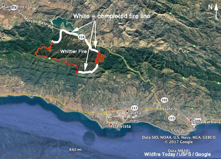
Firefighters on the Whittier Fire northwest of Goleta, California have made some limited progress in constructing fireline around the blaze over the last two days. Approximately half of that task is done, but the remaining sections are in steep, difficult terrain. A large flare-up south of Santa Ynez Peak that started after sundown Thursday and continued until about 1 a.m. had some residents of Goleta and Santa Barbara worried. It occurred on the upper slope above fuels that have been influenced by the marine layer.

A weather forecast that includes the possibility of sundowner winds Friday afternoon concerns firefighters since they could produce wind gusts of 25-30 mph through passes and gaps in the vicinity of the fire. The forecast for Friday for the upper slope below and south of Santa Ynez Peak, updated at 10 a.m. on Friday, is for 88 degrees, 31 percent relative humidity, and winds out of the west at 12 mph gusting to 18. After 6 p.m. the winds should become out of the northwest at 19 gusting to 29. The incident management team is bringing in additional firefighters for this wind event.
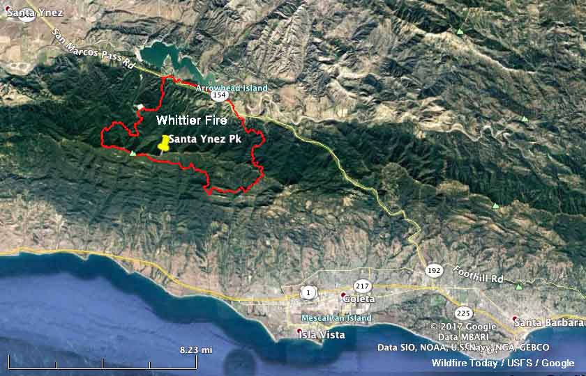
map whittier fire
Map of the Whittier Fire current as of 10 p.m. PDT July 13, 2017. The red shaded areas had more intense heat than other locations. Click to enlarge.

The fire was mapped Thursday night at 13,199 acres. Resources assigned include 1,240 personnel, 92 fire engines, 23 hand-crews, 16 dozers, 12 helicopters, and 23 water tenders.

The video below by KEYT was streamed live on YouTube, showing and explaining the activities at a facility set up at the Whittier Fire for mixing retardant for helicopters that could draft to refill their tanks; that is, through a hose on the helicopter they pumped retardant from a tank on the ground while hovering. The 11-minute video did not show any ships with buckets — just Type 1 helicopters with internal or external tanks.

****

All of the articles we have written about the fire are tagged “Whittier Fire” and can be found here, with the most recent at the top.

How firefighters rescued 80 children trapped during the Whittier Fire

Congratulations to the firefighters involved in this rescue.

Since it started on July 8, the Whittier Fire has burned over 13,000 acres northwest of Goleta, California.

****

UPDATED January 30, 2018:

A U.S. Forest Service employee is being  honored by attending the President’s State of the Union Address scheduled for 9 p.m. ET Tuesday.

Dave Dahlberg, a Fire Prevention Technician on the Los Padres National Forest working out of Pine Canyon Fire Station, helped rescue 62 children and staff members at the Circle V Ranch Camp during the Whittier Fire July 8, 2017.

This is a big deal. Congratulations to FPT Dahlberg!

Mr. Dahlberg will be one of 12 special guests of President Trump and will be seated with First Lady Melania Trump.

(The rest of the story.)

Firefighters making progress on Whittier Fire, but it was very active on west side Tuesday

Above: A 3-D map of the Whittier Fire looking southeast. The data was updated at 7:30 p.m. PDT July 11, 2017. The areas shaded in light red were burning very actively when the fire was mapped.

(Originally published at 7:52 a.m. PDT July 1, 2017) 

Firefighters have completed a containment line around almost half of the Whittier Fire northwest of Goleta, California, but it was still very active in some areas Tuesday. On the east side it spread into Hot Springs Canyon putting up a large plume of smoke that got the attention of residents in Goleta and Santa Barbara. But as of 7:30 p.m. on Tuesday the east side was still about half a mile away from San Marcos Pass Road which has served as a barrier on the north side.

By 7:30 p.m. Tuesday it had burned 11,920 acres.

map Whittier Fire
Map of the Whittier Fire updated at 7:30 p.m. PDT July 11, 2017. The areas shaded in red were burning very actively when the fire was mapped. Click to enlarge.

A containment line is complete on the northwest side from San Marcos Pass Road up to the rock quarry, but beyond that, going up the slope, the terrain is much more steep and complex. Firefighters are scouting that area up to the ridge, hoping to find a route for a line.

Wednesday morning a deeper marine layer put a damper on fire activity. Later in the day the forecast for the north side of the fire calls for mostly sunny skies, 88 degrees, 37 percent relative humidity, and winds at 8 mph gusting to 12 shifting from the southeast to the southwest and eventually out of the west.

All of the articles we have written about the fire are tagged “Whittier Fire” and can be found here, with the most recent at the top.

Whittier Fire showed moderate growth on Monday

Above: A 3-D map of the Whittier Fire, looking west. The perimeter at 2:30 a.m. PDT on July 11 is shown in red. The white line was the perimeter 28 hours before.

(Originally published at 7:38 a.m. PDT July 11, 2017)

The Whittier Fire six miles northwest of Goleta, California showed moderate growth on Monday. The most active areas were the south side and the upper slopes on the east and west sides. The Incident Management Team has not changed the reported size yet and is still calling it 10,823 acres.  The onshore breeze, higher humidity, and cooler temperatures worked in favor of the firefighters.

On Monday dozers worked the east flank from the Winchester Gun Club toward Hwy. 154. On the west side firefighters improved initial firelines and scouted for an area to complete the line up to Santa Ynez Ridge.

Whittier fire map
The perimeter of the Whittier Fire at 2:30 a.m. PDT on July 11 is shown in red. The white line was the perimeter 28 hours before.

Retardant lines are temporarily holding the south line while the incident management team works with local ranchers and residents to determine the best location for a fire line north of Goleta.

Most of the area within the perimeter of the fire has not burned since the Refugio Fire in 1955. Over the last several years these fuels have been stressed by the exceptional drought conditions and a high percentage of the fuel bed is dead. The combination of old, dry fuels with a newly cured heavy grass crop contributed to the rapid growth of this fire.

A total of 842 firefighters are assigned, including 97 fire engines, 11 hand crews, 8 dozers, 8 helicopters, and 2 water tenders.

The 20 structures that burned during the early stages of the fire included 8 residences and 12 outbuildings.

The weather forecast for the north side of the fire today predicts mostly sunny skies, 84 degrees, 40 percent relative humidity, and 7 mph southwest winds gusting to 12. Similar conditions are expected to continue through Thursday.

The photo below makes me wonder if binoculars were available during the briefing.

All of the articles we have written about the fire are tagged “Whittier Fire” and can be found here, with the most recent at the top.

Whittier Fire was very active Sunday, but was slowed overnight by high humidity

Above: Whittier Fire, looking west from Santa Ynez Peak at 5:53 a.m. PDT July 10, 2017.

(Originally published at 6:25 a.m. PDT July 10, 2017)

The Whittier Fire was very active all day Sunday and into the evening and as of 10:30 p.m. a mapping aircraft observed intense heat along most of the perimeter. The exception was the north side near Lake Cachuma and the lower slopes along San Marcos Pass Road.

Sunday night after midnight the relative humidity at Santa Ynez and Los Prietos climbed into the 60s and 70s and by dawn some of the cameras on Santa Ynez Peak captured what looked like either fog or smoked trapped in a valley inversion.

map Whittier Fire
Map of the Whittier Fire showing the perimeter acquired from an aircraft at 10:30 p.m. PDT July 9, 2017. Click to enlarge.

The Incident Management Team announced Monday morning the fire has burned 10,823 acres. Evacuations are still in effect and San Marcos Pass Road, Highway 154, is closed.

The weather forecast for the fire area on Monday is moderate by fire behavior standards. Temperatures on the north side of the fire near Lake Cachuma should be in the low 80s, the relative humidity in the low 40s, and a sea breeze will be southeast to southwest at 7 to 9 mph with gusts up to 14.

map Whittier Fire 3-D
3-D map of the Whittier Fire showing the perimeter acquired from an aircraft at 10:30 p.m. PDT July 9, 2017.
Whittier Fire
Looking north from Santa Ynez Peak at 5:53 a.m. PDT July 10, 2017.

All of the articles we have written about the fire are tagged “Whittier Fire” and can be found here, with the most recent at the top.
Whittier Fire as seen at Santa Ynez Peak

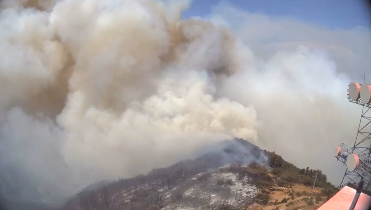
Cameras on Santa Ynez Peak nine miles northwest of Goleta recorded these images Sunday between 10 a.m. and 2:21 p.m. PDT. As you can see the fire burned up to the peak which has many electronic sites, various radio repeaters, transmission towers, and cell phone facilities. The fire caused the commercial electricity to be interrupted at the site, but the tower these cameras are on and probably others are being powered by emergency generators.

Whittier Fire Santa Ynez Peak Whittier Fire Santa Ynez Peak Whittier Fire Santa Ynez Peak

The cameras are operated by the High Performance Wireless Research and Education Network (HPWREN), a University of California San Diego partnership project led by the San Diego Supercomputer Center and the Scripps Institution of Oceanography’s Institute of Geophysics and Planetary Physics.

Whittier Fire Santa Ynez Peak
This camera was hit by fire retardant, which covered the lens.

All of the articles we have written about the fire are tagged “Whittier Fire” and can be found here, with the most recent at the top.