Texas battling numerous large fires

WEDNESDAY EVENING UPDATE FROM CNN:
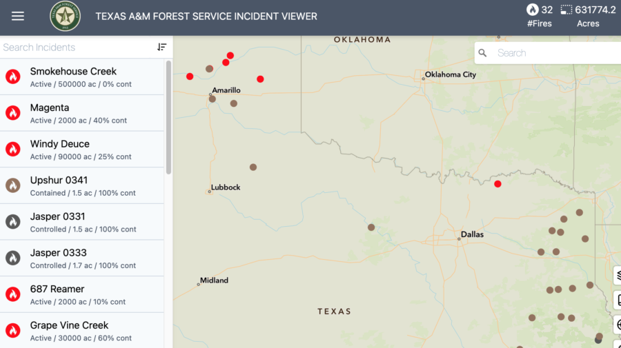
Fires burning in the Texas Panhandle and in Oklahoma have evacuated towns and killed at least one person. The 850,000-acre Smokehouse Creek Fire started Monday and is now 3 percent contained; it’s the second-largest fire in the state’s history.


Wildfires in the Texas panhandle are burning rapidly across drought-parched miles of grassy fuels, threatening towns and evacuating residents. How did the state’s second-largest fire ever burn to well over a half-million acres in just a couple days?

Smokehouse
On the night of February 27 strong winds pushed the Smokehouse Creek Fire across several roads in the Texas Panhandle. Texas A&M Forest Service photo.

High winds and drought, mostly, according to the National Weather Service’s Amarillo office. The East Amarillo Complex in 2006 burned over 900,000 acres — in the same general location. Samuel Scoleri, a forecaster at the NWS, told Isabella O’Malley with the Associated Press that dry winters are fairly standard in the Panhandle, but temperatures on Tuesday were in the 70s rather than the usual 50s and 60s for late February. “It kind of just feels out of the ordinary,” he said, “considering at the top of the month we had places get almost half a foot of snow down south.”

Politico reported that the largest of the fires, the Smokehouse Creek Fire, closed highways and a nuclear weapons site. The Pantex facility for assembling and disassembling the country’s nuclear arsenal shut down operations Tuesday night as fires burned near its facility 30 miles east of Amarillo. Pantex issued a statement online saying it had paused operations until further notice.

Texas Panhandle fires
Smokehouse Creek Fire 02/27/2024

The Smokehouse Creek Fire near Stinnett was first reported Monday evening;  USA Today said by Wednesday the fire had grown to about 500,000 acres — twice its estimated size on Tuesday evening — and was still at zero containment, according to the Texas A&M Forest Service.

ABC7 News reported that Texas Governor Greg Abbott announced a disaster declaration yesterday for 60 counties, including all 26 counties in the Panhandle.

Texas fire map
Texas fire map

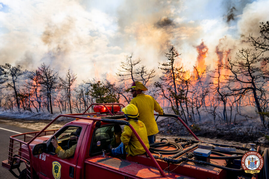
Officials are warning those who evacuated from the town of Fritch ahead of the Smokehouse Creek Fire that destruction there is considerable. “People who live in the Fritch area are probably not going to be prepared for what they’re going to see as they pull into town,” said Deidra Thomas with the Hutchinson County Emergency Management. “There are still homes that are on fire.” The main road into the south side of Fritch is still closed.  “Right now, we can’t let you in,” she said. “It is not safe to do that.”

Texas fires 02/28/24
Wildfires northeast of Amarillo in the panhandle, 06:00 EST 02/28/24 28, 2024. The largest, the Smokehouse Creek Fire, is estimated at 500,000 acres.

The governor also directed the Texas Division of Emergency Management (TDEM) to activate emergency response resources for local firefighters battling the multiple fires. “I issued a disaster declaration today to ensure resources are deployed to areas in the Texas Panhandle,” said Abbott.

Strong winds, unseasonably high temperatures, and dry grass are fueling the fires. Hot and dry and windy conditions should continue in the region in the coming days.

FIRE DANGER: Texas A&M Forest Service

Dry conditions and above-normal temperatures resulted in parts of the state facing increased fire risks, according to the Texas A&M Forest Service. Several wildfires across the Panhandle started on Monday, and the Forest Service responded to 13 new requests for assistance on wildfires burning nearly 80,000 acres across the state. CNN reported that the Smokehouse Creek Fire burned 500,000 acres in under 48 hours and forced evacuations in multiple counties. That’s more acres than the combined total of all Texas fires for 2023. Numerous homes on the perimeter of the town of Canadian were burned, Hemphill County Judge Lisa Johnson told The Canadian Record.

The Associated Press reported that fires tore through sparsely populated counties on the High Plains dotted with oil rigs and cattle ranches. By this morning wind speeds had decreased and the humidity has risen. Northwest winds are predicted throughout the morning, shifting to the east around 6 mph late in the afternoon, then to the south late in the day. Forecasters warned there’s also potential for wildfire fire activity in East Texas, the Rolling Plains, and western Cross Timbers, and fire conditions will likely pick up and increase again by the weekend.

There are currently 63 counties with burn bans in place.

 ~ Thanks and a tip of the hard hat to Jim, Brian, and Patrick.

California insurance rules change

California Insurance Commissioner Ricardo Lara said this week that insurance companies in the state will soon be allowed to factor in climate risks including wildfires in their insurance rates — if they increase their underwriting in at-risk areas to wean consumers off state-funded coverage.

Reuters reported that in the last year or two, seven of the state’s top 12 insurers have paused or restricted new business, including State Farm and Liberty Mutual, and the government’s Fair Access to Insurance Requirements (FAIR) Plan, intended as an insurer of last resort, has grown to a 3 percent share of California’s market.

Dixie Fire at Greenville, CA, 2021
Firefighters on the Dixie Fire at Greenville, CA, 2021. Jay Walter.

“We are at a major crossroads on insurance after multiple years of wildfires and storms intensified by the threat of climate change,” Lara said.

Unlike other states, according to an ABC News report, California does not allow insurance companies to consider current or future risks when setting the rate for an insurance policy. Companies can consider only what’s happened on a property in the past to set the price.

And insurers say that restriction makes it difficult to accurately price the risk.

On Thursday, Lara said California will write new rules to let insurers look to the future when setting their rates. “Modernizing our insurance market is not going to be easy or happen overnight,” he said. “We are in really unchartered territory and we must make difficult choices when the world is changing rapidly.”

The rule change is not all good news — it could mean higher rates for homeowners who have already seen dramatic increases. Eight insurance companies in California have requested increases of at least 20 percent this year, according to the California Department of Insurance.

Harvey Rosenfield, the author of a 1988 ballot proposition that regulates insurance rates, said Lara’s announcement “will dramatically increase homeowner and renter insurance bills by hundreds or even thousands of dollars.”

El comisionado de Seguros de California, Ricardo Lara, dijo esta semana que a las compañías de seguros del estado pronto se les permitirá tener en cuenta los riesgos climáticos, incluidos los incendios forestales, en sus tarifas de seguro, si aumentan su suscripción en áreas de riesgo para que los consumidores dejen de recibir cobertura financiada por el estado.

Reuters informó que en el último año o dos, siete de las 12 principales aseguradoras del estado han detenido o restringido nuevos negocios, incluyendo State Farm y Liberty Mutual, y el Plan de Acceso Justo a los Requisitos de Seguro (FAIR, por sus siglas en inglés) del gobierno, pensado como una aseguradora del último año. resort, ha crecido hasta alcanzar una cuota del 3 por ciento del mercado de California.

Northeast News: RxFire, highway closure, and drone warnings

April in New Jersey was dry and windy enough for numerous Red Flag Warnings this past week, but the state Forest Fire Service still pulled off a prescribed burn and contained a wildfire.

NJ Forest Fire Service firefighters Log Swamp Fire 20130416
New Jersey Forest Fire Service firefighters patrol the line on the Log Swamp Fire. Photo: NJ Forest Fire Service.

Another New Jersey fire, the Kanouse Fire, burned 1000 acres in northern New Jersey, leading to evacuations — of five homes and 100+ animals from the Echo Lake Stables. Embers were reported to have started fires a half mile across Echo Lake, with the fire staffed by multiple agencies.

Though fire danger has been high to very high statewide in recent days, fire restrictions have been lifted in two of the three statewide zones as today’s calmer winds reduced fire risk.

Today’s date also marks 60 years since New Jersey’s “Black Saturday” on April 20, 1963, when 30-50 mph winds, humidity in the low 20s and temperatures in the low 80s fanned the rapid spread of 31 major fires that burned 190,000 acres, destroyed or damaged 400 structures, and evacuated 2500 residents.

Meanwhile, in Pennsylvania, after a week with the entire state in high fire danger, the southern and central zones are now in high fire danger and the rest of the state is classed as moderate.

This past weekend, according to Lehigh Valley Live, the 4000-acre Crystal Lake Fire east of Mountain Top led to the closure of 20 miles of the Pennsylvania Turnpike between the Poconos and Wyoming Valley interchanges.

Also during the weekend, a drone-airspace intrusion on the Peter’s Mountain Fire in Dauphin County was reported by WGAL-TV.  The report reminded people that interfering with firefighting operations on public lands, per the Federal Aviation Administration, can carry a 12-month prison term, and drone pilots who interfere with wildfire suppression could also receive a fine of more than $37,000.

Chile: Wildfires intensify, disaster impacts expand

Satellite analyses and Twitter reports indicate a rapid growth of disastrous wildfires in south-central Chile yesterday (February 3) and overnight.

In the past 24 hours, satellite-based estimates based on NASA FIRMS data  indicate that the largest fire spread 80 kilometers (50 miles) west and northwest, impacting an area of nearly 100,000 hectares (230,000 acres). The fires appear to have spread from Renaico northwest toward the Pacific Coast city of Lota, while burning past Santa Juana and likely crossing north over the Biobío River.

In this NASA FIRMS map, the oldest yellow heat signatures are 24 hours or earlier, the most recent are red.

24-hour fire spread of largest fire in the Santa Juana are of Chile on Feb. 4, 2023. NASA FIRMS.
24-hour fire growth along a 80 km/50 mile line of the largest fire in the Santa Juana are of Chile on Feb. 4, 2023. NASA FIRMS.

A larger map shows 24-hour fire detections for the affected regions of Biobío and La Araucanía. (And a reminder, as the FIRMS mapping tool, these heat signatures may overestimate fire size and activity, in part due to smoke columns and other factors.)

Overview of active fires in south-central Chile for the past 24 hours. Feb. 4, 2023. NASA FIRMS.

The fires detected by satellites are being confirmed via social media updates. As @HotshotWake reported via Twitter …

Also from February 3, @zoom_earth shared a satellite stream of fires and smoke…

The Associated Press reported that the death toll as of February 4 has risen to 22 with more than 500 injured. The state of catastrophe has expanded to include the La Araucanía region, which is south of Ñuble and Biobío regions that were already in a catastrophe declaration.

Moccasin Hill Fire more destructive than initial estimates

When it burned through a rural southern Oregon subdivision on Sunday, the Moccasin Hill fire destroyed many more homes than fire officials initially reported.

Officials announced Wednesday that the fire destroyed 33 structures, up from the initial estimate of 20.

The Moccasin Hill fire ignited on Sunday, and prompted hundreds of people to evacuate from a rural subdivision outside of Sprague River, Eugene-based TV station KVAL reported Wednesday. As the fire spread rapidly over the weekend, officials first estimated that it destroyed six homes and 14 outbuildings.

But on Wednesday officials discovered an additional 17 destroyed homes, and some 16 destroyed outbuildings within the subdivision.


The structures were all damaged on Sunday, when the fire first broke out. As of Wednesday, the fire had burned 2,500 acres. Crews have established a full containment line around the fire but are working toward the center to put out hot spots.

The cause of this fire is still under investigation.

Oregon, like much of the West Coast, has been drought-stricken for months. The U.S. Drought Monitor shows that Klamath County, the Moccasin Hill fire is burning, is almost entirely in a severe drought.

As we reported on Tuesday,  more than 100 wildfires ignited in an Oregon lightning storm on Sunday.

Dozer accident injures one on California’s Monticello Fire


A person has been hospitalized after a bulldozer overturned while digging line on the Monticello Fire, the latest growing blaze in Northern California that ignited on the Fourth of July.

The dozer overturned around 1:30 p.m. PDT on July 6, while cutting line on rugged terrain along the fire’s northern perimeter, local media reported. 

The person was taken “as a precaution” to Kaiser Permanente’s Vacaville Hospital Trauma Center nearby. CALFire had issued no further updates on injuries as of Monday afternoon.

The Monticello Fire started around 9:30 p.m. PDT on Friday, just outside the town of Winters, on the southeast shore of Lake Berryessa. It grew rapidly to nearly 7,000 acres by Monday morning, and had forced the shut down of portions of California State Highway 128. The fire also triggered evacuations of several neighborhoods and is currently threatening around 40 homes.