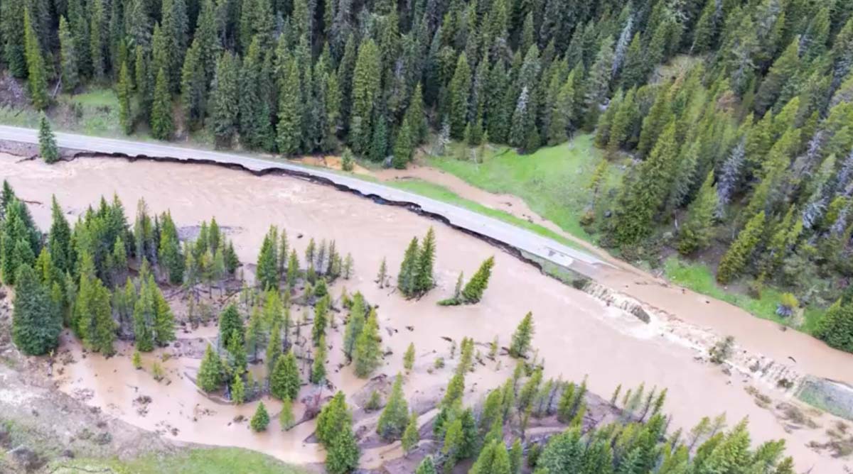
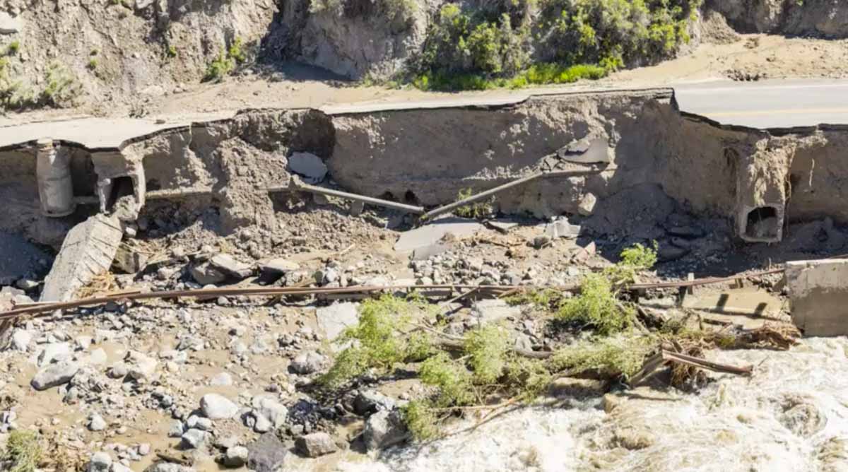
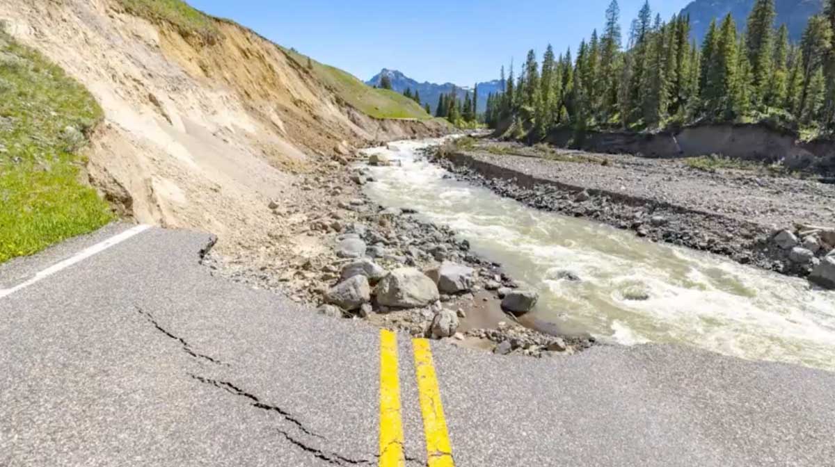
June 13, 2022 flood in Yellowstone National Park. YNP image.
Yellowstone National Park released a video yesterday describing the massive damage to the park’s infrastructure that occurred June 13 when unseasonably warm weather, melting snow, and very heavy rain produced widespread flooding across the north end of the park. Yellowstone Digital Communications Specialist, Jake Frank, gives his first-hand account of the 500-year flood event.
These photos are still images from the video below.
June 13, 2022 flood in Yellowstone National Park. YNP image.June 13, 2022 flood in Yellowstone National Park. YNP image.June 13, 2022 flood in Yellowstone National Park. YNP image.
Funded by a grant from REI Co-op and the National Park Foundation
Still image from the video below.
A National Park Foundation grant helped launch a pilot program working with conservation corps in California and Montana to create two women’s fire corps crews in Yosemite and Grand Teton National Parks. Much of the funding is a result of a very large donation from the REI Co-op.
The first video was filmed near the beginning of the fire season and the second checks in on the crews later. To change the resolution of the video, click on the screen-like icon at lower-right.
Map showing the location of the Fishhawk Fire. The red line was based on a USFS mapping flight at 8:19 p.m. MDT September 3, 2019. The red dots represent heat detected by a satellite at 2:12 p.m. MDT September 4, 2019.
The red dots on the map above represent heat detected on the Fishhawk Fire by a satellite at 2:12 p.m. MDT September 4, 2019. It is uncertain if they indicate actual surface spread of the fire toward the southwest, or if the heat was detected in an intense convection column in the atmosphere above the fire.
The smoke in the upper atmosphere was blowing off to the east, but perhaps lower level local winds, an up-canyon breeze, could have pushed the smoke and the fire to the south. During the fixed wing mapping flight at 8:19 p.m. on September 3 there was intense fire activity on the south edge of the fire.
(To see all articles on Wildfire Today about the Fishhawk Fire, including the most recent, click here.)
The Fishhawk Fire is 38 miles west of Cody, Wyoming, six miles east of the east entrance to Yellowstone National Park.
Scroll down to see more maps and information.
(UPDATED at 1:42 p.m. MDT September 4, 2019)
3-D map showing the location of the Fishhawk Fire at 8:19 p.m. MDT September 3, 2019, looking north.. Based on data collected from a USFS mapping aircraft. The orange shading indicates intense heat.
A mapping flight Tuesday night found that the Fishhawk Fire 38 miles west of Cody, Wyoming spread up to about one-quarter mile in all directions Tuesday except on the east side where it has reached a steep hog-back ridge 10,000 to 11,000 feet above sea level.
A Type 2 Incident Management Team will in-brief Wednesday prior to assuming command of the fire.
The resources assigned to the fire as of Tuesday evening included no hand crews, 3 engines, and 3 helicopters for a total of 29 personnel.
The 4,581-acre fire so far is confined to a north-south drainage that has a similar high elevation ridge on the west side. The fire is not being fully suppressed, so it is possible that firefighters are expecting the 10,000-foot ridges with light fuels to contain the perimeter on the east and west sides.
About 3.5 miles to the north is a highly-traveled highway, 14/16/20, leading from Cody to the east entrance of Yellowstone National Park. If it crosses the highway it would be burning on primarily south-facing slopes which would normally be very conducive to additional fire spread. However it would most likely be burning in the footprint of the 2008 Gunbarrel Fire that burned at least 67,000 acres. The light vegetation in the fire scar would present less resistance to control. Like the Fishhawk Fire, the Gunbarrel Fire was not suppressed. On August 15, 2008 the Shoshone National Forest had a plan for the maximum manageable area to cover 416,000 acres.
Map of the Gunbarrel Fire (bottom-center) August 3, 2008. At the time it was about 22,000 acres. Map from Wildfire Today. Click to enlarge.
In their long term plans, fire managers on the Fishhawk Fire should plan for extreme winds. On August 28, 2008 the Powell Tribune wrote this about the Gunbarrel Fire :
“The winds are just howling,” Clint Dawson said Wednesday, describing the wind’s rate around the Gunbarrel Fire.
Dawson is the zone fire manager for Shoshone National Forest.
In the valley — in the vicinity of the newly-relocated Gunbarrel Fire camp at Buffalo Bill State Park — the wind was gusting to 40-60 mph in the early afternoon on Wednesday. The new incident command camp is just above the reservoir west of Cody.
An aircraft flying over the fire Wednesday reported winds reaching 115 mph at 11,000 feet, Dawson said.
The fire was spotting on the east side of 12,000-foot high Trout Peak, according to an incident report.
A firefighter attacks a spot fire that jumped across the Gardner River near the North Entrance to Yellowstone National Park, July 26, 2019. NPS photo taken from near Highway 89.
An employee of one of the concessionaires in Yellowstone National Park was sentenced to three months of incarceration and $5,000 restitution for starting a fire.
Curtis J. Faustich admitted to dropping a lit cigarette on the ground while sitting at a picnic table and igniting the fire. Mr. Faustich appeared Tuesday, August 6, 2019, before U.S. Magistrate Judge Mark Carman at the Yellowstone Justice Center in Mammoth Hot Springs, Wyoming and pleaded guilty.
In addition to incarceration and a fine, upon release he will be subject to two years of unsupervised probation and prohibited from entering Yellowstone National Park for two years.
The fire started at about 6 p.m. on July 26 about one-tenth of a mile southeast of the North Entrance to the park between Highway 89 and the Gardner River 2.3 air miles north of the Montana/Wyoming border. It burned about four acres including a half-acre spot fire on the other side of the River.
Map showing the location of the fire that started near the North Entrance to Yellowstone National Park, July 26, 2019.
In a news release the Park’s law enforcement officers thanked the individuals who called the park’s 24-hour Tip Line at 307-344-2132 and provided timely incident details. The release stated that Mr. Faustich was charged with “discarding a lighted material in a hazardous manner”.
According to court records Mr. Faustich initially was given five citations:
Improper disposal of lighted material.
Failing to report an incident resulting in person injury or property damage.
Knowingly giving false information on application for permit.
Fire left unattended and unextinguished.
Presence in park area when under the influence of alcohol or controlled sub.
A fire started near the North Entrance to Yellowstone National Park, July 26, 2019. NPS photo taken from near Highway 89.
A scene from the Maple Fire in Yellowstone National Park, August 14, 2016. National Park Service photo by Jennifer Jerrett.
The National Park Service recorded audio of flames spreading at the heel, or the back side, of the Maple Fire August 8, 2016 in Yellowstone National Park. Recorded from about 15 feet away, the fire activity was not extremely intense, but at about 14 seconds, you’ll hear a small clump of lodgepole pine trees burst into flames, or “torch.” In listening to the 60-second audio file below, you might want to turn up the volume.
The Maple Fire burned over 40,000 acres northeast of West Yellowstone, Montana.
The Maple Fire burns at Yellowstone National Park in 2016. The fire affected forests recovering from the park’s historic 1988 fires. National Park Service photo by Jennifer Jerrett. The red line was the perimeter of the Maple Fire at 9 p.m. MDT Sept 2, 2016. The white line was the perimeter on August 29.
Mt. Holmes Lookout in Yellowstone National Park burned Tuesday, July 16, 2019. NPS photo.
The historic Mount Holmes Fire Lookout burned in Yellowstone National Park Tuesday after being struck by lightning. It had not been regularly staffed since 2007. The fire was reported Tuesday by the employee who staffs the Mount Washburn Fire Lookout.
The lookout is in the northwest corner of the park southwest of Mammoth Hot Springs.
Mt Holmes lookout in 1975; NPS photo by RJK.
The structure fire also damaged a park radio repeater.
Wednesday morning, July 17, three employees including the park fire chief attempted to fly to the 10,000-foot lookout via helicopter to assess the damage. However, the flight was diverted to a higher priority incident outside the park. While en route, the helicopter manager snapped a photo of the burned lookout.
Wednesday afternoon, staff attempted to fly to the lookout again but were grounded due to strong winds. Additional attempts will be made in the next few days.
“Built in 1931, and renovated in 1998, the Mount Holmes Fire Lookout maintained its historic-era role as one of Yellowstone National Park’s staffed lookout stations until 2007″,said Yellowstone National Park Deputy Superintendent Pat Kenney. “The building was eligible for inclusion on the National Register of Historic Places, both for its significance in early park resource protection efforts, and as an outstanding example of the rustic architectural style that typified early park architecture. We are disappointed that this historic structure, as a window into the past, is gone.”
The Mount Washburn Fire Lookout is currently staffed seven days a week, mid-June through mid-September. If warranted, three additional lookouts can be staffed.
Thanks and a tip of the hat go out to Mr.Capt. Typos or errors, report them HERE.