I ran across an interesting web site the other day called Wildland Fire Air Quality Tools. It has some very useful devices for predicting and analyzing smoke, wind patterns, and air quality.
There is no obvious branding on the site (the base web address is http://firesmoke.us), but the Contact Us page lists two US Forest Service employees, Pete Lahm and Sim Larkin. The About This Site page says:
The meteorological and air quality tools provided here are intended to support wildland fire decision making and integration of air quality assessments. This site integrates these tools with the Wildland Fire Decision Support System (WFDSS) in order to enable easy workflow with WFDSS. This integration is still in development and ongoing.
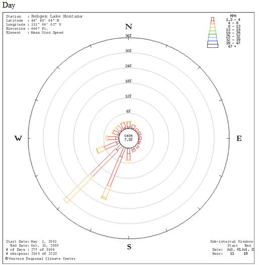
One of the more interesting tools on the site is one that will display a “wind rose” based on the location of your choice. If you enter a lat/long it will access data from the nearest RAWS to draw wind roses for a one month period, one for daytime and another for night. As you may know, a wind rose shows the historic wind direction and speed. Here is an example for West Yellowstone, Montana. It shows average wind speed and direction for the month of July during the day, based on data from 2001 to 2009. About 32% of the time the wind is from the southwest and about 22% of the time it’s from the south-southwest. About 14% of the time the wind speed is 8-13 MPH from the southwest.
Mapping shortcuts
You will need a lat/long to use the tools above, but you’re in luck because I discovered a quick way to determine the lat/long anywhere using a new “Labs” feature in Google Maps. But first I’ll tell you about another new feature in Google Maps that will help you navigate more quickly to a specific location.
On the Google Maps page, click on “New” at the top of the page. It will then list some new optional features in “Google Maps Labs”. If you Enable “Drag ‘n’ Zoom“, you can drag your mouse cursor to draw a box, then it will zoom to that box. To use this feature, click on the new magnifying glass icon that will appear on the left side of the map page under the “+” and “-” scale bar. Each time you want to draw a box to zoom, you’ll need to click that icon again.
Then scroll down in the Labs options and Enable “LatLng Marker” (not LatLng Tooltip). Click Save Changes. This option will post a “mini marker” showing the lat/long when you right-click on the map and choose “drop LatLng Marker”.
You’re welcome.


The Wildland Fire Air Quality Tools were put together by the AirFire team out of the US Forest Service PNW Research Station. Its the group Sue Ferguson put together; the same group who developed the BlueSky smoke modeling framework.
Thanks Andrew.
Bill