Updated at 12:22 p.m. June 4, 2011

The Wallow fire in southeastern Arizona, one of two huge fires burning in the area, spread an additional four to eight miles to the north on Friday partially due to long-range spotting, forcing more evacuation notices. The residents in the communities of Alpine and Nutrioso had been previously forced to leave and those in Greer were given a pre-evacuation notice on Friday. The residents of Blue River have been evacuated by Greenlee County officials. Inciweb has more information about evacuations.
An 8:30 a.m. update on June 4 from the incident management team included this information:
The fire advanced to the north and north-west and impacted Big Lake Lookout but not the Big Lake Recreation area. The has fire crossed the 249 road. The perimeter of the fire is close to Nutrioso and Mongollon rim but has not gone over yet.
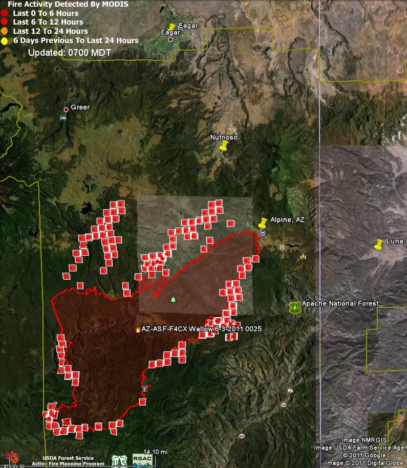
Making some rough measurements based on the map showing heat detected by satellites early Saturday morning, the fire at that time was approximately 4 air miles from Nutrioso, 9 miles from Greer, 15 miles from Eagar, and 11 miles from Luna, NM. These distances are estimates based on satellite data.
The Wallow fire burned an additional 14,600 acres on Friday, bringing its total to 120,600 an estimated 140,000 acres according to InciWeb. This makes it the third largest in state history, behind 2002’s 469,000-acre Rodeo-Chediski and 2005’s Cave Creek fire which burned 248,000 acres. The Willow fire now stands at number four, having burned 120,000 acres in 2004.
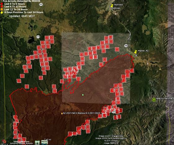
Below is a zoomed-in map showing the north half of the Wallow fire.

A call center has been established by the White Mountain Joint Information Center for information, including evacuation information, regarding the Wallow fire. Their phone number is (928) 333-3412, and their web site is 593.org. InciWeb is another source.
There are two “weather cams” that may occasionally have a view of the smoke. One is at Springerville near Eagar, about 15 miles to the north, and the other is at Greer, about 9 miles north of the fire. Click the “Time-Lapse” buttons to see earlier images.
The other large fire burning in Arizona is the Horseshoe 2 fire, near Portal.
Weather
The weather forecast for the Nutrioso area just north of the fire does not look favorable for the firefighters. On Saturday afternoon the winds should be out of the southwest at 21 mph with gusts up to 30 and a relative humidity of 8%. The winds are expected to decrease to 1-3 mph during the night but on Sunday afternoon increase to 17 with 26 mph gusts along with a RH of 6 to 25 percent. There is a chance of thunderstorms Sunday afternoon through Monday afternoon.
===============
We posted updated information about the Wallow fire at 9:30 p.m. on June 4.
Thanks Dinos


This fire is taking place in one of the most remote parts of Arizona’s high country so the damage will be very little if it remains out of the small towns. Its my favorite camping spot. The kp fire area around 8 years ago now has lots of berry bushes, oaks and 10 ft aspen! More beautiful than ever before and more wildlife too. The State is sure losing alot of revenue from burned trees that could have made billions in a future logging industry. Fires are part of the natural cycle of regeneration of forests from overcrowding. Putting out all those small fires in the past will only make bigger fires down the road. Pray that the firefighters don’t get too close to the danger and focus on the firelines where towns are only.
Thank You-to the firefighters,and law enforcement for doing a great job.It makes me sick that careless people can create a monster like this. To all of the great men and woman out there who are risking it all,again I say Thank You.
Thanks for the information on this site. I have property in Nutrioso and it looks like the fire is headed right at it . . . beautiful country, what a shame. Started building a home this month on the lot. Sitting in Tucson, waiting to find out if I will be able to continue, or if my lot will consist of ash and blackened stumps. I spoke with the president of our homeowner’s association, and I guess this fire was man-made.
There doesn’t seem to be an explanation of the little red rectangles on each map. Great map otherwise
The red squares represent heat detected by satellites.
The information is much needed an useful. I would really like to see a more outstretched area of the fire, and more of the surrounding areas as well.
Thank You and God Bless those who are putting themselves in harms way to try control this monster of a fire. Praying that they all return to thier families safely when this is over.
Thank you – so difficult to get accurate information and this map helps. Back in Tucson with fingers crossed – not much else I can do at this stage apart from hope that lives and homes will be spared. My house is in Dry Valley, Nutrioso.
Thank you so much for the updated map. We own property in Nutrioso and are sitting on pins & needles trying to find out how it is going up there. I am praying for this gorgeous land to survive. 🙁
Thank you to everyone working hard to contain this fire. I hope that this will help wake everyone up to the fact that we desperately need to start thinning our forests.
Thanks for the updated distances to area towns. Sunday, Monday could be ugly with isolated thunderstorms in area.