Update at 1:28 p.m. MT, June 12, 2011
From the Wallow fire incident management team:
Apache County Sheriffs Office Lifts Evacuation of Springerville, Eagar and South Fork
On Sunday June 12 at 10 am, the Apache County Sheriffs Office, after consulting with fire officials, has lifted the evacuation for the residents of the Springerville, Eagar and South Fork areas.
It has been determined that fire conditions have diminished enough that they will no longer be a threat to the citizens of the towns.
It should be noted, however, that the smoke still poses serious health hazards as has been outlined by Chris Sexton, Apache County Health Director, and the smoke problems may continue for weeks.
Because of the health problems associated with the smoke from the Wallow Fire, Apache County Public Health Services District and the Emergency Operations Center warns residents of Eagar, Springerville and South Fork that it would be best not to return to their homes until the concentration of smoke diminishes.
Alpine and Nutrioso are still under evacuation orders.
The full news release can be viewed at: http://593info.org/?p=1289
===========================================
Update at 11:33 a.m. MT, June 12, 2011:
The Wallow fire incident management team at 10:51 a.m. released their “8:00 a.m.” update. The size of the fire increased by about 13,000 acres to 443,989 acres, and it is still reported to be 6% contained.
- Total personnel: 4,311, including 24 hot shot crews and 84 other hand crews
- Residences destroyed: 29 and 5 damaged (4 commercial structures destroyed)
- Resources include: 15 Helicopters, 5 Air Tankers available; 334 Engines; 66 Water Tenders; 27 Dozers
Here is an excerpt from their update, which for some crazy reason was sent out as a GoogleDoc, rather than a format that could be more easily utilized:
The fire is 6% contained. Last night firefighters finished burnout between Forest Road (FR) 275 and FR 220 northeast of Alpine; burnout completed near South Fork; and a 3-mile burnout operation was completed in the Turkey Creek drainage along FR 281 toward Blue Creek. Good progress continued along the southwest and west flanks of the fire.
Today:
Burnout operations will continue SE along FR 220 to tie in with State Hwy 180, northwest of Luna, NM. Burnout preparations will continue along FR 74 and Trail 33 through Malay Gap and along FR 116. Structure protection, burnout and mop-up operations to strengthen containment lines and patrol for spot fires will continue.
A Red Flag Warning has been issued for today from 11 am to 8 pm, SW winds 15 to 20 mph, gusts to 40 mph; relative humidity 5-10%.
Public Information:
The public may call the following numbers for area-specific fire information:
- Springerville, Eagar, Greer, Alpine Information: (928) 333-3412, (702) 308-3238, (702) 308-3357, and (702) 308-8227
- Luna and Reserve NM Information: (575) 533-6928
- Areas south and west of the Fire: (928) 205-9884
Information is available at:
- InciWeb
- Twitter: http://www.twitter.com/AS_NF
- Flickr (photos): http://www.flickr.com/apachesitgreavesnf
InciWeb is still down. The NPS, USFS, USFWS, BLM, and BIA need to make it a priority to fix the infrastructure supporting InciWeb, so that it can be robust enough to work even when fires are burning, which is the only purpose of the site.
================================================

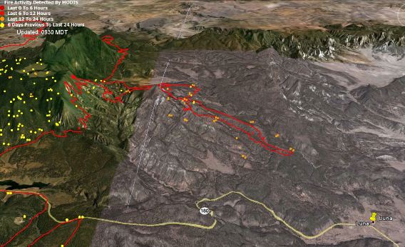
On Saturday, firefighters on the Wallow fire, most of which is in eastern Arizona, continued their backfiring operation across the state line in New Mexico. As of Saturday night they had completed over six miles of firing, most of it along Jenkin Creek Road and Forest Road 220, working southeast toward the community of Luna, NM, population 246. As of Saturday night they had progressed to within about two miles of Luna.
The purpose of the backfiring is for the controlled fire they are setting to remove the vegetation, the fuel, ahead of the main fire which is actively spreading towards the fire they are igniting. If everything goes as planned, the two fires will burn together and that eight-mile section of the fire will be contained.
Unfortunately, InciWeb, which has been having problems for the last couple of days, is down again Sunday morning, and the Wallow fire incident management team has not sent out any updates since Saturday afternoon. At that time the size was 430,171 acres and it was 6% contained. A revised acreage will probably show that the fire has grown by 10,000 to 15,000 acres.
On Saturday, on the west side south of Greer, the fire burned intensely in some areas while it continued to move slowly on the south side. The north and northeast sides of the fire were not very active on Saturday.
There were 15 helicopters and six air tankers assigned or available on the fire yesterday. Tanker 911, the DC-10, made two sorties to the fire.
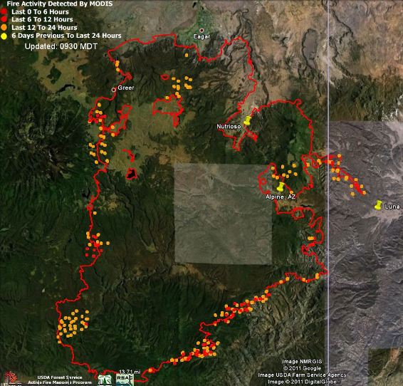
Below are two maps of the Wallow fire. The second one is a 3-D map that shows the area on the east side where the firefighters are conducting the backfire in New Mexico. The vertical white line is the AZ/NM border.


Good Day;
I love Arizona and specially the beautiful pine forests. I drove through the Rodeo fire twice. How much of the state’s pine forests have these two of the state’s largest fires burned? It looks like these two fires have burned almost a quarter of the band of pine forest below the Mogollon Rim. Now it looks like the Horseshoe Two fire has burned the whole pine forest island around Silver Peak. This is a great loss to everyone.
Have a nice day,
Pat
I think you have hit the nail with your definition Bill. Another way to look at it is this; burning out is part of line construction and the decision to carry it out is made at the resource boss level(engine, crew). Back firing is a larger scale operation, and responsibility for making the decision to engage lies with the OPS section Chief, or branch director.
Inciweb goes down all of the time. It would be nice if they would fix it!! This has been a problem for several years and we where told two years ago that it had been taken care of…
The finger going into New Mexico was a back fire? wow
Inciweb works on the homepage but clicking on the incident name does not work, however it says it was updated 36 min ago and the acreage was at 443,989. Nice call, thats right within your estimate!! 🙂
Now it works. Sheesh. Well same acreage and claiming 6% contained.
🙂