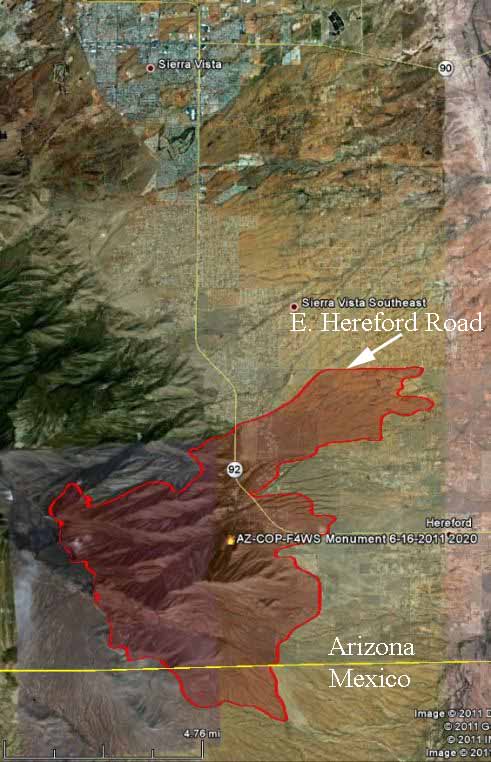
Update at 12:30 p.m. MT, June 17, 2011: replaced map with updated version.
================================
The Monument fire in southern Arizona grew substantially on Thursday, expanding further into the Huachuca Mountains and crossing Highway 92 a second time. It has now blackened a total of 18,580 acres and is 15% contained.
Below is a map of the Monument fire.

Here is an excerpt from a report on InciWeb, dated June 17 at 8:00 a.m.:
Yesterday’s Activity: Predicted weather conditions and extreme fire behavior resulted in the fire crossing highway 92 at Stump Canyon around 2pm. Firefighters kept the fire south of Herford Road. Tankers and helicopters dropped water and retardant. No structures were lost east of highway 92. Crews continued to look for potential fire danger to structures, developing protection plans for homes. Firefighters continued to reinforce Forest Road 61 on the southwest part of the fire. Fire activity increased in Coronado National Memorial, and crews continued to secure the fire line and mop up hot spots. There was one injury as a result of smoke inhalation.
Today’s Plan: Due to extreme dry fuel conditions, high winds, and single digit relative humidity, a Red Flag Warning is in effect. Firefighters and fire engines are prepared for extreme fire activity. Additional firefighting resources will join the night shift. Crews will finish mop up east of Highway 92. Crews will coordinate efforts will Fort Huachuca fire protection resources to look for opportunities for potential control lines. Crews will prepare fire line from Hunter Canyon to Carr Canyon to continue structure protection. Helicopters and air tankers will be utilized to drop water and retardant to help slow the fire. A structure protection group will continue to look for potential fire danger in the Hunter Canyon area. Crews will work to hold the fire along Forest Road 61 on the southern edge of the fire. Crews will prepare Forest Road 4781 for potential burnout operations.
xxx


29 years as a fire capt with calif dept of forestry (dozer operator ,fire crew captain ,station captain )been there and done that like is was yesterday.retired with severe neck and back injury 3 level neck fusion
3 level lower back fusion.I miss the job.Their are doing a great job. keep one foot in the burn.
.