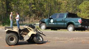
Dozer transport burned on Idaho fire

Salt fire 8-28-2011
The title of this photo on InciWeb is "Aug 29 fire reaches edge of safety zone". And the caption there reads: "Waiting it out. The truck was not damaged by the fire." Photo by Todd Camm.

A dozer tranport burned on Monday, August 28 on the Salt fire southwest of Salmon, Idaho.

From Inciweb:

Salmon, Idaho, Aug. 29, 2011-The Salt fire, 16 miles southwest of Salmon, made an estimated three-mile run on Monday, according to fire officials.

One “dozer transport,” a truck pulling a trailer used to haul bulldozers, was reported burned Monday afternoon, on the fire’s east side.

However, no firefighters were injured, officials said.

“We heard that one firefighter did pull out his fire shelter,” Bob Sommer, the incident commander said. “But, we understand that a safety officer took the firefighter to the safety zone.”

“Everyone made their way to the designated safety zone. Everybody is safe and accounted for,” Sommer said.

Sommer said there are no reported injuries.

It’s standard practice for firefighters to always have safety zones close at hand, Sommer said. Safety zones are areas already burned or otherwise lacking flammable material.

Forest Service officials have begun an investigation, Frank Guzman, forest supervisor of the Salmon-Challis National Forest said.

The Salt fire’s run was visible for much of the afternoon from Salmon, with large smoke columns rising high into the air throughout the afternoon.

Today the Salt fire is listed at 4,679 acres with 5% containment. More information is at InciWeb.

Salt fire smoke column
Salt fire smoke column. An undated photo on InciWeb. Photo by Matt Call

Thanks go out to Matt

Do us a favor. If you appreciate this article or others on Wildfire Today, click the +1 button at the bottom of the article to recommend it to Google. Thanks!

Dollar Lake fire on Mt. Hood

Dollar Lake fire
Photo by Photonut

The Dollar Lake fire burning on the lower slopes on the north side of Mt. Hood in Oregon is providing some excellent photo opportunities.

Photo Dollar Lake fire
Photo: Judybug

The fire was officially reported Monday night to be 600 acres, but on Tuesday, the fire reached 1,500 acres, according to Jeree Mills, a Northwest Interagency Coordination Center spokeswoman. Several campgrounds have been closed. Suppression of the fire is hampered by strong winds, heavy fuels, and long-range spotting. Firefighters are protecting the historic Cloud Cap Inn, a large building with a shake shingle roof, by wrapping it in fire shelter material.

Zenfolio has a gallery with some excellent shots of the fire taken by Dan Kleinsmith.

Comparing greenness to fire occurrence

Departure from average greeness map

Departure from average greeness mapI find it interesting to compare the departure from average greenness map to one that shows the locations of large fires that are currently burning. The departure from average greenness map portrays how green each pixel is compared to its average greenness for the current week of the year based on 1989-2003 data.

Current large incidents and fires August 30


Texas firefighter killed on ATV

Meyers fatality

An Angelina County volunteer firefighter in Texas was killed Sunday when he was responding to the Ebenezer Complex of fires. Tony Quinten Meyers, 38, died when his ATV collided with a truck driven by a Texas Parks and Wildlife Game Warden.

Meyers fatality
Photo: KJAS

According to the DPS accident report, Mr. Meyers was driving an ATV and disregarded a stop sign. He struck a Ford F150 truck driven by the Game Warden.

Our sincere condolences go out to the family and coworkers of Mr. Meyers.

Montana woman dies in grass fire

The Havre Daily News is reporting that a woman died Thursday, August 25 from burns that she suffered on a grass fire August 22 in northern Montana between Gildford and Kremlin.

A Hi-Line native injured in a fire south of Gildford Monday died Thursday morning at a hospital in Salt Lake City.

A spokeswoman for the University of Utah Medical Center told the Havre Daily News Thursday afternoon that NellieKim Sorenson died about 11 a. m. as a result of the burns she sustained in the fire.

A representative of the Kremlin fire department, one of several volunteer fire departments that responded, said Tuesday that Monday’s fire, south of U. S. Highway 2 between Gildford and Kremlin, burned more than 100 acres starting about 5 p. m. before it was extinguished about 7 p. m.

Additional details about the cause of the fire or how Sorenson was injured have not been available to the Havre Daily News so far.

The Great Falls Tribune reported that the victim “was identified as one of those who went to help firefighters.”

Our sincere condolences to the family of Ms. Sorenson.

Air tanker update

Tanker 262 at Aero-Flite in Kingman, Arizona

It was just two days ago that we wrote an article about air tankers, covering CAL FIRE’s new policy of restricting the use of their S-2s on federal fires and the deteriorated state of the federal air tanker fleet. But yesterday, August 27, there were two significant developments related to air tankers.

CL-215s at San Bernardino 

On August 26 late in the afternoon three CL-215s showed up at the San Bernardino airport. They are operated by Aero-Flite, Inc. out of Kingman, Arizona and are working on a federal contract. The company owns operates five CL-215s that have been used in Alaska, Minnesota, and by the Bureau of Land Management. They have already been used on two fires on the San Bernardino National Forest, the Mile and Oasis Fires, refilling at Big Bear Lake.

Tanker 262 at Aero-Flite in Kingman, Arizona
Tanker 262 at Aero-Flite in Kingman, Arizona. Photo: Aero-Flite

These CL-215s can scoop up to 1,400 gallons of water from from approved lakes and have the capability of mixing foam concentrate with the water while in flight, making it possible to drop Class A foam on the fire. The aircraft can also be filled with water while parked at an airport.

The primary differences between a CL-215 and CL-415 is that the latter has turbine engines, can hold about 200 more gallons, and has aerodynamic additions to the wings and empennage, or tail assembly.

DC-10 activated by the U. S. Forest Service

Almost two months after awarding a Call When Needed contract to 10 Tanker Air Carrier for their DC-10 air tankers, the USFS activated one of the Very Large Air Tankers yesterday. Tanker 910 arrived at McClellan Airport near Sacramento, California at 8:00 a.m. on Saturday and was dispatched to a fire near the Utah/Arizona border at 10:30 am. It made two trips and nine drops. Today it is being used on the Motor fire just outside the El Portal entrance to Yosemite National Park.

Television show about CL-215s

Has anyone else seen the show on the National Geographic Channel called Ice Pilots? It is a reality show about a company in northwest Canada that operates mostly vintage aircraft, including two CL-215s, a Lockheed L-188 Electra, a DC-3, a C-46, and a DC-4. There was a series of shows in which the company had sold the two CL-215s to the Turkish government and were attempting to deliver them to the buyer, flying them across Canada, the north Atlantic, and Europe.

One complicating factor was the lack of any deicing equipment on the air tankers, something they don’t usually need while working on wildfires. Another was having enough fuel to make it across the Atlantic, so the company was carrying flexible fuel bladders inside the aircraft to increase their range.

During the last episode I saw a few months ago the two CL-215s had made it to the east coast of Canada and were waiting for warm weather over the north Atlantic to begin the ocean crossing.

How Americans use social media during emergencies

How Americans Use Social Tools In Emergencies

How Americans Use Social Tools In Emergencies

This is an interesting graphic prepared by the American Red Cross that apparently contains the results of a survey. It is surprising that so many expect that social media is a method for communicating with emergency service agencies. What are the implications of this? Should the public be educated that Facebook and Twitter are not the best ways for contacting emergency services? Or, has that ship sailed already and there is no turning back? Should the emergency service agencies establish more of a presence on social media?

Rolling down steep terrain

Firefighters are not hired based on their writing skills, or at least it’s not the number one consideration. And we appreciate all fire updates and status reports, knowing that the people composing them are pressed for time and don’t have the luxury of being wordsmiths. But I enjoyed reading an update posted on InciWeb this morning about a high-profile fire in California. Here are two excerpts:

Type one hand crews continue to play a significant roll in steep terrain line construction.

I have rolled down more than one piece of steep terrain while constructing line.

And…

Local Law enforcement recommend procationary measures.

They get points on the second one for completely making up a word. Any suggestions on what the definition of “procationary” should be? How about this: Proactively taking a vacation thinking that evacuations may be ordered later.

Incident Management Teams activated for hurricane Irene (Updated)

Jim Giachino

UPDATE  at 9:06 a.m., August 28, 2011:

In case you are interested in how FEMA is reacting operationally to the response and recovery from Hurricane Irene, here is an excerpt from the FEMA Blog, written this morning:

What We Are Doing

Our immediate focus and priority, as we move from into the response and initial recovery phase, is to do everything we can to support first responders and emergency managers at the frontlines with efforts to keep residents and communities safe. Here’s a brief update on what we’re doing:

  • We’ve proactively positioned a total of 18 Incident Management Assistance Teams along the coast to coordinate with state, tribal and local officials to identify needs and shortfalls affecting potential disaster response and recovery.
  • Six national urban search and rescue teams, comprised of more than 500 personnel, are activated and ready to deploy if needed.
  • Community relations teams are being staged to support states along the East Coast. These teams, if needed, help inform disaster survivors about available services and resources.
  • Mobile Emergency Response System assets have been strategically located along the entire east coast to support emergency response communications needs.

===========================================

August 27, 2011:

Jim Giachino
Jim Giachino, IC

At least two Incident Management Teams have been activated in response to hurricane Irene. Jim Giachino’s Type 1 team from California will establish and manage a mobilization center at East Farmingdale, New York. Mr. Giachino is affiliated with the Chester Fire Protection District in California and is formerly the Forest Supervisor of the Mendocino National Forest.

A type 3 team will be assigned in the Boston area along with four saw crews. A type 2 crew will be assigned in the New York region.

The National Park Service pre-positioned three of their five all-hazard IMTeams. The Coast Guard staged six of their Disaster Assistance Response Teams, river-rescue units equipped with shallow-draft, flat-bottomed boats, in areas that were expected to be hit by flood waters.

FEMA has activated their Regional Response Coordination Centers in Boston (Region 1), Philadelphia (Region 3), and New York (Region 2) and pre-positioned 18 of their Incident Management Assistance Teams along the east coast. Six national urban search and rescue teams have been placed on alert in the event that search and rescue support is needed.

FEMA releases mobile app

FEMA app screen shot

FEMA app screen shotJust in time for hurricane Irene, the Federal Emergency Management Agency has released an application for Android mobile phones. Just put in the Android Market a couple of days ago, it has been downloaded less than 100 times. I tried it out and can see a couple of things that I would change, but generally it works pretty well.

Some of the features:

  • A disaster victim can apply for federal assistance right from their phone
  • Maps of Disaster Recovery Centers and shelters (the maps are a little buggy)
  • A frequently updated blog that contains the latest news about current disasters.
  • Pre-disaster information about being prepared.

The name of the app is “FEMA Federal Emergency Management Agency (FEMA)”. Do not confuse it with a similar looking app called “FEMA Mobile”, which is being distributed by a private individual, has advertisements, and merely links to the FEMA web site.

The app is free. FEMA is working on versions for Blackberry version 6 devices and iPhones, which should be available in a matter of weeks.