Apple fire, South Dakota. Photo, March 28, 2012 by Bill Gabbert
The Apple fire, 8 miles southeast of Custer, South Dakota, is winding down and firefighters are being released. The size is holding at 546 acres and the Incident Commander expects to call it 100% contained at the end of the operational period today.
Here is an update, posted on InciWeb at about 3:30 p.m. today:
Final Update: “Crews were able to get a good handle on the Apple Fire yesterday,” Lynn Kolund, Hell Canyon District Ranger said. By the end of the shift, 50% of the fire was contained. Kolund said if conditions warrant, they are expecting 100% containment tonight. Control lines held overnight and the fire acreage remained at 546 acres. “The wind helped to consume downed wood in the interior of the fire,” Kolund said. Air support did another fly over at 9:00AM this morning to assess the situation. A few small smokes remain within the fire.
Today many of the fire resources are traveling home. Remaining resources continue to mop up smokes and patrol the fire. Todd Pechota, Fire Management Officer, commended the firefighters for no injuries during the fire. “The safety record has been good, but it is not over until you are all safely home,” Pechota said.
The air tanker fleet managed by the U.S. Forest Service, NPS, BIA, BLM, and USFWS, has deteriorated over the last 10 years from 44 large air tankers on exclusive use contracts to the 11 we have today. As the climate changes, fire seasons are getting longer. Last year there were records set in Arizona and New Mexico for the largest fires in the states’ histories. In March of this year fires burning in Colorado and South Dakota competed for scarce air and ground firefighting resources. The number of unfilled orders for air tankers continues to increase. Congress regularly reduces the firefighting budgets of the land management agencies.
A firefighter on the Apple fire improves the fireline on March 28, 2012. Photo by Bill Gabbert
Firefighters on the Apple fire 8 miles southeast of Custer, South Dakota have completely lined the fire and burned out the indirect line we reported yesterday. The fire was first detected at about noon on Wednesday and started from a lighting strike on Monday.
Today the 132 firefighters will be mopping up, strengthening firelines, and mitigating the hazards from possible falling trees along Flynn Creek Road. The weather today and tomorrow will be challenging, with the relative humidity in the teens and 15 mph winds gusting up to 22 mph.
The two National Guard blackhawk helicopters have been released.
While the completed and burned-out fireline meets the definition of 100% containment, the Incident Commander is calling it only 15% contained. This has been a trend in recent years, with ICs confusing the terms control and contain.
The dispatch system has had to reach out far and wide to find resources for this 546-acre fire. We know of one engine crew in the Greater Yellowstone area that was dispatched Thursday night to the fire. Hand crews came from Montana and other states. Soon after it started on Wednesday, the IC requested two large Type 1 helicopters. One of the orders has been filled, and that was with a Kmax helicopter which barely (if that) qualifies as a Type 1. The other order was still unfilled as of Thursday night. The two large air tankers that arrived empty at Rapid City more than 6 hours after the first initial attack resources were dispatched had to be stolen from the Lower North Fork fire in Colorado. At the time that fire was reportedly “15% contained”, but as discussed above, containment percentages have become meaningless. The statistic can no longer be used for prioritizing fires.
The Jefferson County Sheriff’s Office says the reverse 911 system didn’t work as expected for the Lower North Fork fire in Colorado. The software company disagrees.
Activity on Colorado’s Lower North Fork fire is winding down.
The Wallow Fire burns near the Meadow Lodge as firefighters protect the historic structures on June 11, 2011. Photo by Chris Francis, U.S. Forest Service
Two cousins pleaded guilty Tuesday of accidentally starting the Wallow fire which became the largest fire in the recorded history Arizona. Caleb Malboeuf of Benson and David Malboeuf of Tucson were camping in the Apache Sitgreaves National Forest last May and went for a hike. They said when they left, they thought their campfire was out since they did not see any flames or smoke. On their way back to the campsite they smelled and saw smoke in the area. Investigators found their possessions at the campsite where the fire started and their vehicle at a trailhead about two miles away.
The Wallow fire burned 538,000 acres, most of it in Arizona near Alpine, Nutrioso, and Springerville, but it also burned into New Mexico near Luna. It burned 32 homes and 4 cabins burned and forced the evacuation of about 10,000 people. The fire started on May 29 and was contained on July 8. Wildfire Today covered the fire extensively.
Sentencing is scheduled for June 20. Due to a plea agreement, they are facing up to a year in jail and a $10,000 fine, but their attorney is arguing for probation instead of jail time.
The Jefferson County Sheriff’s Office has posted the much-requested “current verified list of structures damaged by the Lower North Fork fire”, as well as a map. All local home owners with confirmed damaged properties have been escorted to their property by the Jefferson County Sheriff’s Office. There are two homeowners who have not made it back to their property because they are coming from out of the area.
There was no perimeter growth today. The size remains at 4,140 acres and they are calling it 45% contained.
As of Thursday morning, the Lower North Fork fire southeast of Conifer, Colorado is 15% contained and has burned 4,140 acres. The number of homes damaged or destroyed remains at 27. The owners of 26 of the structures have been notified. Rich Harvey’s Type 1 Incident Management Team assumed command of the fire at 6:00 a.m. today. The local Type 3 IMTeam will continue to work with the Type 1 team.
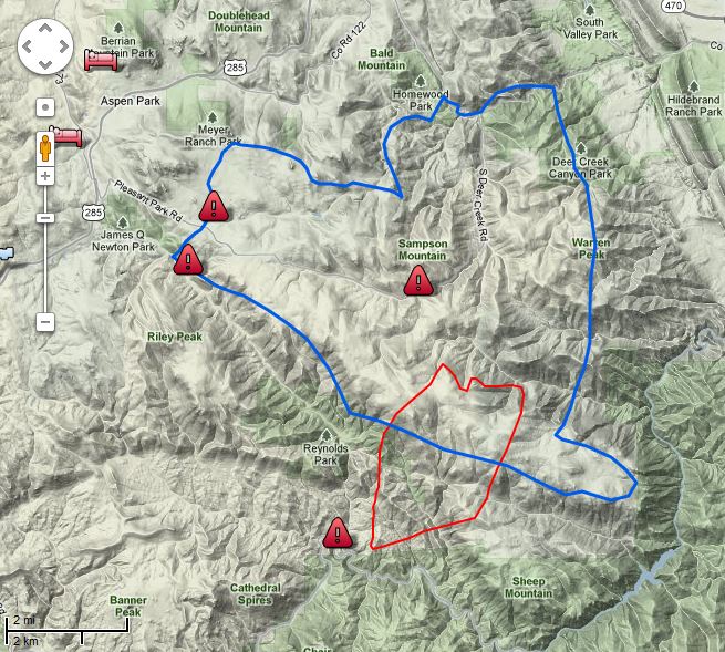
The map of the Lower North Fork fire below shows the perimeter (in red) as of 9:39 Wednesday night.
Map of Lower North Fork Fire. The blue line is the evacuation zone. The red line is the fire perimeter at 9:39 p.m. 3-28-2012. Map provided by Jefferson County Sheriff's Office
On Wednesday there were two large air tankers assigned, P2Vs, Tankers #44 and #45, but they were removed from the fire late in the afternoon and redeployed to the Apple fire south of Custer, South Dakota. (We were at the Apple fire yesterday.) There will be four National Guard Blackhawk helicopters assigned to the Lower North Fork fire today. Four helicopters dropped 49,000 gallons of water yesterday.
Residents seeking information about the status of their property within the fire evacuation zone may come to the Conifer High School, but the school is closed to the general public.
With the apparent cause of the fire being an escaped prescribed fire that was managed by the Colorado Forest Service, on Wednesday Deputy State Forester Joe Duda issued a statement that reads in part:
We want to express our deepest sympathy to those who have lost loved ones and those who have lost property, and we hope for the safety of crews as they continue to fight the fire.
On Wednesday the governor of Colorado suspended the use of prescribed burns by state agencies.
It is very early in the year, and early in the wildfire season, but already firefighters are competing for aerial and hand crew resources. There are not enough to go around, and they are not deployed where the fires are occurring. This is due in part to the diminishing budgets of the firefighting agencies, translated as fewer firefighters, and mismanagement of the federal air tanker fleet.
Other articles on Wildfire Today about the Lower North Fork fire:
On March 25 I sent emails to four Senators, one congresswoman, and the Senate Committee on Energy and Natural Resources. I took advantage of my right, and my responsibility, as a citizen to express my opinion on the pitiful state of our air tanker fleet. And I was not shy, which will not surprise the regular readers of Wildfire Today, about providing my analysis of how we got to this point, with the fleet only a shell of what it was 10 years ago, reduced by 75 percent. The land management agencies, and especially the U.S. Forest Service, own this debacle.
In addition to the Senate committee, which holds regular hearings in which wildfire issues are discussed, the recipients of my letters included Senators Ron Wyden and Lisa Murkowski.
It is probably a coincidence, but on March 27 and 28 numerous media outlets ran stories saying that four senators sent a letter to the Government Accountability Office asking the agency to review “the nation’s depleted fleet of firefighting aircraft and the remedies needed in the face of increasingly severe fire seasons.”
The senators that signed the letter were Sens. Ron Wyden, D-Ore.; Lisa Murkowski, R-Alaska; Jeff Bingaman, D-N.M.; and Dianne Feinstein, D-Calif.
If there are going to be any significant improvements in the air tanker fleet, it will have to be a political solution. The land management agencies, and especially the U.S. Forest Service, have proven that their strategy is “sit on our hands and make no tough decisions”.
If you have an opinion on this issue, let your senators and representatives know.
Here are some excerpts from the Associated Press article that appeared in newspapers and web sites around the country.
A group of Western senators says the U.S. Forest Service may not be moving quickly enough to build up and replace the fleet of aging planes that drop fire retardant on wildfires.
The senators asked the Government Accountability Office on Tuesday to evaluate whether the Forest Service has done a good job of analyzing the types and numbers of aircraft needed, the cheapest way to get them, new technologies, and where the planes will be based.
“Concerns have increasingly been raised that the federal agencies responsible for responding to wildland fires _ the Forest Service and four agencies in the Department of Interior _ do not have the appropriate number and mix of aircraft that will be needed for wildland fire suppression operations,” said the letter signed by Sens. Ron Wyden, D-Ore.; Jeff Bingaman, D-N.M.; Lisa Murkowski, R-Alaska; and Dianne Feinstein, D-Calif.
[…]
Last month, the Forest Service adopted a new strategy for replacing the fleet with newer, faster and more cost-effective planes.
[…]
Wyden complained that the Forest Service’s strategy is woefully lacking in specifics that would allow comparisons of different types and costs of aircraft so choices can be made. Meanwhile, a “perfect storm” is shaping up of dry weather and thick stands of forests that have not been thinned.
“Trying to get these tankers and the fleet ready for serious fire seasons seems to be almost the longest running battle since the Trojan war,” he said. “The West doesn’t have the luxury of just sitting around while everything goes up in smoke.”
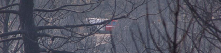
Looking north across Wind Cave National Park to the Apple fire, north of the park -- through a loooong, telephoto lens. March 28, 2012 at 5:40 p.m. MT.
UPDATE at 6:55 p.m. MT, March 29, 2012
Firefighters have a fireline around the entire fire, but portions of it are indirect. That is, the line is some distance from the fire, so firefighters have to burn out or backfire between the line and the fire in order to eliminate the fuel (or vegetation) in those areas. Until that is complete the firelines will not be secure. The two photos below that were taken on Wednesday showing firefighter Brice Stanton are examples, but on a small scale, of burning out unburned vegetation between the fireline and the fire.
More accurate mapping has resulted in a smaller reported size, which is now 500 acres, all but 30 of which are on U.S. Forest Service land, the rest being private. They are calling it 15% contained.
On Friday the weather will challenge firefighters and test the indirect firelines. The Weather Service is predicting 10 to 25 mph winds with gusts up to 35, and a relative humidity of 15%.
The USFS has produced a map showing the fire’s location.
At 10 p.m. last night the fire spotted across a dozer line and a road, and this morning is reported to be 515 acres and 15% contained. It is three miles southeast of Cicero Peak, and eight miles southeast of Custer, SD. The Incident Commander is Todd Hoover, from the Black Hills National Forest.
There are currently 2 Heavy Air Tankers, 1 Type 1 Heavy Helicopter (KMAX) and a lead plane stationed at the Rapid City Air Tanker Base.
Map showing the location of the Apple fire
We will add more information as it develops today.
Monday’s lightning is suspected of starting a fire that showed up today between 1 and 2 p.m. at 11:38 a.m. north of Wind Cave National Park on the Black Hills National Forest in South Dakota. At the last report it had burned about 300 acres.
All photos were taken by Bill Gabbert on March 28, 2012 between 2:56 p.m. and 5:40 p.m.
The staging area.
During the early stages of the fire the Incident Commander was able to use a South Dakota National Guard Blackhawk helicopter and a Single Engine Air Tanker (SEAT) on the fire. Then the SEAT got taken away and used on a new fire about two miles south of Mt. Rushmore. Initially there were no large air tankers available, but several hours into the fire Dispatch told the IC that they had rounded up two large air tankers, apparently coming from a considerable distance away, and they would be landing empty at Rapid City Airport around 6 p.m. Two Type 1 helicopters were also ordered from some very distant locale. Crews were coming from Montana and other states. [UPDATE: the two large air tankers were “stolen” from the Lower North Fork fire in Colorado, leaving them with no air tankers.. At 4:30 p.m. on Wednesday that fire was 4,140 acres and only 15% contained.]
Welcome to the 2012 wildfire season. It’s still March and there are not enough aerial and hand crew resources where they are needed.
Four Jefferson County Deputy Sheriff officers were trapped in the Lower North Fork wildfire on March 26, 2011, southwest of Denver, but they escaped eventually, unhurt. This is an audio recording of some of the radio traffic from that incident, courtesy of 9news who got it from a scanner feed.
Click on the green arrow to listen to the recording.
Lower North Fork Fire. Credit: Jefferson County Sheriff's Office
(We will update this throughout the day on March 28 as developments occur.)
UPDATE at 12:30 p.m. MT, March 28, 2012
The reported size of the fire has been changed from 4,500 to 3,790 acres. This latest size was calculated from an infrared mapping flight that occurred at 10:30 p.m. on March 27.
The Jefferson County Sheriff’s office has reduced the number of damaged structures from 28 to 27. One of the recorded addresses was not accurate.
We have an audio recording of radio traffic from an incident that occurred on March 26 on the fire when four Jefferson County Sheriff officers were entrapped in the fire. They escaped unhurt, but the audio is gripping.
The Denver Post has some fascinating video that was shot by residents driving out of the fire. They said they did not receive a reverse 911 phone call warning.
=================================================
UPDATE at 9:23 a.m. March 28, 2012
The Jefferson County Sheriff’s Office has updated their map of the fire with data from 8:20 p.m., March 27. The fire perimeter in red. The blue line is the evacuation area as of 2:00 p.m. on March 27. We expect they will give us an updated acreage later.
Map Lower North Fork Fire 8:30 p.m., 3-27-2012. Jefferson County Sheriff's Office
The Jefferson County Sheriff’s Office released some updated information at 8:30 a.m. on Wednesday:
Overnight the fire was relatively stable. Fire crews made progress through the night in protecting structures. Today’s strategy is to gain containment around the fire while continuing to protect structures.
Today’s fire behavior is expected to be similar to yesterday but with slightly higher winds. The winds could result in more robust fire activity. The fire will also most likely become more intense as the temperature rises throughout the day. The fire has continued to exhibit a tendency to start spot fires in a wide area.
[…]
The Jefferson County Sheriff’s Office will continue to man road blocks around the fire perimeter. At this time we are not allowing anyone back into the evacuated regions.
The Sheriff’s Office said the estimated size is still 4,500 acres and that 28 structures have been damaged.
The Lower North Fork fire that is southwest of Denver and seven miles southeast of Conifer, Colorado, was relatively quiet during the night. The last official acreage that was released by the Jefferson County Sheriff’s Office for the wildfire was 4,500, and they reported that 23 homes have been damaged. An elderly couple was found dead near their home and one resident within the burn area is missing.
The map of the fire shows the fire perimeter in red, as of 11:00 p.m. on March 26. The blue line is the evacuation area as of 2:00 p.m. on March 27. We will provide an updated map as more information is provided.
Map Lower North Fork Fire. Jefferson County Sheriff's Office
The firefighters’ strategy on Wednesday is to switch from point protection to constructing fireline to begin containment of the fire. They had hoped to do that on Tuesday, but the weather and fire behavior did not cooperate, pushing them back into a defensive and structure protection mode. Containment is still listed at zero percent, and 900 homes are still under a mandatory evacuation order. On Wednesday three air tankers (two P2Vs and one single engine air tanker) and four helicopters (including two National Guard Blackhawks) will be working on the fire. More aircraft are on order.
The Rocky Mountain Area Coordination Center reported Wednesday morning that Rich Harvey’s Type 1 Incident Management Team arrived and in-briefed at 8:00 p.m. on Tuesday and will assume command at end of the shift today. The RMACC says 3,790 acres have burned. This reduction in size is probably due to more accurate mapping as a result of the aircraft that Tuesday night used infrared equipment to determine the fire perimeter.
On Tuesday the Colorado State Forest Service released a statement saying a prescribed fire they ignited on Wednesday, March 21, escaped control on Monday, and investigations are underway to determine the cause of the Lower North Fork fire. The Denver Post earlier on Tuesday quoted Jacki Kelley, a Jefferson County Sheriff’s Office spokeswoman, as saying the fire originated from a controlled burn conducted by the Colorado Forest Service.
This first video is from a 6:00 a.m. newscast on March 27.
The video below is from March 26.
9news.com occasionally has live video reports about the fire.