 Colorado’s Department of Natural Resources has released the official review of the Lower North Fork prescribed fire southwest of Denver which escaped on March 26, 2012, destroyed 22 homes, burned 4,140 acres, and killed three local residents at their homes. The 152-page report (a very large 11.8 MB file) only addresses the management of the prescribed fire, and does not cover the suppression of the wildfire, the three fatalities, or the controversial evacuation procedures during the wildfire.
 After reading much of the report, which includes a great deal of boiler-plate information not directly related to the escaped prescribed fire, I was able to summarize some of the important points:
On March 26, 2012, the fourth day after ignition of the 50-acre prescribed fire, three firefighters, including a Type 4 Incident Commander (ICT4), were on the scene of the project. The fire had been unstaffed the day before. A Red Flag Warning was in effect on day four for “southwest winds at 8-13 mph with gusts to 25 mph increasing to 22-32 mph with gusts to 60 mph in the afternoon”.
After they arrived at the project area, the three firefighters saw two smoking areas in the interior of the fire, well inside the 200-foot mopped up perimeter. They checked the entire perimeter and decided that no additional mopup was necessary, so they began breaking down the hoselay, a water pump, and a portable water tank. They did not have an engine with water, only a pickup truck and an ATV with a 70-gallon tank.
At 12:30 p.m. the 10 to 15 mph winds were blowing burning embers around “like little burning fleas moving across the ground”, which at first landed in the previously burned areas within the 200-foot mopped up perimeter, reigniting some of the blackened areas. The three firefighters began to mopup these new smokes using hand tools and the limited water from the ATV, which had to be refilled from a creek. They requested that an engine be sent to the project, but specifically said no additional firefighters were needed; just the engine. Then they found and extinguished two “desk-sized” spot fires outside the fireline across a road on the northeast side of the project.
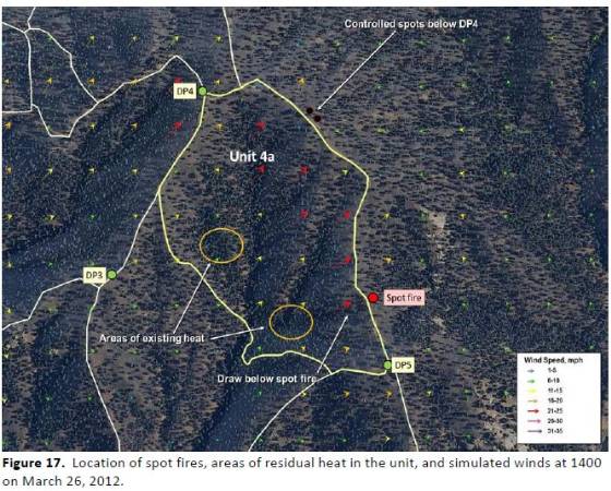
The wind increased and at 1:30 p.m. the ICT4 saw smoke in a different area, on a ridge on the southeast side of the project. Upon driving the ATV, which was out of water, to that location, he saw a 10-foot by 10-foot spot fire burning hot in masticated fuels across but adjacent to the fire line. At 1:47 p.m. he requested more firefighting resources from the Colorado Forest Service, as did the Prescribed Fire Burn Boss at 1:48 p.m. from the Jefferson County Sherriff’s Office. About that time the previously requested engine arrived and the the three firefighters used it to attack the new spot fire, which was 1.5 acres at 1:50 p.m. But it was well established and resistant to control in the increased winds.
More resources arrived after 2:00 p.m, but when the spot fire increased to 7 acres at 2:30 p.m. the fire was declared an escape. The winds pushed the fire down the slope and up the other side of the drainage.

At around 1:00 p.m. three nearby weather stations recorded the following wind speeds: Bailey (7 miles west), 6 mph with gusts to 19; Polhemus (13 miles south), 21 with gusts to 50; and a HOBO station on the prescribed fire site, 15 mph.
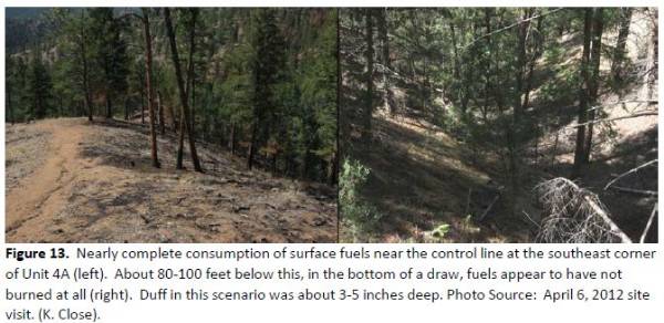
 On the south portion of the prescribed fire in the heavier understory fuels, the consumption during the burn was incomplete to spotty at mid-slope locations. On some lower slopes significant areas appeared not to have burned at all during the prescribed fire due to higher fuel moistures in the cooler locations.
Some of the factors pointed out in the report which potentially contributed to the escape of the prescribed fire:
- Strong winds on March 26.
- Unburned fuels within the burn unit.
- Residual heat remaining within the burn unit.
- Mopping up only 200 feet from the fire line during the wind event.
- The 3-person crew working on the fire on March 26 using a pickup truck instead of a fire engine.
- An inaccurate weather forecast on March 22 (the day of the prescribed fire), which predicted a cooling trend on March 25 and moderate winds on March 25. The wind event for March 26 was first predicted on March 24.
- The unusual method of fire spread consisting of numerous burning embers blowing across the ground “like little burning fleas moving across the ground”.
Recommendations included:
- Improve the inconsistent procedures in the Rocky Mountain Area for managing the fire weather stations (WIMS, RAWS, NFDRS) (Two nearby RAWS stations were incorrectly manually set to “wet flag” during much of March, 2012, which resulted in inaccurate indices. Reference: SAFENET report)
- Colorado State Forest Service (CSFS) should consider using the Energy Release Component (ERC) instead of the Keetch-Byram Drought Index (KBDI) when planning prescribed fires.
- CSFS should consider strengthened procedures for mop-up of prescribed fires in relation to incomplete fuel consumption and residual heat remaining in the burn unit.
The members of the review team, and the roles in which they served, were:
- Bill Bass, Team Leader
- Tom Zimmerman, Planning Section Chief
- Francisco (Frankie) Romero, Fire Behavior Analyst
- Grant (Dave) Hamrick, Operations Section Chief
- Tammy Williams, Public Information Officer
- Jace Ratzlaff, Public Information Officer
- Lester (Dean) Clark, Technical Specialist
- Kelly Close, Fire Behavior Analyst
- Timothy O. Mathewson, Fire Weather and Predictive Services
This is the first time I have noticed that a review team for an incident appeared to be organized under the Incident Command System. It’s about time.
Another remarkable fact about the review — the 152-page report was released only 14 days after the Governor announced that he had asked Bill Bass to lead “…a four–person team to review the prescribed burn…”


where did the weather report that predicted a cooling trend come from?
Fred, the report, on page 59, does not specify the source of the weather forecast that predicted a cooling trend, but many times in the report it says the NWS provided weather forecasts.
Bottom line is, if a control burn escapes your control you are responsible for all damages. In this case the USFS is on the hook. Again the USFS is the worst wildland firefighting agency.
My mistake. I meant the CSFS, not USFS.
Seems to be more and more examples of “mastication” presenting control problems on prescribed fires, as well as being present in several recent prescribed fire escapes.
As someone who has been using mastication for since 2003, I’m not quite sold on its effectiveness of reducing fireline intensity (BTUs), fuel loading/arrangement, nor limiting resistance to control.
Mastication might be a cost effective tool, but is it the right tool?