This video has some good shots from the fireline on the Gladiator Fire in Arizona.
It was shot by Rick Servatius of Bay6 Productions out of Scottsdale, Arizona who has a standing call when needed contract with the Bureau of Land Management to produce videos. The Gladiator fire hired the company under that existing contract to shoot high-definition video at the fire. Ken Frederic of the BLM at Boise told Wildfire Today that he thought the estimated cost was about $4,000 for the five days of shooting, May 17-21, including the post-production tasks. It was Mr. Servatius who uploaded the video to YouTube, not the BLM or the folks at the Gladiator fire.
Here is the description as it appears on YouTube:
This is footage from the fire line at the Gladiator Fire outside of Crown King, AZ. I am a trained fire fighter who carries a camera rather than a shovel and was the only videographer allowed to be on the fire line. I was assigned to the fire for 5 days to shoot footage. At night I would feed this footage to NBC, CBS, ABC, CNN and all the other major networks.
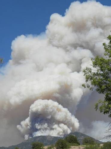
El Capitan Fire, Guadalupe Mountains National Park, NPS photo by Christie La Paz
A 30-person hand crew of Mexican nationals assisted with the suppression of a wildfire in Guadalupe Mountains National Park in western Texas on the New Mexico border (map). The fire started from lightning on May 26 and burned 171 acres before it was contained. Here is an excerpt from an update from New Mexico Fire Information (are you totally confused by all the geographical references so far?):
The Pecos Zone Type III Incident Management Team will transfer management of the El Capitan Fire back to Guadalupe Mountains National Park at Noon today (LaPaz IC). The Pecos Zone Type III Incident Management Team (Northcott IC) took over management of the El Capitan Fire as of 6:00 AM on 5/28/2012.
Summary: The Park remains under Red Flag conditions, with hot, dry weather and high winds. Los Diablos Type 2 Initial Attack Crew, the Truman Engine (Mescalero, NM) and Chihuahua Engine (Ruidoso, NM) will remain at the park, along with the fire crews from Guadalupe Mountains National Park and Carlsbad Caverns National Park, and will continue to monitor the fire for any hot spots and will also be available for initial attack should there be any new fires. They will also continue trimming and removing vegetation to create defensible space around structures to help protect them from any future fires. The fire burned in steep rugged, terrain and crews hiked to the fire. The fire was on the west side of El Capitan Peak, approximately 1 mile east of historic Williams Ranch. The fire is 100% contained with only a few hot spots remaining.
Los Diablos is a crew of more than 30 Mexican national firefighters, from Boquillas and other villages across the Rio Grande from Big Bend National Park, along with National Park Service firefighting personnel. A cooperative effort between the National Park Service, the Department of Homeland Security, the Border Patrol and Mexico, Los Diablos has provide emergency fire services at Big Bend National Park and throughout the United States since 1990. Their name, Los Diablos, which is Spanish for “the Devils,” comes from their promise to work like devils when they are called upon.
The above photo of the El Capitan fire reminded me of some photos I took at the Scotts Spring prescribed fire in 2002 in Scotts Bluff National Monument.
Scotts Spring prescribed fire at Scotts Bluff National Monument, April, 2002. NPS photo by Bill Gabbert Scotts Spring prescribed fire. NPS photo by Bill Gabbert
The Whitewater-Baldy fire grew by another 18,000 acres yesterday to 170,272 acres, becoming the largest in the recorded history of New Mexico, surpassing last year’s Las Conchas fire which blackened 156,593 acres. The Wallow fire last year was the largest in Arizona history. It burned 538,049 acres and destroyed 32 residences.
A person has to wonder. Is this going to be the new norm — frequent record-setting fires, while the number of federal firefighters and air tankers continue to shrink?
U.S. Sen. Ron Wyden has often been critical of how the U.S. Forest Service manages the fleet of large air tankers which has withered by 75 percent from 44 in 2002 to the 11 we have today. We most recently wrote about the shortage of air tankers HERE.
Below is an excerpt from an article in Oregon’s Mail Tribune:
U.S. Sen. Ron Wyden intends to hold the U.S. Forest Service’s feet to the fire to increase its fleet of large air tankers under contract.
“The forest fires are getting bigger and the air tanker fleet is getting smaller,” said Wyden, D-Ore., during a news conference Tuesday morning at the Medford air tanker base. “That has left us with some enormous challenges. We’ve already seen some big fires in Arizona and Colorado.
“Despite the enormity of all this, the agency that is most responsible for fighting them, the Forest Service, has allowed the air tanker fleet to shrink,” he said.
The agency had 44 large air tankers under contract in 2006 but now has only 11, said Wyden, chairman of the Senate Forestry Committee.
“And 10 of those average 50 years of age,” Wyden added. “So we have some of these planes that are getting to the point where they belong in museums rather than the sky.”
The Democrat and other senators in the West, including Lisa Murkowski, R-Alaska, are pushing the agency to modernize the fleet as quickly as possible.
“We now have to deal with an agency back in Washington, D.C., that, in my view, continues to deny the enormity of this problem,” he said.
Police closed a section of the H-3 freeway north of Honolulu on Tuesday when a 350-acre wildfire burned an area behind Kalaheo High School (map) on the north side of the island. The fire reached the ridge above the high school and worked its way down the other side.
Pushed by winds gusting up to 25 mph, it started about 1 p.m. and was mostly contained by 9:30 p.m., coming within 25 yards of some homes.
The fire was fought by eight engines, two water tenders, and two helicopters. Thanks go out to Dietra
We would like to welcome a new supporter of Wildfire Today, The Supply Cache. The company was founded in 1990 by two wildland fire fighters, Jim and Diane Felix. Beginning with a brochure, they later created a web site in 1994, and after outgrowing several business locations, they built and then moved into their own building in 2004, complete with a showroom and 8,000 square feet of warehouse space. They first concentrated on gear for the wildland firefighter, but over the last four years have expanded their inventory to include all risk and USAR equipment. The company says “We are your number one choice for all risk, USAR and wildland fire safety equipment”.
~~~~~~~~~~~
Another new supporter of Wildfire Today is MVP Ambry Equipment. Their MVP hose pack was invented and patented by a fire fighter, and has been field tested by fire fighters. It was designed to be safe, ergonomic, multi-functional, comfortable, and easy to use. The MVP hose pack is safe because firefighters do not have to take their gloves off to deploy hose. It is simple and fast to load and unload because of the “release and attack” design that allows fire fighters to engage the hose pack with one hand, and unroll hose with the other hand in one motion. Additionally, the MVP Hose Pack’s “Deploy and charge” design allows fire fighters to fight fire faster because it allows them to grab the second hose with ease. The Ambry MVP Hose pack also allows fire departments the option to add a third hose. The hose pack has a utility pouch large enough to carry “p-hose” (50’x3/4”), inline tees, hose clamp, gated wyes, and various appliances. If the hose pack is not carrying hose, it can be used to carry firing devices, lunches, waters, other types of hoses, medical supplies, extra fire supplies, or rope. Check out their video which has more information about the hose pack.
A firefighter in Indiana suffered a full cardiac arrest while taking the Work Capacity Test, or Pack Test, in March. Thankfully, as a result of the precautions that were in place, including the presence of an Automatic External Defibrillator (AED), there was a positive outcome.
This AAR was prepared for Drew C. Daily, State Fire Coordinator for the Indiana Department of Natural Resources, Division of Forestry, Fire Control Headquarters by Stephen W. Creech (State Fire Coordinator Retired). Drew is serving as the Operations Section Chief for the Department of Homeland Security following the tornado events that took place on Friday, March 2, 2012. I was present during the medical emergency and Drew requested that I prepare this document.
After Action Review for Medical Emergency during Work Capacity Test
On Friday, March 2, 2012 the IDNR, Division of Forestry held one of their “Annual Refresher” training courses at Prophetstown State Park, Lafayette, Indiana. Due to impending severe weather the Work Capacity Test (WCT) scheduled immediately following the training was moved up to 0900 hours. Weather forecasts indicated that a severe line of strong thunderstorms were scheduled to move through the area at approximately 1030 hours. The course that was selected for the WCT had been accurately measured and marked and was a closed loop course. Participants completed their health screening questionnaire and they were checked by Drew Daily and Darren Bridges and signed. There were no indications that any of the participants suffered from any conditions that would preclude them from participation. The test was started at approximately 0915.
A lead vehicle was provided to guide participants through the course and the Emergency Medical Technician (EMTB) was in this vehicle. A trail vehicle was used to follow the final participant and was operated by one of the Prophetstown employees. The lead vehicle was equipped with an Emergency Warning System (EWS) and VHF mobile radio. The trail vehicle was only equipped with a VHF radio. The medic was also equipped with an 800 MHz portable radio and had contact with the ambulance service. Timers were provided and time splits were given at .5 mile increments. I was personally stationed at the 2.5 mile marker and had cleared all but a couple of participants when the medical emergency occurred.
Approximately 100-meters short of the 2.5 mile marker one of the participants suddenly fell forward and landed face down on the pavement. The medic was approximately 100-meters in front of the victim and was at the victim’s side within seconds. The medic assessed the situation and immediately called for assistance on the radio. The medic advised that the victim was in “full arrest”. Cardio Pulmonary Resuscitation was started immediately and 911 dispatch was notified via the 800 MHz radio. The medic hooked up an Automatic External Defibrillator (AED) and intubated the victim. The AED indicated that a “shock” was advised. Aid givers cleared the patient and the shock was administered. After the shock, CPR was resumed but we could not get a pulse nor was the victim breathing on his own. During the next several minutes (2 – 3 minutes) the AED analyzed the patient several times, but advised that a shock was not recommended. Just as we were getting ready to switch individuals providing CPR the patient seemed to involuntarily convulse a single time. Immediately following this episode the patient started to breathe on his own and a carotid pulse was detected. At this point we could still not get a radial pulse. The approximate time lapse from full cardiac arrest to now was 3 – 4 minutes. Continue reading
Whitewater-Baldy fire, east of Glenwood, NM, 4 pm, May 29. Photo by Andrea Martinez, USFS
Firefighters on the Whitewater-Baldy found themselves conducting firing operations (burnouts or backfires) with the relative humidity as low as two percent and wind gusts up to 26 mph on Tuesday. One of the firing operations on the 152,000-acre blaze was on the northeast side of the fire where firefighters battled extreme fire behavior with spot fires occurring up to one mile ahead of the fire. The Incident Management Team reported that the Probability of Ignition today was 100%. That is, according to weather conditions and fire behavior models, if a firebrand landed in receptive fuels (vegetation) there was a 100 percent probability that it would start a new fire. Firefighters who were directed to ignite burnouts or backfires under those conditions deserve a raise. There were multiple spot fires across Forest Road 141, with one of them growing to 20 acres, but remarkably they were all suppressed by firefighters, engines, a dozer, and two air tankers. Neptune’s Tanker 40, the BAe-146 jet, was one of the air tankers used on the fire today. A big pat on the back goes out to those folks who did great work under interesting conditions.
Other aircraft on the fire included twelve helicopters: three Type 1 (the largest helicopters), four Type 2, and five Type 3.
N144Z, USFS Infrared Aircraft
A U.S. Forest Service fixed wing infrared imaging airplane, N144Z, a Cessna Citation jet, has been mapping the fire during the night for the last several nights providing accurate information about the location of the fire perimeter and the extent and intensity of heat sources across the fire. The data is digitized and transmitted via radio from the aircraft immediately after it is collected and ends up in internet servers on the ground . Then an Infrared Analyst, who can be located anyplace where there is a computer with internet access and ESRI software, interprets the imagery and sends it to the Situation Unit on the fire. When everything works perfectly, they will receive it with enough lead time to produce maps that are used for the morning briefing and the Incident Action Plan.
Flight of N144Z, May 28-29
The map to the right shows the flight of N144Z between 10:38 p.m. May 28, and 1:09 a.m. May 29. It departed from Phoenix, mapped the Gladiator and Whitewater-Baldy fires, then landed at Farmington, New Mexico for fuel. Then it mapped one or two fires in Colorado before heading for home at Ogden, Utah.
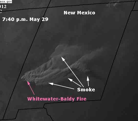
The satellite photo below, taken at 7:40 p.m. today, which we helpfully annotated for your viewing pleasure, shows the smoke that was generated by the extreme fire behavior on the Whitewater-Baldy fire today.
Smoke Whitewater-Baldy fire 7:40 p.m. MDT, May 29, 2012
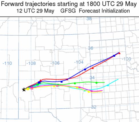
You can compare the actual trajectory of the smoke with the projections created by computer models below. Each line is a 24-hour period, beginning at noon local time. The tic-marks on the lines are six hours apart.
Smoke projection for Whitewater-Baldy fire, May 29, 2012
On Monday afternoon a 9 to 12 mph west wind, gusting up to 22 mph, blew the smoke created by the Whitewater-Baldy fire east across New Mexico, headed toward Texas. The satellite photo above was taken at 7:40 p.m. MDT, May 28.
Smoke map - 742 pm MDT, May 28, 2012
You can compare this with the models from Monday morning which predicted the direction the smoke would take. A higher resolution version of the map below can be found HERE.
Smoke projection for Whitewater-Baldy fire, May 28, 2012
While some of the country has been preoccupied with wildfires in New Mexico, Arizona, Nevada, and California, the Duck Lake fire in the Upper Peninsula of Michigan has been ripping through 20,053 acres and 95 structures, including, according to the Michigan Department of Natural Resources (DNR):
34 homes/cabins
22 garages
20 sheds/outbuildings
17 campers
1 store
1 motel
Six miles of the fire perimeter are along the shore of Lake Superior and the fire stretches south 11 miles to Highway 123.
The photo shows a good wet line on the north end of the Duck Lake Fire, May 25, 2012. Michigan DNR photo
Working to suppress the fire are 214 personnel, 27 engines, 13 dozers, 2 Minnesota DNR air tankers, and 4 Michigan Army National Guard Blackhawk helicopters. (UPDATE, May 29: in addition there is a Type 1 helicopter, a Skycrane, helitanker 718, which can carry a 25,000 pay load.)
An evacuation order is in effect for some homes in the Pike Lake area.
There are currently 40 miles of fire line. Of that, 6 miles is Lake Superior shoreline, 13 miles is completed line, and 21 miles is uncontained. Access is very difficult with few roads.
The entire east side of the fire, from Little Lake Harbor south, is active and with expected westerly/southwesterly winds on Monday, extreme fire conditions persist, according to the DNR.