Wildfire morning briefing, September 29, 2012

Map of wildfires detected by satellites, September 29, 2012

Men who started Wallow fire may owe more than $3 million

The two cousins who started the 2011 Wallow Fire may be on the hook to pay over $3 million. Caleb and David Malboeuf are on probation following last month’s sentencing for leaving a campfire unattended. During restitution hearings this week attorneys for both sides agreed that $3 million is appropriate, but they are still haggling over an additional $500,000, with the defendants’ attorney saying documentation is incomplete for those funds.

The Wallow Fire, which burned from eastern Arizona into New Mexico, became the largest fire in the history of Arizona. It burned over half a million acres and destroyed 32 homes and 4 commercial structures. At least $79 million was spent to suppress the fire.

Turn over federal lands to the states?

There is a growing chorus among certain political groups and at least one state to give away millions of acres of federal land. For example, the Governor of Utah signed a bill that demands that the federal government hand over almost 30 million acres to the state. Other states are looking to follow Utah’s lead, and a candidate for President, Mitt Romney, is on board. Timothy Egan has a thoughtful article in the New York Times about this expanding threat.

If the national parks, forests, and BLM lands are given away or sold, the 16,000 wildland firefighters that now work for the Department of Interior and the US Forest Service, if they still have jobs, may find themselves working for a state, or a private company such as British Petroleum, Weyerhaeuser, or Union Pacific Coal Company.

Waldo Canyon fire slowed air travel into Colorado Springs

While the Waldo Canyon Fire was burning in and near Colorado Springs, three of the four airlines serving the city reported a decline in passenger numbers. The fire started June 23, killed two people, and destroyed about 346 homes.

Fire activity in the Northwest and northern Rocky Mountains

Usually by early to mid-September the fire season in the northern Rocky Mountains and the Northwest is seriously winding down, but firefighters in those areas are still busy. It is very unusual this late in the year, but air tankers are still stationed at Billings, Montana.

Below is a map showing heat detected today by satellites on wildfires in Montana, Idaho, Washington, Wyoming and Oregon. Click on the image to see a larger version.

Map of wildfires detected by satellites, September 29, 2012

Interesting headlines

I like this headline in Utah’s Park Record:

Fire prescribed for 570 acres near Wyoming border

Here is another one, this time from the Ramona Sentinel in California:

Cal Fire crushes grass fire near airport


Thanks go out to Chris and Dick

Happy National Coffee Day

Wildfire Today coffee mug

So what are you doing to celebrate National Coffee Day?

Wildfire Today coffee mug

Yep, that’s what today is. It’s a real thing. So real, in fact, that some businesses are actually giving away coffee on this very special day — for example Krispy Kreme, McDonalds, Caribou Coffee, and Dunn Brothers. Not all chain locations are participating, so ask first.

And another reason to enjoy your cup of coffee today; researchers this year found that java drinkers who average several cups per day had the lowest risk of death during the study.

I’m going to enjoy this cup and then watch some football. What are you doing today?


Man gets death sentence for starting the Old fire in 2003

Rickie Lee Fowler
Rickie Lee Fowler

A jury has recommended that Rickie Lee Fowler be sentenced to death for starting the 2003 Old fire that destroyed 1,003 homes, burned 91,000 acres, and led to five deaths. He was convicted on August 15 of two arson charges and of murdering the five people who died of heart attacks after their homes burned or while they evacuated during the fire near San Bernardino, California.

The judge in the case has the legal authority to reduce the death sentence to life in prison, but that rarely occurs in California.

In the trial, the State employed the same principle used when prosecutors in neighboring Riverside County won a death penalty conviction against Raymond Lee Oyler, an auto mechanic who set the 2006 Esperanza wildfire that killed five federal firefighters. Oyler is believed to be the first person in the U.S. to be convicted of first-degree murder and sentenced to death in a wildland arson case.

Before the trial Mr. Fowler said he and three men in a van had intended to rob John Aylward, a person he identified as his godfather, but realized they were too drunk or stoned to pull it off. Instead, they decided to start a fire, as one person testified before a grand jury, “to burn John’s house down”.

In an interview with investigators, Mr. Fowler said he struck the flare and threw it into the vegetation, but corrected himself and said one of the other men in the van struck the flare. In a later interview, he said he intended to strike and throw the flare, but Martin Valdez Jr. took it from him, struck it, and threw it into the brush.

While in prison before the trial, Mr. Fowler was convicted of sodomizing another jail inmate and sentenced to three 25-years-to-life prison terms.

Morning briefing, September 28, 2012

Nebraska prescribed fire

Junior firefighter killed while responding to wildfire 

A 17-year old junior firefighter for the Dagsboro Volunteer Fire Department in Delaware was killed while en route to the fire station to respond to a wildfire. According to WBOC, Justin Townsend was a passenger in a vehicle driven by an 18-year old boy on September 27 when due to excessive speed the driver lost control on a curve causing the vehicle to strike a utility pole. Mr. Townsend died at the scene. The driver was treated at a hospital and released.

We extend our sincere condolences to Mr. Townsend’s family and the members of the Dagsboro Volunteer Fire Department.

TNC studies use of prescribed fire to remove red-cedar 

The Nature Conservancy has released a study they conducted on the Niobrara Valley Preserve in Nebraska, looking at red-cedar, an invasive species that can reduce the productivity of grazing land. The trees occupy grassland areas shading out light, falling foliage covers the grasses, and the trees consume significant amounts of water, leading to dryer conditions for grass. Red-cedar also burns intensely, making wildfires more difficult to control.

Nebraska prescribed fire
Prescribed fire in Nebraska to help remove invasive red-cedar. Photo credit: The Nature Conservancy

The study looked at two methods used to remove red-cedar on the property — mechanical removal and prescribed fire. Fire can be useful for removing red-cedar until the trees become large. After that, only mechanical methods are effective, which may include cutting the trees, and then 1) chipping, 2) piling and burning, or 3) scattering them to be burned in a prescribed fire later.

Here are some excerpts from the report.

Red-cedar, a tree that reproduces by seed only, can be destroyed by fire if its growth points at the tip of the twigs are exposed to high temperatures. Cedar infestation will proceed steadily without intervention, and the periodic use of prescribed burning may be a more effective approach compared to periodic mechanical removal. Mechanical removal actually can contribute to spreading the seeds. Importantly, when applied early, burning is a significantly less costly method to eliminate young trees and to prevent re-infestation.

and…

Of more interest to ranchers, in areas where cedar was removed, the desirable plant species for grazers were on average 34% of groundcover compared to 12% in non-cleared areas (+22%) and the undesirable plant species were 13% in cleared areas versus 47% in non-cleared areas (-34%) but all save 3% of the difference in undesirable plant species is from cedar clearing.

Warmer temperatures in California may be leading to more wildfires

The LA Times has an article about how hotter temperatures in California along with “incredibly dry conditions” have resulted in a higher number of wildfires, especially in the northern part of the state. The traditional busiest part of the fire season in southern California is just beginning, when lower live fuel moistures combined with Santa Ana winds can result in very large fires.

Photos of fire in Columbia River Gorge

A wildfire in the Columbia River Gorge near Hood River, Oregon provided Richard Porter with an opportunity to capture some interesting nighttime images of the fire reflected in the waters of the Columbia River. Check them out HERE. Below is a sample.

Fire in Columbia River Gorge
Fire in Columbia River Gorge. Photo by Richard Porter

San Diego County develops disaster preparedness app for the public

San Diego County app, emergency news

The County of San Diego has developed an app that can provide the public with information about ongoing emergency incidents that may affect residents and visitors. Available for Android and Apple smart phones and devices, the “SD Emergency” app has breaking news about incidents, maps of incidents, and the locations of shelters. It also has disaster preparedness information and interactive checklists to help you to create an emergency plan and build an emergency supplies kit.

If you register the app and provide some contact information, it will send to your device push notifications of new emergencies and updates.

Every large city should have an app like this. It was released a week ago, and the best feature is…. it is free.

Six single engine air tankers ready for fires in South Dakota

Air Tanker 466 at Hot Springs
Air Tanker 466, a Dromader, at Hot Springs, SD, March 14, 2012. Photo by Bill Gabbert

In what is unprecedented in the state, six Single Engine Air Tankers (SEATs) are staged and available to help to fight wildfires in South Dakota this week. The aircraft are positioned at  Pierre, Mobridge, Valentine, Hot Springs and two in Lemmon.

Part of the reason for the surge in the numbers of air tankers is the opening of pronghorn antelope season on Saturday.

There have been quite a few fires in western South Dakota this year and the SEATs have been busy.

Incident Management Team using iPads on Sawtooth Fire

Sawtooth Fire
Sawtooth Fire
Sawtooth Fire, Inciweb photo

Greg Poncin’s Type 1 Incident Management Team is using iPads as they manage the Sawtooth Fire near Hamilton, Montana. A member of the team developed an app that can assist in collecting and distributing information on a near real time basis wirelessly using a 3G cell phone system. The team is using them to share maps, documents, photos, and videos.

An article at KAJ18 about the system does not say, but I imagine they are putting the Incident Action Plan on the devices as well. iPads may not be very practical to carry on the fireline, but if it is compatible with an iPhone, firefighters in a spike camp may in the future be submitting their time to the finance section on a hand-held wireless device.

If the team does not have a wireless hot spot at the Incident Command Post, the system would be dependent on 3G cell phone service, which is not always easy to find at the scene of a large wildland fire.

A video at KAJ18 features Incident Commander Poncin describing the innovation.

The Sawtooth fire, according to the information on InciWeb, has burned 5,882 acres and is 45 percent contained.

UPDATE at 10:40 a.m. MT, September 28, 2012:

Kelly reports to us that a helicopter pilot friend told her that on the Sawtooth fire the Helicopter Managers were getting the Incident Action Plans (IAP) wirelessly. On the Halstead fire the pilot obtained copies of maps by using a smart phone or iPad to scan a QR code (similar to a bar code) on the front of the IAP.

The possibilities for this kind of technology are endless.

What new technologies have you seen recently on wildfires? Or, what new technologies have the potential to be implemented on fires which could enhance efficiency, reduce costs, or help to provide a safer working environment for firefighters?

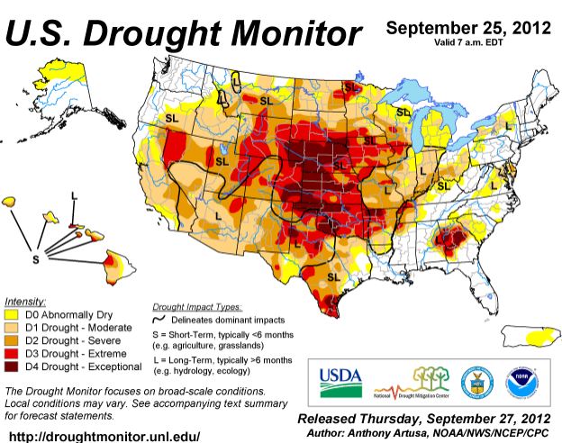
Updated drought map

Drought Monitor Map, September 25, 2012

Drought Monitor Map, September 25, 2012An updated drought monitor map was released today, current as of September 25, 2012. It is similar to the map we posted on September 8, but has a few areas moving into the next higher level of dryness. As before, most of the United States is in some form of drought.

Squirrel causes vehicle fire

Vehicle fire south of Wind Cave National Park
Vehicle fire south of Wind Cave National Park, 1:15 p.m. MT, September 26, 2012. Wildfire Today photo by Bill Gabbert

Wednesday afternoon an older couple was driving their Dodge pickup truck on US Highway 385 just south of Wind Cave National Park in South Dakota when they smelled smoke. The driver told us that it smelled like a forest fire but they could not see any nearby — until the interior of the truck filled with smoke. They pulled over and called 911 on their cell phone and then stood on the side of the road several hundred feet away with their two dogs as the truck burned, waiting for what they thought was the inevitable explosion — just like they have seen so many times in movies.

Vehicle fire south of Wind Cave National Park

When they received the dispatch to the fire the engine crew from Wind Cave was only about four miles away doing some training. Already wearing their Nomex shirts, they responded in Engine 628 (the white truck) and saw that the burning vehicle was on the side of the road parked at a driveway, which provided more clearance than if the truck had stopped anywhere else. With the strong wind that was blowing, one burning ember in the grass alongside the road and the fire would have been over the hill quickly. The National Park Service engine crew quickly knocked down the fire, keeping it from spreading into the vegetation, and then turned it over to firefighters from Hot Springs when they arrived from their station about 6 miles away.

Congratulations to the Wind Cave crew for preventing what could have become a large vegetation fire. The weather at the Elk Mountain weather station a few miles away recorded a 10 mph wind with gusts up to 22 at the time of the fire. Darren Clabo, a fire meteorologist for the state of South Dakota, sent out this tweet earlier today:

Extreme Fire Danger for many West River counties today. Gusty southeast winds with RHs falling below 20%


Vehicle fire south of Wind Cave National Park

The occupants told us that after they pulled over they saw pine cones dropping out of the engine compartment as the truck burned. They figured that while they had been camping, a squirrel had designated their truck as a storage facility for its’ winter food supply. The pine cones must have been close to an exhaust pipe which caused them to ignite.

After I downloaded these images I noticed some pine cones in the picture above. Below is an enlargement of the area below the truck’s engine, with arrows pointing out some of the pine cones that were still recognizable.

Pine cones at vehicle fire south of Wind Cave National Park
Pine cones at vehicle fire south of Wind Cave National Park (click to enlarge)

We are adding this to our articles that are tagged “animal arson” — the 10th in the series — so far.

Time lapse video of Dugan Fire in Montana

Dugan Fire

I like time lapse videos of wildfires. This one of the Dugan Fire near Ekalaka in southeast Montana (map) not only shows the fire itself, but also includes some dozers working at what appears to be 500 miles an hour. It begins with some still images — the time lapse starts at 0:37.

(video no longer available)

The Dugan Fire burned 10,675 acres and is contained, according to InciWeb. Below is another photo of the fire.

Dugan Fire
Dugan Fire, InciWeb photo