(UPDATE at 9:35 a.m. MT, June 14, 2013)
All evacuations were lifted and Highway 50 reopened last night at 8 p.m. Cooler temperatures, along with higher relative humidity and light winds kept fire activity on Thursday to a minimum. The fire listed at 3,162 acres and 40 percent containment.
Predicted weather for the next several days calls for continued cooler temperatures and higher relative humidity. On Friday, fire crews will continue to construct, secure and mop up containment lines around the fire perimeter.
****
(UPDATE at 5:58 p.m. MT, June 13, 2013)

Below is an update from the Royal Gorge Fire’s Incident Management Team:
Yesterday the fire was active along the western flank. Fire managers felt that good progress was made along the eastern flank, and as a result the fire is now estimated to be 20 percent contained. Areas of the fire are burning in fuels that are 20 to 30 percent beetle-killed trees.
Our goal is to strengthen our containment lines and to keep this fire south of Highway 50, said Dan Dallas, Rocky Mountain Incident Management Team 2 Incident Commander.
Fire fighters will continue constructing line along the fires perimeter, and continue structure protection south of U.S. HWY 50. Approximately 136 people are on the fire with more resources scheduled to arrive throughout the day.
Below are some notes from a 4 p.m. briefing today about the privately-owned park at the Gorge:
- It began with a prayer.
- “The national treasure, the bridge, is intact, we drove across it today”.
- 48 of 52 park structures were destroyed in the fire.
- All of the seasonal jobs are suspended.
- They will rebuild in a year, and hope to be open on a limited basis in months
****
(UPDATE at 8:50 p.m. MT, June 12, 2013)
During a press briefing that just concluded, the following information was given:
- Fire behavior throughout the day was active with visible torching, spotting and running in heavy fuels.
- The infrared mapping flight requested for last night did not occur, but the estimated size of the fire is 3,000 acres, with 20 percent containment.
- 20 structures burned in the fire. A number of buildings related to tourist activities, the bridge, and the gorge were destroyed. No homes have burned.
- The bridge over the Gorge is intact, but 33 planks were damaged.
- Firefighters are concerned about a Red Flag Warning in the weather forecast for Thursday, which predicts gusty winds, low humidity, and dry fuels. With that, the fire behavior Thursday may be similar to the rapid fire spread observed Tuesday.
- Rocky Mountain Type 2 Incident Management Team B, with Incident Commander Dan Dallas, has arrived, been briefed, and will assume command of the fire at 6 a.m. Thursday.
- Over 200 personnel are assigned to the fire.
- Most of the firefighters coming off the fireline tonight, according to the Information Officer on the Type 3 IMTeam, have been working since the fire was reported on Tuesday and have not slept since then.
A larger version of the map below can be found HERE.

****
(UPDATE at 4:27 p.m. MT, June 12, 2013)
KKTV, the Colorado Springs station that is providing excellent live stream coverage of the fires, just reported that the Royal Gorge Fire has burned 20 structures and 3,000 acres, and it is 20 percent contained.
****
(UPDATE at 2:12 p.m. MT, June 12, 2013)
As we reported yesterday, the two Modular Airborne FireFighting Systems (MAFFS) C-130 air tankers at Peterson Air Force Base in Colorado Springs have been activated for this surge in wildfire occurrence and were seen in the air near the Black Forest Fire an hour or two ago. More information about the MAFFS activation and how they were used in Colorado in 2012 is at Fire Aviation.
Below is a map of the Royal Gorge Fire provided by the National Weather Service, which credits the National Interagency Fire Center for the data.

****
(Originally published at 8:41 a.m. MT, June 12, 2013; updated at 11:18 a.m. MT, June 12, 2013)
Strong winds pushed the Royal Gorge Fire through an estimated 3,800 acres near Canon City, southwest of Colorado Springs Tuesday. The fire started south of the Arkansas River and spotted across, burning on BLM, state, and private lands requiring mandatory evacuations in the area. Denver’s ABC7 has created a map showing the evacuation zone for the Royal Gorge Fire.

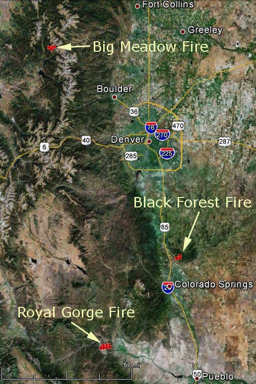
The map of the Royal Gorge Fire above shows the approximate location of heat detected by a satellite at 10:25 p.m. MT, June 11, 2013.
A Type 2 Incident Management Team has been ordered for the fire.
A DC-10 that had been working fires in New Mexico made some retardant drops on the Royal Gorge fire Tuesday. However, 30+ mph winds at Grand Junction on Tuesday made it impossible for two Single Engine Air Tankers to take off. Strong winds at the fire would have made it difficult for pilots to hit their targets since it may have been blown off target.

Three structures have been confirmed as destroyed.
HERE is a link to a web cam view of the area.
The Canon City Daily Record reports a prison, the Colorado Territorial Facility, evacuated 881 inmates to the vacant CSP II facility Tuesday night because of the Royal Gorge Fire.
The map below shows the location of the three large fires burning in Colorado.


