(UPDATED at 12:13 p.m. PDT, May 16, 2014)
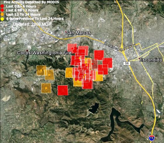
CAL FIRE reports that that as of early Friday morning the Cocos Fire in San Marcos has burned 3,018 acres and is 10 percent contained. See the link in the previous update for a link to a satellite map of the fire.
The weather in southern California is expected to be 10 to 20 degrees cooler than it has been, which should give firefighters a chance to make some headway on the fires.
Evacuation notices have been lifted for thousands of residents in the San Marcos area.
Since the Cocos Fire started on Wednesday, 76,000 alerts have been sent to residents, via texts, emails and phone calls. The total does not translate to 76,000 people being evacuated because many residents receive the alerts by all three forms of communication.
****
(UPDATED at 8:54 a.m. PDT, May 16, 2014)
A new satellite map is available for the Cocos Fire. It showed little additional spread of the fire overnight.
****
(UPDATED at 7:18 p.m. PDT, May 15, 2014)

The Cocos Fire, formerly known as the Washingtonia Fire, has been very active today, challenging firefighters who are trying to protect structures in remote areas surrounded by southern California chaparral. CAL Fire reports the fire has burned 1,200 acres and is 5 percent contained.
From the LA Times at 6:54 p.m. PDT, May 15:
Authorities in San Diego County issued hundreds of new mandatory evacuation orders Thursday afternoon as a wildfire in the San Marcos area grew to 1,200 acres and was spreading east toward Escondido.
Escondido residents in neighborhoods north and west of West Valley Parkway between Via Rancho Parkway and Highway 78 were ordered to leave their homes as two flanks of the Cocos wildfire raged along parched hillsides overlooking the city, officials said.

Nearby weather stations measured the temperature at close to 100 degrees early in the afternoon.
Various reports from County and fire officials today say that 12 or 22 military helicopters are available if needed. Some of them have been dropping on the Cocos Fire today.
****
(Originally published at 6:05 a.m. PDT, May 15, 2014)

The fire in San Marcos, California that was first called Washingtonia and later changed to Cocos, is the only fire in San Diego County that was still showing large amounts of heat when the satellite passed over at 3:20 a.m. PDT Thursday. That does not mean the other fires are out, it could mean firefighters have at least temporarily slowed the spread to the point where they are not creating enough heat to be detected by the satellite hundreds of miles overhead.
Cocos Fire update- 700 acres 0% containment. Confirmed 3 homes destroyed, 1 structure damaged. Fire is still active and moving to the south.
— CAL FIRE SAN DIEGO (@CALFIRESANDIEGO) May 15, 2014
The map of the fire above shows the location of the Poinsettia, Cocos, and Bernardo Fires. The Cocos fire, according to CAL FIRE at 3:41 a.m. Thursday, has burned about 700 acres and three homes. The campus of Cal State San Marcos was evacuated Wednesday, and the City of San Marcos reported that all neighborhoods south of San Marcos Blvd, including Lake San Marcos, also evacuated Wednesday afternoon. By 10 p.m. 600 more evacuation notices were issued for the Elfin Forest, Indian Road, Crestwind Road, Wilgen Drive and De Loma Drive areas, according to county officials. Channel 8 said a total of about 21,000 residents have been evacuated. CAL FIRE reported that three homes have burned. San Diego County announced more evacuations at 4:21 a.m. on Thursday:
New evacuations in Cocos fire in San Marcos. Incl. Questhaven, Harmony Grove, parts of Elfin Forest http://t.co/7n8ptqVi1G — SanDiegoCounty (@SanDiegoCounty) May 15, 2014
San Diego County is maintaining a map showing the areas that are under evacuation orders.
We have a summary of eight fires that were burning Wednesday in San Diego County.
