The 2015 large air tanker lineup for US Forest Service


Air Tankers June 2015

All 13 of the large and very large fixed wing air tankers that have been on standard exclusive use contracts since last year have started their Mandatory Availability Period and are on duty.  The last two, MD-87s operated by Aero Air, began in the first half of June and should end in mid-December. All 13 air tankers except for three are scheduled to work 160 days. The exceptions are two P2Vs, on duty for 180 days each, and another P2V which is planned for 140 days. All of the P2Vs are operated by Neptune Aviation.

The handful of air tankers that were brought on as “additional equipment” on contracts in 2014 will not be working under the same arrangement this year — the “additional equipment” concept is no longer being used by the Department of Agriculture. Those extra aircraft will have to be employed under new contracts for each air tanker or come on under the Call When Needed contracts that were awarded earlier this month.

The U.S. Forest Service is attempting to issue exclusive use contracts for “up to seven” more next-generation air tankers. The agency hoped to have them working by May 30, but the process came to a screeching halt a couple of months ago.

Two companies, Coulson Aviation and Erickson Aero Tanker, filed protests about this latest round of potential contracts. The protests were lodged with the U.S. Government Accountability Office, the agency with the responsibility of deciding whether the protests have merit, which they are required to do by July 9 for Coulson’s protest and July 17 for Erickson’s. Both companies later amended their original complaints, which complicates the procedure for the GAO, so it is unlikely that anything will be decided much before those mid-July due dates.

Tanker 118 HC-130H
The Coast Guard HC-130H that will become Tanker 118. Undated photo by the Coast Guard.

A 14th air tanker is expected to be ready to fight fire by the end of July, according to Jennifer Jones, a spokesperson for the U.S. Forest Service. That aircraft is Tanker 118, one of the seven HC-130Hs owned by the Coast Guard that are in the process of undergoing major maintenance and conversion to air tankers.

T-118, Government Owned/Contractor Operated, has been at McClellan Airport for a couple of weeks and is being used, with a lead plane, for training flight crews. It does not have a conventional gravity-based retardant tank, yet, but will be using one of the eight Modular Airborne FireFighting Systems (MAFFS) that use compressed air to force 3,000 gallons of retardant out of the internal slip-in tank. Eventually it and the other six HC-130Hs will have a gravity tank, using the same basic concept employed by all of the Contractor Owned/Contractor Operated large air tankers.

The hourly and daily rates for the HC-130H are estimated at this early stage of deployment of the aircraft, Jones told us.

“The rates are expected to decrease after the program is stood up and the expenses can be spread across multiple aircraft”, she said. “Costs incorporate many aspects of the program, including hangar facilities, U.S. Coast Guard engineering and airworthiness support, maintenance and pilot contracts, and MAFFS maintenance.”

Tanker 118 does not have a tail number yet, since it is still owned by the Coast Guard. Later, possibly this year, it will depart McClellan to finish the conversion to an air tanker, getting the gravity retardant tank and a new paint job– after which the title can be transferred to the USFS.

A second HC-130H will arrive at McClellan in a few months and this year will be used only for training. The other five HC-130Hs will gradually enter the USFS air tanker fleet over the next several years.

$50 million in claims over escaped prescribed fire reportedly denied

Pautre Fire origin
USFS photo from the report on the escaped prescribed fire, the Pautre Fire, in North Dakota and South Dakota.

The Associated Press is reporting that the Department of Agriculture, in a letter signed by Department Secretary Tom Vilsack, is denying $50 million in claims filed by sixteen ranchers and landowners over a prescribed fire that escaped and burned 10,679 acres in North Dakota and South Dakota.

The “Pasture 3B” prescribed fire was planned to be 210 acres on the Dakota Prairie National Grasslands, but strong winds on April 3, 2013 caused by the predicted passage of a cold front pushed the fire across a mowed fire line into tall grass and ultimately burned 10,679 acres, (3,519 acres federal and 7,160 acres private). The wildfire, named Pautre Fire, was stopped at 11 p.m. that night.

In explaining the denial, Secretary Vilsack said the Forest Service relied on forecasts from the National Weather Service in Rapid City, South Dakota, that ultimately proved inaccurate.

In February, 2014 the US Forest Service released a report about the fire, called a “Facilitated Learning Analysis. The issues listed by the document included:

  • Improved weather forecasts are needed.
  • Consider additional research on methods to predict effects of drought on fire behavior in grass fuel models.
  • The nearest remote automated weather station (RAWS) is more than 90 miles away.
  • The project was conducted at the critical edge of the prescription.
  • Consider gaming out worst case scenario “what ifs” during the planning process, and discuss with participants during the on-site briefing.
  • There were problems with radio communications [note from Bill: I don’t remember EVER seeing a report like this that did not cite radio communications as being an issue].

Yarnell Hill Fire families settle lawsuit

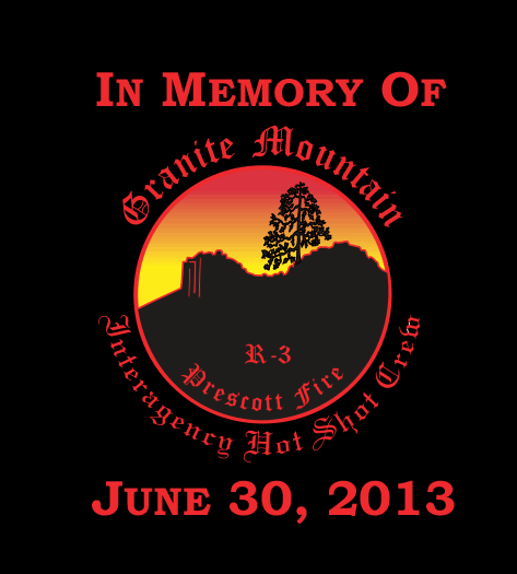
memory yarnell hill fireSome of the families of the deceased Granite Mountain Hotshots settled their lawsuit the day before the second anniversary of that tragic day. On June 29 the families of 12 of the crewmembers settled a wrongful-death suit for $50,000 each along with some reforms they hope will help to prevent similar catastrophes. Two years ago today 19 members of the crew were killed on the Yarnell Hill Fire south of Prescott, Arizona when they were entrapped and overrun by a wildfire that later burned into the community of Yarnell, destroying 127 structures.

The resolution was announced Monday at a news conference. In addition to the $50,000 for each of 12 families, the state of Arizona will give $10,000 to each of the seven families that did not participate in the lawsuit.

Granite Mountain
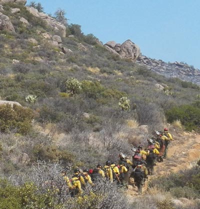
Granite Mountain Hotshots hiking to their assignment, June 30, 2013. Photo by Joy Collura.

The settlement also stipulates that the state will make a “good faith effort” to implement reforms suggested by the families of the hotshots, but their implementation is not binding and will be up to the sole discretion of the agency director.

  • The state Forestry Division will ask the National Wildfire Coordinating Group to do a question-and-answer session and a staff ride so that firefighters can better understand what happened that day two years ago.
  • The state will recommend additional training for initial attack of new fires.
  • State Forestry will volunteer to participate as a testing site for new wildfire technology, including radios and GPS tracking devices. One of the issues on the Yarnell Hill Fire was that it is possible that few if any other firefighters on the fire were aware of the location of the crew and the danger that they were in.

The $220 million lawsuit was settled for a total of $670,000, plus the “good faith” concessions.

The agreement occurred without any testimony from Brendan McDonough, the only survivor from the 20-person crew. Attorneys for State Forestry repeatedly sought his information about the fire under oath, but a deposition never occurred. Mr. McDonough has said he suffers from post-traumatic stress disorder since the fire.

Brendan McDonough
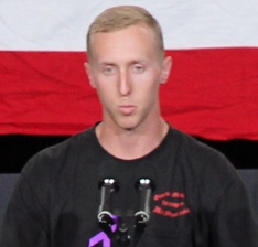
Brendan McDonough. Photo by Bill Gabbert.

At the time of the fatalities he was in a different location serving as a lookout, providing intelligence to the crew about the location of the fire. The largest remaining question about the Yarnell Hill Fire is why the 19 firefighters left the safety of a previously burned area and hiked through unburned brush where they were overrun by the fire. Nothing in the two official reports shed any light on this important question.

An article in the April 3 edition of the Arizona Republic includes information that was previously unknown to the public. The newspaper reported that Mr. McDonough overheard a radio conversation between the Division Supervisor, Eric Marsh, and Jesse Steed who was temporarily serving as the Hotshots’ crew boss. Supposedly Mr. Marsh who normally was the Crew Boss or Superintendent of the crew, told Mr. Steed to have the crew leave the safety zone and to join him at a ranch.

The question of why the crew was in that location may never be answered, unless Mr. McDonough elaborates on the issue in the book he is working on. In April it was announced that he signed a deal with New York Times bestselling author Stephan Talty to write “the untold story from the lone survivor of the Yarnell Hill Fire”.

Below is an excerpt from a June 29, 2015 article in the Arizona Republic:

Attorney Pat McGroder said the goal of the 12 families was to prevent future tragedies and improve wildland-firefighting safety. He emphasized they were not out to make money and said the minimal compensation and promised firefighting improvements underscore that point.

McGroder had strong words for the federal government, which banned the Blue Ridge Hotshots from talking publicly about what they may have heard over the radios that day.

“At sometime, Mr. McDonough may or may not choose to publicly describe what he saw, what he heard that day,” McGroder said. “The idea that the federal government is withholding information … speaks to the lack of understanding and empathy that they should have for these families. So, we would publicly call for … the national Forest Service to let their people talk.”

Yarnell Hill Fire — two years ago today

In memory Yarnell Hill

It was two years ago today, June 30, 2013, that 19 members of the Granite Mountain Hotshots died on the Yarnell Hill Fire south of Prescott, Arizona. May they rest in peace. Our hearts go out to their families and friends.

1.7 million acres burning in Alaska wildfires

Jumper arriving at Kobe Fire
Smokejumper arriving at the Kobe Fire, six miles NE of Mile Post 275 on the Parks Highway in Alaska. Photo by Zoey Taylor.

There are 285 active fires burning in Alaska that have charred 1.7 million acres, according to the Alaska Interagency Coordination Center. Of those 285 fires, 41 are staffed and the other 244 are being monitored.

The National Interagency Coordination Center reports that the firefighting resources assigned to fires in Alaska include: 106 hand crews, 33 engines, and 29 helicopters.

Alaska top 10 fires
These are the top 10 fires, by size, currently reported by InciWeb in Alaska.

A fun fact — a Bureau of Land Management Type 3 helicopter (H-173BH) recently completed a four-day trip to an assignment in Alaska. It took off from Rifle, Colorado on June 23 and arrived in Fairbanks June 26. The BLM sent other Type 3 helicopters, one each, from Montana, Wyoming and Utah. Two Forest Service Type 2 helicopters were also recently dispatched from the lower 48 states. In addition, a Type 1 CWN helicopter, Croman 701, an S-61, was also sent to Alaska.

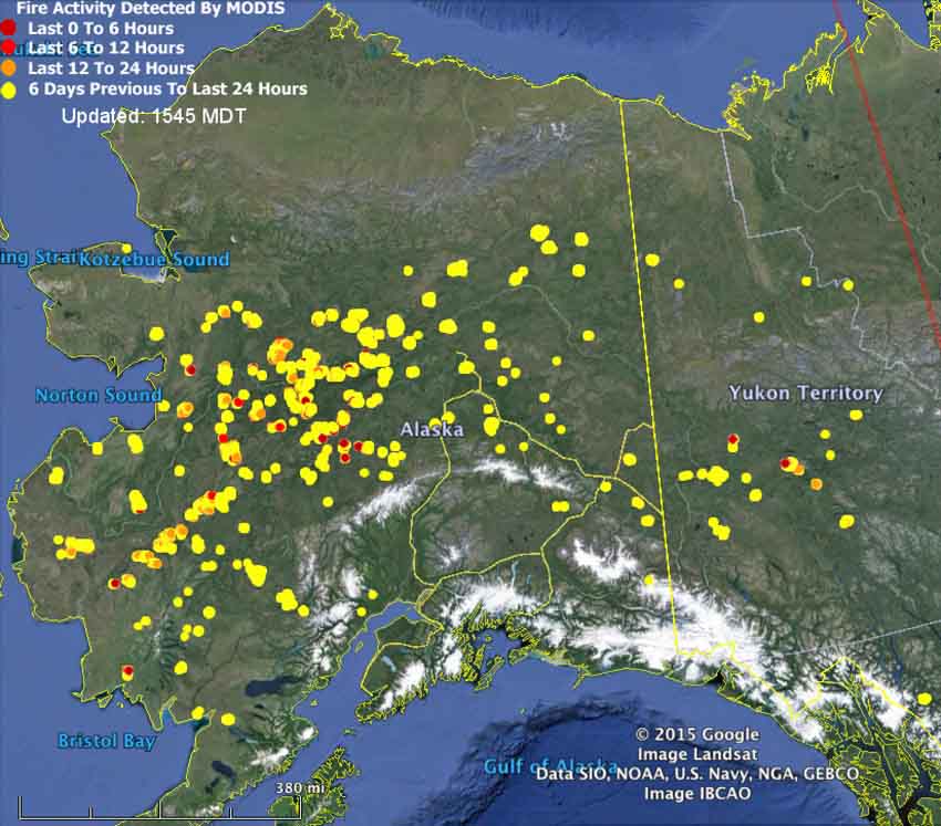
Map of Alaska Fires June 29, 2015
Map of Alaska Fires, at 3:56 p.m. MT, June 29, 2015.


Whitefish Fire
Whitefish Fire, 8 miles south of Kalskag, June 17, 2015.

Homes burn in Wenatchee, Washington wildfire

(UPDATED at 7:32 p.m. PT, July 1, 2015)

Sleepy Hollow Fire map
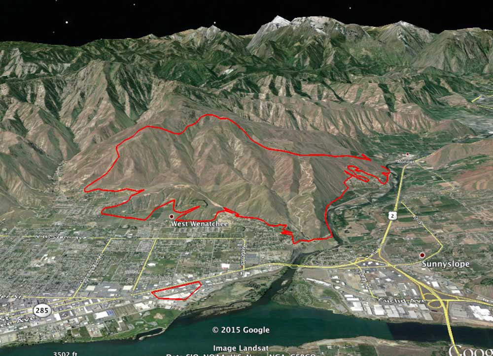
3-D map of the Sleepy Hollow Fire, looking west, 1 a.m. PT, June 30, 2015. Note the spot fire near the river that is 1.2 miles east of the main fire. (click to enlarge)

The map above is a 3-D map of the Sleepy Hollow Fire in central Washington, looking west, produced after a mapping flight at 1 a.m. PT, July 1.

One interesting thing is the spot fire that caused several businesses to burn near the river. It was 1.2 miles away from the main fire. This is not unheard of, for a burning ember to travel that far and ignite a new fire. It has happened over much greater distances.

A recent example was on the King Fire in northern California in 2014 — a spot fire occurred 2 miles in front of the main fire.


****

(UPDATED at 10:58 a.m. PT, June 30, 2015)

The Sleepy Hollow Fire 95 air miles east of Seattle has been mapped at 2,995 acres. The incident commander, according to @jwhittenbergK5, confirms that 24 residences burned.

Heavy rain Sunday evening stopped the spread of the fire, however the industrial facilities continued to burn.

****

(UPDATED at 9:38 p.m. PT, June 29, 2015)

Fire officials are reported at 3:35 p.m. on Monday that the Sleepy Hollow Fire that spread into Wenatchee, Washington burned 24 to 28 residences, and that a more accurate count will be available when fire crews are able to access the entire burned area. They are estimating the size at 4,000 acres.

Wenatchee is in central Washington, 95 air miles miles east of Seattle.

Approximately four businesses also burned, some of which were about a mile from the main fire. The suspicion is that burning embers landed in some bales of cardboard that were being recycled and that fire spread into the industrial structures.

****

(UPDATED at 4:03 PT, June 29, 2015)

The Wenatchee World has a gallery of photos showing the neighborhoods that burned.

Rain on Monday, heavy in some areas, will make the job of firefighters much easier. The precipitation even caused a mud slide that closed Highway 2 near the mouth of Pine Canyon shortly after 3 p.m.

****

(UPDATED at 11:42 a.m. PT, June 29, 2015)

As you will hear in the video above, the number of structures burned in the Sleepy Hollow Fire in Wenatchee, Washington has been revised upward, from 24 to 28.

****

(UPDATED at 9:30 a.m. PT, June 29, 2015; originally published at 8:53 a.m. PT, June 29, 2015)

Approximately 24 structures have burned in a rapidly spreading wildfire in Wenatchee, Washington, reports Jake Whittenberg of King 5 News. The Sleepy Hollow Fire started Sunday afternoon, June 29 and by Monday morning had burned 3,000 acres. The number of structures destroyed could change as firefighters are able to get a better look at the damage caused by the fire in central Washington 95 miles east of Seattle. More than 1,000 people have been forced to evacuate, including a Walmart store in the north part of town.

Strong winds on Monday afternoon and triple-digit temperatures helped spread the fire quickly from where it started three miles west of town through sage and grass into a “pretty dense urban interface area”, said deputy state fire marshal Bill Slosson.

Some of the structures that burned were warehouses and fruit packing plants. Monday morning smoke was still coming from the facilities of Michelsen Packaging Company, Northwest Wholesale, and Blue Bird Inc.

“The city is asking residents to severely curtail water use”,  Carl Buick, who lives nearby, told Wildfire Today. “This is significant because we have a robust water system and supply. The reservoirs have been severely drawn down.”

The fire was still very active through Sunday night, but firefighters hoped rain falling Monday morning would help them corral the devastating fire.

A weather station 14 miles north of the fire recorded 0.01″ of rain at 7:24 a.m. Monday morning, but there was a report of heavier rain at the fire. That same station reported a high temperature of 111 degrees on Sunday. Most of Washington, including the Wenatchee area, is under a Red Flag Warning on Monday for gusty winds and the possibility of dry lightning, which could ignite more fires.

The video below is from a Sunday night newscast.


A Type 2 incident management team has been ordered.

Red Flag Warnings, June 29, 2015

Red Flag Warnings june 29, 2015

Areas of Washington, Oregon, and Idaho are under Red Flag Warnings today for thunderstorms, gusty winds, and the possibility of dry lightning.

The map was current as of 8:50 a.m. MDT on Monday. Red Flag Warnings can change throughout the day as the National Weather Service offices around the country update and revise their forecasts and maps. For the most current data visit this NWS site or this NWS site.

Red Flag Warnings and past 24-hour lightning, June 28, 2015

24-hour lightning by PSA
24-hour lightning by Predictive Service Area (PSA). Map obtained at 7 a.m. MT, June 28, 2015. (click to enlarge)

This map product, on the National Interagency Fire Center’s web site, is new to me. It is interactive, in that you can toggle on or off many different layers for weather and fuel conditions that affect wildland fire, including lightning, fuel moisture, fire danger, observed precipitation, forecast precipitation, Red Flag Warnings, and current weather conditions. Some of the layers don’t seem to be active, but maybe it is a work in progress.

The map above shows lightning over the last 24 hours by PSA. And yes, I had to research what “PSA” is. Apparently it stands for Predictive Service Area: “geographic areas of similar climate based on statistical correlation of RAWS data”. Unfortunately the lightning map does not include the date and time the data was current. And there is no explanation for the numbers that correspond to the colors, but I assume it is the number of lightning strikes.

The user interface for the site is a little cumbersome and at times non-intuitive, but after you figure it out it can be quite interesting.

Another product from the site is below — Red Flag Warnings for June 28, 2015.

wildfireRed Flag Warnings, June 28, 2015
Red Flag Warnings, June 28, 2015.

“Flames of anxiety” in Boise

NIFC fire
Representatives of the land management agencies in Boise meet in front of a map showing the wildfire situation in Alaska. BLM photo by Randy Eardley.

The Los Angeles Times has an interesting article about some of the decisions that land managers at the National Interagency Fire Center in Boise are making as fires break out in Alaska and other areas this summer. Below is an excerpt:

****

Flames of anxiety at the U.S. fire command center in Idaho

by John Glionna

The map on the large video screen at the far end of the room provides a real-time snapshot of the forest fires raging across the western U.S.

On this morning, the picture isn’t pretty. It’s ominous in a hold-on-to-your-seat way that casts a pall over two dozen fire analysts, meteorologists and forest experts. They see a growing scourge of fierce yellow and red dots, each representing a new fire, and they furrow their brows.

Alaska is burning.

The incident report for this day, Monday, June 22, at the National Interagency Coordination Center — the nerve center for the white-knuckle job of fire-control nationwide — shows the state at Planning Level 5, the highest possible.

Sixty-four new infernos have been sparked since the day before. In all, 12 large fires burn out of control, with 2,000 firefighters already on the ground.

Remote Alaska town threatened by lightning-sparked blaze; wildfires rage in West
In drought-baked California, 49 new blazes erupted in the previous 24 hours. The Lake Fire in San Bernardino has roared for days, and on this Monday is still only 21% contained. Two conflagrations further north — the Corrine fire near Merced and the Sky fire near Yosemite — have closed roads and threatened structures.

The fire watchers here at this wooded high-security complex hail from a phalanx of federal agencies — Forest Service, Bureau of Land Management, National Weather Service, National Park Service, Fish and Wildlife Service and Bureau of Indian Affairs.

Previously, they met once a month to pool resources, manpower and ideas. Now they huddle daily. Soon they will meet twice a day…”