Above: A retardant-coated truck near the Pilot Fire, August 7, 2016. Photo by Jeff Zimmerman. More Pilot Fire photos.
(UPDATED at 8:16 a.m. PDT August 10, 2016)
The Pilot Fire near Crestline, California did not grow as much Tuesday as it had in previous days. A mapping flight at 1:30 a.m. Tuesday determined it had burned 7,522 acres. Wednesday morning the incident management team reports it is now at 7,861 acres.
Many incident management teams pull out of the air a grossly understated “containment” figure (which is the reason we rarely include that statistic), but Dave Bently, a spokesperson for the fire, said the fire is 64 percent contained, meaning in this case, he said, that they have a fireline around 64 percent of the perimeter. Which, by the way, is the definition of fire containment. Kudos to the team for making the containment number meaningful.
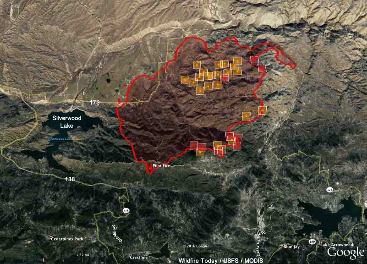
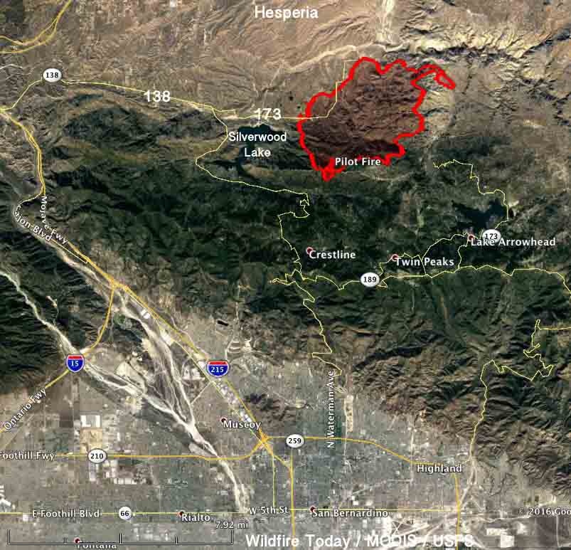
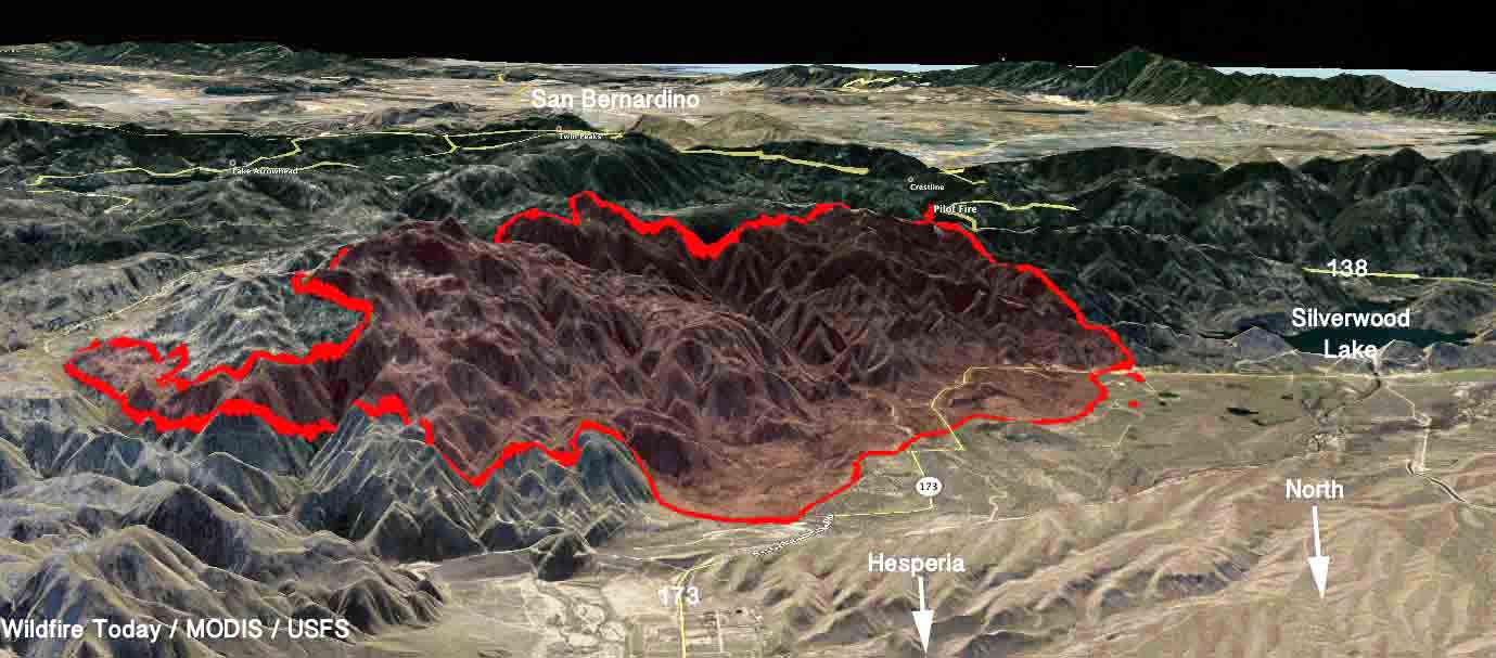
The map of the fire shows the fire perimeter from the Tuesday morning mapping flight, plus heat detected since then by a satellite. From 200 miles above the Earth the sensor only detects large heat sources, so there are likely many more small hot spots. But it is significant that all of the heat sources found are within or very close to the earlier perimeter. The accuracy of the satellite-detected data is supposed to be within 375 meters (1,230 feet). Scroll down to see other maps.

The numbers:
- 1,746 personnel
- 105 engines
- 46 hand crews
- 8 dozers
- 8 air tankers
- 12 helicopters
The incident management team has posted information on InciWeb about evacuations, road closures, trail closures, smoke, and drones, all of which are important, but there is not a lot of information about the fire itself such as the fire activity over the last 24 hours, where it was still spreading, what firefighters are doing, the use of aircraft, and where the open fireline is. Mr. Bently said that information was not available but should be later in the day.
****
(UPDATED at 6:55 a.m. PDT August 9, 2016)
The Pilot Fire north of Crestline, California continued to be active Monday on the west and south sides. The incident management team is calling it 6,963 acres.
At least 5,200 homes are under voluntary or mandatory evacuation orders.


On Monday there were 934 firefighters assigned, including 91 engines, 15 water tenders, 14 hand crews, 11 dozers, 7 helicopters, and approximately 6 air tankers, including two DC-10’s. The Angeles National Forest’s night flying helicopter has been assisting firefighters at night when conventional aircraft are grounded.
Check out this beautiful time-lapse video of the fire as seen from Silverwood Lake.
You will not get closer than this to having a plane dropping fire retardant on you! #PilotFire @NBCLA pic.twitter.com/UFXVEsuxNf
— Adrian Arambulo (@AdrianNBCLA) August 8, 2016
Phos-chek dropped on an area of the #PilotFire off hwy 173 @sbsun pic.twitter.com/yAMVG9pvqe
— Sarah Alvarado (@sarahalvarado) August 9, 2016
****
(UPDATED at 10:02 a.m. PDT August 8, 2016)
The spread of the Pilot Fire slowed Monday morning but that could change later in the day as the weather becomes hotter, drier, and the wind picks up. At 8:10 a.m. on the steep slope above Silverwood Lake near Crestline, California, the fire was backing slowly downhill as helicopters dipped water out of the lake.
Jeff Zimmerman sent us some excellent photos of the Pilot Fire he took Sunday.
A spokesperson for the San Bernardino National Forest said a night-flying fixed wing air attack aircraft with infrared capabilities determined that the fire has burned 4,500 acres.
On Sunday eight air tankers, including a DC-10 Very Large Air Tanker, assisted firefighters. Monday two water-scooping air tankers that Los Angeles County has borrowed from the province of Quebec begin their three-month contract. It will be interesting to see if they are used on the fire. Two large lakes, Silverwood and Arrowhead, are very close and would provide quick turnarounds for the aircraft that can drop up to 1,600 gallons of water.
A Type 2 incident management team led by Mike Wakoski has been dispatched and is due to inbrief at 9 a.m. on Monday.
The fire is being managed under a unified command with the U.S. Forest Service, CAL FIRE, San Bernardino County Fire, and San Bernardino County Sheriff’s Department.
Evacuations are still in effect and portions of Highways 173 and 138 are closed.
****
(UPDATED at 8:57 p.m. PDT August 7, 2016)
If you were watching the live video stream from EPN564, or watched it later, you saw that the Pilot Fire continued to be very active as the sun was setting. I believe it was shot from Highway 173 and the fire hit it pretty hard as it crossed the roadway in spite of numerous retardant drops by air tankers.
Seen dropping on the fire today were a BAe-146, a C-130, S2-T, and DC-10; there may have been more than one of each of those models.

San Bernardino County Fire tweeted that the fire has burned approximately 1,500 acres and is being fought by 400 personnel.
#PilotFire: (Update)1,500 acres,400 personnel,173 Closed between SR-138 & Arrowhead Lake rd https://t.co/pcQzaC7WIu pic.twitter.com/uYiqpe8h8W
— SB County Fire (@SBCOUNTYFIRE) August 8, 2016
#PilotFire retardant drop along Hwy 173 pic.twitter.com/5ZNnEPCBTR
— CAL FIRE BDU (@CALFIREBDU) August 8, 2016
#PilotFire photos from Vista Point near Silverwood pic.twitter.com/9lUcRDnSad
— Brandon Mawhorter (@airmo) August 8, 2016
****
(UPDATED at 6:40 p.m. PDT August 7, 2016)
The U.S. Forest Service reported that Highway 173 is closed between SR-138 and Arrowhead Lake Road, and Highway 138 closed from Old Mill Road to 173.
Evacuations have been ordered for the Summit Valley area east of Cedar Springs Dam.

****
Originally published at 4 p.m. PDT August 7, 2016.
The Pilot Fire was reported at about 12:10 p.m. PDT one mile east of Silverwood Lake in the San Bernardino National Forest in southern California. By 3 p.m. unofficial estimates from firefighting aircraft put it at around 1,000 acres.

It is being fought by numerous air tankers, but the remote location makes access for fire engines difficult or impossible. The wind, as recorded at the nearby Rock Camp weather station, has been from the south and southeast at 5 to 10 mph gusting to 20 mph, pushing the fire north toward Highway 173. Between that highway and the fire, there are very few structures, but there are some on the highway. Sunday afternoon the temperature was in the high 80’s and the relative humidity was around 20 percent.
The fire started near Pilot Rock Ridge, hence the name, “Pilot Fire”.


WATCH #LIVE: Crews battle #PilotFire in Silverwood Lake area https://t.co/u5lTveArpy pic.twitter.com/4HdUr01wNu
— ABC7 Eyewitness News (@ABC7) August 7, 2016
PEcom_news: RT NWSSanDiego: Smoke from #PilotFire seen on Doppler Radar. Winds out of the south gusting 15-20 mph.… pic.twitter.com/nHvNNbd0Ht
— Derill Brown (@Serial_Inventor) August 7, 2016

We will update this information as the incident develops.


While big fires always get attention; new breaking fires are still occurring. Another good example of quick response by air tankers and helicopters happened on the El Dorado N.F. on Saturday, Alder Fire. Although no two I.A. are the same this fire started in the afternoon in the same terrain and fuels as the disastrous Cleveland Fire of 1992. Within the first thirty minutes two Cal Fire S 2’s and two BAe 146’s from MCC (Sacramento) had dropped on the fire which had significant potential. Three helicopters worked the fire until cut-off. Done, 25 acres (timber) maybe thirty seconds mention on local T.V. station, maybe not?
i caught all that on my scanner as well.here in Auburn we had a small fire in our canyon,the Auburn Dam construction area,yesterday.though there were no retardant drops,copter 516 did make bucket drops.i dont have an acreage count,but it kicked up alot of smoke and had all nieghbors asking me what was going on.i use a power wheelchair with an anteana mounted and my scanner in my cup holder,and three doors up is a friend i worked the brush rig in summer with,between he and i,everyone comes to us for information when something bad happens in town.