Above: A firing operation on the Soberanes Fire by the Arroyo Grande Hotshots. Inciweb photo.
Soberanes Fire
This fire has been eating through the brush, grass, timber, and poison oak in the coastal mountains south of Monterey since July 22. In that time it has spread mostly to the south blackening over 91,000 acres.

The only large heat sources a satellite 200 miles overhead was able to detect in the last 24 hours were near the perimeter on the south and southeast sides. The Soberanes Fire is being fought by 1,4913 personnel including 21 hand crews; 65 engines; 12 helicopters; 21 dozers; and 14 water tenders.
The fire was caused by an illegal, unattended campfire on the Soberanes Canyon trail in the Garrapata State Park. The suppression costs to date are $160 million.
Poison oak is very prevalent in the area and some firefighters are saying it is the worst they have even seen. Five hundred have reported to the fire’s medical units for poison oak related ailments, with 200 cases in the past three days.
Rey Fire
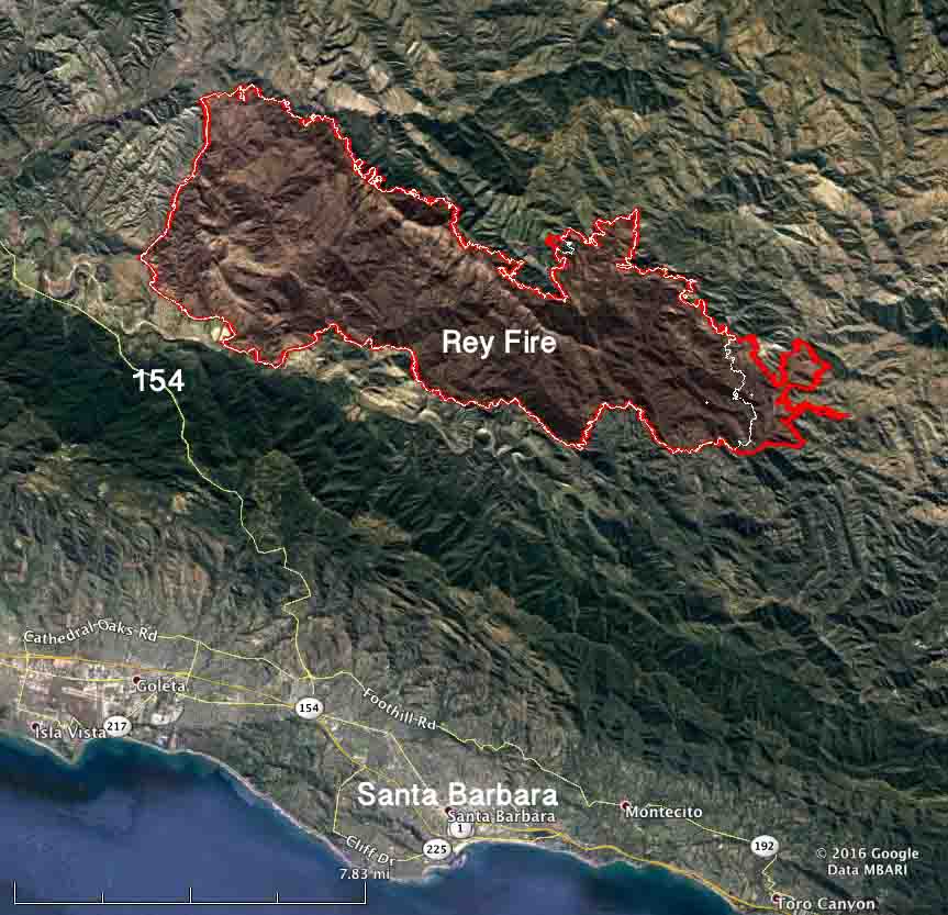
The Rey Fire north of Santa Barbara has been working its way east over the last several days but that growth has slowed as firefighters make progress by constructing direct firelines on the fire’s edge and completing contingency lines out ahead of the fire.

The Rey Fire typically slows to a crawl late at night when the marine layer moves in, then the activity increases in the afternoon. The incident management team is calling it 33,006 acres. Approximately 1,976 personnel are assigned to the fire, including 57 hand crews, 99 engines, and 18 helicopters.
Chimney Fire
The Chimney Fire near the central California coast has continued to spread to the north over the last few days through very rough and remote country east of the Hearst Castle.

CAL FIRE reports that 49 residences and 21 other structures have been destroyed, while 1,898 remain threatened. Some evacuation orders have been lifted but others are still in place.
The 45,000-acre Chimney Fire is being fought by 4,028 personnel, including 328 engines, 106 hand crews, 16 helicopters, 46 dozers, and 69 water tenders.


When the crews from the East and North would show up they always said “Poison Ivy [Toxicodendron radicans] doesn’t bother us, we’re used to it. But then they encounter Poison Oak [Toxicodendron diversiloba] and they get a real eye opener about how different and virulent the western plant is. I guess I should have said how eye closing it is…. Anyway in 1985 during the Gorda/Rat Creek fires (in the same area) there was so much poison oak being washed off of the firefighters in the shower unit that the concentrated oils made the shower unit flooring extremely slippery and gave severe poison oak reactions to the feet and legs of many of the camp personnel. I wonder if or how the shower unit at the Soberanes fire is addressing and mitigating this problem.
The Soberanes Fire poison ivy comments make me itch just reading about it. Poison ivy smoke can be really bad news for some people. Prayers for safety for the firefighters and residents.
Yes, the poison ivy smoke was something else I wondered about as some things could be toxic. Perhaps like the dangers of burning Oleander shrubs
Yes, back in 2014 my wife and I drove up along the Coast Hwy 1 and all the steep hillsides were all one massice Poison Oak habitat. In fact I wrote about this the first week of this fire in my blog. It’s literally everywhere. We drove up Palo Colorado Canyon Road which most tourists no nothing about and it was a beautiful place in the back country. But I agree, these firefighters are going to suffer big time with poison oak on this mountain range.
It’s sad to imagine most of Palo Colorado Canyon Road being eaten up by that fire. Some of the best chaparral specimens with ornamental horticultural value for the landscape could be found here.
http://timeless-environments.blogspot.se/2016/07/palo-colorado-canyon-now-paradise-lost.html