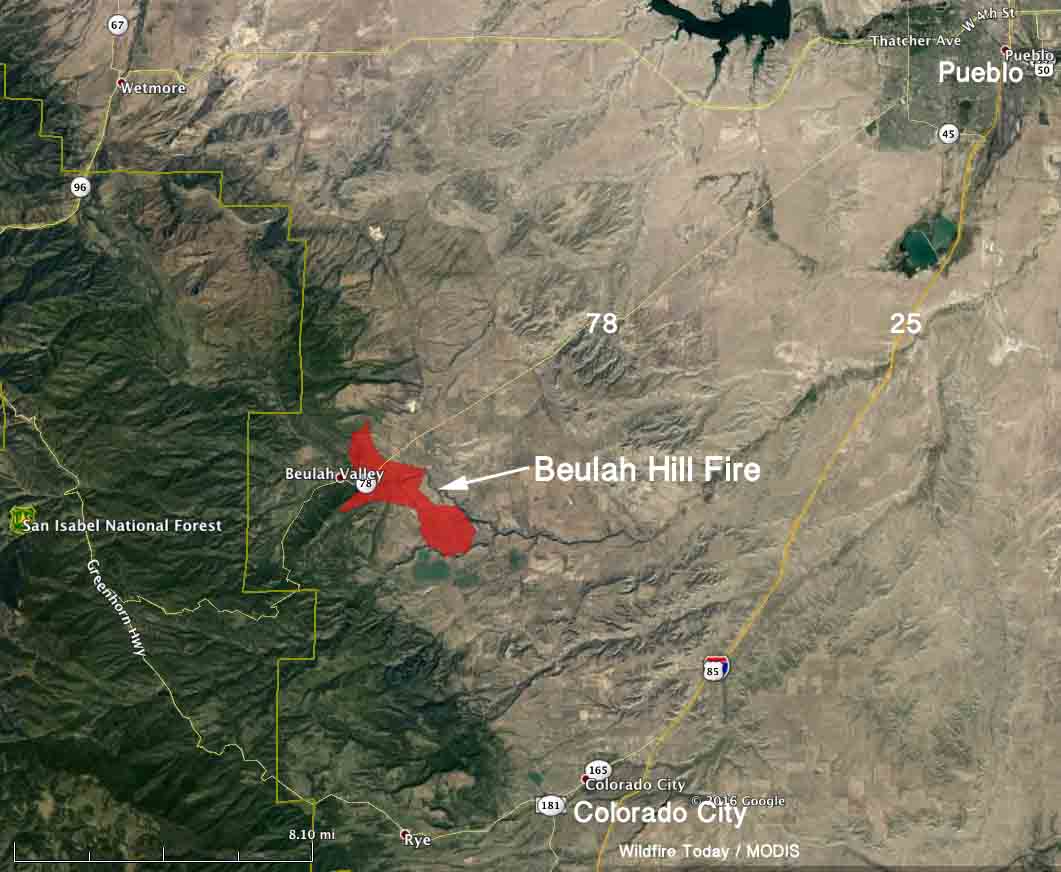
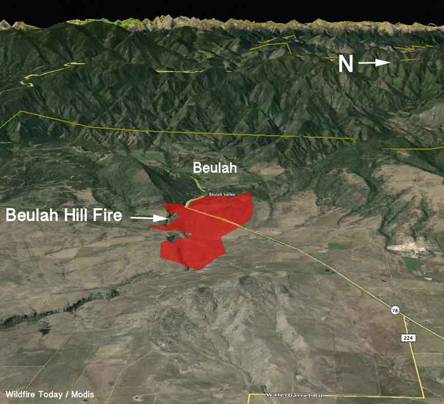
Above: Map of the Beulah Hill Fire at 12:20 p.m. MDT October 5, 2016. Data from Colorado’s MultiMission Aircraft.
(UPDATED at 11:43 a.m. MDT October 6, 2016)
Data from Colorado’s MultiMission aircraft has produced the map above showing the perimeter of the Beulah Hill Fire southwest of Pueblo, Colorado. The incident management team added the completed vs. open fireline, showing that more half of the fire’s edge is contained. The latest size estimate is 5,232 acres.
Fire officials today announced that the preliminary cause of the Beulah Hill Fire was a Colorado Department of Transportation excavator performing routine drainage maintenance work. It was moving rocks with the bucket and that may have created sparks, or it could have been hot particles from the exhaust. Investigators eliminated all other possible causes.
Officials also announced at a 10:30 a.m. press conference today that the state will be awarding each homeowner whose house burned a $5,000 grant to assist with immediate expenses.
Evacuation orders have been lifted in some areas.
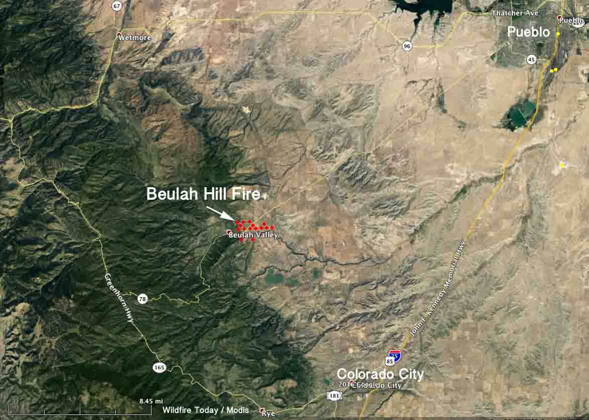
The MODIS satellite orbiting 438 miles overhead has not detected any large heat sources on the fire since it found one at 2:46 a.m. on October 5. But there are no doubt many small hot areas on the fire.
The yellow tape marks the point of origin for the #BeulahHillFire … This is the excavator the CDOT worker was using @KKTV11News pic.twitter.com/ec624gsLpC
— Kyla Galer (@kylagalerKKTV) October 6, 2016
****
(UPDATED at 10:47 a.m. MDT October 5, 2016)
As a result of better mapping, it has been determined that the Beulah Hill Fire has burned 4,848 acres 17 miles southwest of Pueblo, Colorado.
The number of structures burned has been revised to 8 homes and 16 outbuildings. Evacuations are still in effect for the Beulah area and approximately 200 homes still do not have electricity.
The Information Officer for the Type 2 incident management team that assumed command at 6 a.m. Wednesday announced Wednesday morning that firefighters have not achieved any containment (scroll down at the link) on the fire, saying it is at zero percent. The fire started early in the afternoon on Monday, October 1. In spite of the stated lack of containment the approximate number of personnel on the fire has decreased from 400 on Tuesday, to 340 on Wednesday (300 firefighters plus 30 to 40 overhead) over the last 24 hours according to the numbers provided over the last two days. Some incident management teams conflate the terms “contain” and “control”.
Other resources on the fire include 4 hand crews, 30 engines, 3 helicopters, 2 heavy air tankers, and 2 single engine air tankers.
****
(UPDATED at 4:15 p.m. MDT October 4, 2016)
At a 4 p.m. press conference fire officials at the Beulah Hill Fire in Colorado said progress on the fire is going pretty well. Since noon the fire grew by 300 to 500 acres, bringing the total to 5,100 to 5,300 acres. The winds were not as strong as predicted today, which allowed aircraft to assist the firefighters on the ground.
One large air tanker has been brought in from southern California and two single engine air tankers have been working on the fire, along with one heavy helicopter and two smaller helicopters.
Evacuations remain in place, still affecting about 700 homes and 1,950 residents, according to the Pueblo County Sheriff’s office.
The Type 2 Incident Management Team will inbrief at 4:30 p.m. today and will assume command of the fire at 6 a.m. on Wednesday.
#BeulahHillFire Several water drops happening over fire which has grown to 4800 acres. Still very windy down here. pic.twitter.com/laCBcRdfcZ
— KMcMackin (@KalynMcMackin) October 4, 2016
****
(UPDATED at 12:23 p.m. MDT October 4, 2016)
At a noon press conference fire officials said the Beulah Hill Fire southwest of Pueblo, Colorado has burned 4,800 acres, expanding in all directions since it started just after 12 p.m. on Monday. The winds, which are not as strong as yesterday, have allowed aerial resources to work the fire. Two helicopters are currently dropping water, a third is en route, and two Single Engine Air Tankers have also been ordered.
Approximately 400 personnel are assigned to the fire.
The video below shows an infrared heat-sensing view of the Beulah Fire followed by a normal view. Heat shows up as white. It was apparently recorded at 6:05 p.m. MDT on Monday, if we’re interpreting the data on the screen correctly. The fire was reported at 12:30 p.m. MDT Monday. The video was recorded by one of the two Pilatus PC-12 Multi-Mission aircraft owned by the state of Colorado.
Video from one of the MMA mission’s to the #BeulahHillFire pic.twitter.com/MwxCJAGpQB
— COFirePrev&Control (@COStateFire) October 4, 2016
****
(UPDATED at 10:35 am MDT October 4, 2016)
The video above was uploaded to YouTube October 3 by Storyful News, courtesy of “Kristina Jeff Finn”.
The Beulah Hill Fire 18 miles southwest of Pueblo, Colorado continued to spread overnight but as the winds decreased so did the growth of the fire.
The entire Beulah Valley is under evacuation orders affecting about 700 homes and 1,950 residents, according to the Pueblo County Sheriff’s office.
Fire spokesperson Gail Perez said seven structures have been destroyed. The Rocky Mountain Area Coordination Center reported at about 10 am today that the fire has burned approximately 8,000 acres. A Type 3 Incident Management Team with Incident Commander Paul Duarte is managing the fire and a Type 2 Team with IC Greer has been ordered.

The weather forecast for the fire area issued by the National Weather Service Monday night predicted relatively benign winds for Tuesday, at 6 to 8 mph, but the revised forecast Tuesday morning is very different and includes a Red Flag Warning. The wind speeds will increase through the morning and early afternoon, reaching 17 mph out of the northwest by noon and building to 20 mph at 4 p.m. with gusts of 30. After dark they will again slow to 6 mph from the northwest and west. The temperature will top out at 68 today with a relative humidity of 12 percent.

These wind conditions will again make it difficult for aerial firefighting resources to be effective. On Monday a helicopter responded toward the fire but had to be grounded most due to the wind. Ms. Perez could not confirm if any aircraft had been ordered for Tuesday.

In a cruel twist of fate, the 747 air tanker that has just been rebuilt sits 50 miles away from the fire at Colorado Springs. Tanker 944 can carry 19,600 gallons of fire retardant, 10 times more than a P2V, 6 times more than a BAe-146, and almost twice as much as the DC-10. It could most likely reload with retardant at the Pueblo airport 34 miles away from the fire.
The 747 has completed testing, is certified by the FAA, and is waiting on approval from the U.S. Forest Service and the Interagency Airtanker Board before it can be used on a federal fire in the United States. However, this fire is not on federal land. And, of course, it would need a contract to be used on anyone’s land.
****
(Originally published at 9:30 p.m. MDT October 3, 2016)

The Beulah Hill Fire 18 miles southwest of Pueblo, Colorado has caused road closures, evacuations, and according to KOAA has burned approximately seven structures. The fire started early Monday afternoon three miles east of the San Isabel National Forest in a local fire protection area. The incident commander reports it has burned about 3,000 acres.

It was pushed by a strong wind on Monday which limited the use of aerial firefighting resources. According to a weather station north of Colorado City the direction was quite variable, but it was blowing at 8 to 16 mph with gusts of 35 to 44 mph. The temperature on Monday got up to 79 degrees with a relative humidity of 12 percent. The forecast for Monday night through Wednesday is for the wind to decrease significantly, and should be out of the west and northwest at 6 to 8 mph along with high temperatures in the 60s and minimum humidities in the teens.

The Pueblo County Sheriff’s Office has ordered evacuations in several areas and a section of highway 78 is closed.
A rancher watches #wildfire after using his tractors to dig fire lines in Pueblo County near the town of Beulah. @denverpost pic.twitter.com/YUHCXK6RBi
— RJ Sangosti (@RJSangosti) October 4, 2016
Our radar is showing some of the smoke from the #beulahhillfire that has moved NE along Highway 78 towards Pueblo pic.twitter.com/Tqr3yu04C5
— KKTV 11 News (@KKTV11News) October 3, 2016


That is so scary! Those are incredible images of the fire.
What ever happened to the Center of Excellence for the Advanced Technology of Aerial Fire Fighting, (CoE)? With the Super Tanker 747 sitting just miles away from this fire, I would have thought that someone would have taken the initiative from either the State side or private sector to proceed with a prove of performance interim contract (CWN) for the Super Tanker, written by the State of Colorado for the State of Co. If C.D.F. hadn’t proceeded with the DC 10 program who knows where 10 Air Carrier would have been (or not been) today? Colorado asking for a tanker from California? The State of Colorado PC12s (ATGS and ASM) what is up with not getting these aircraft into the low level mix? Unfortunately the answer to many of these questions revolves around the deep pockets of the U.S. Government. Evergreen toured the globe with their 747 taking action on several fires as far away as Israel. Pueblo to Colorado Springs is a lot closer than Israel. (profound statement)
Beulah’s own meteorologist clocked the wind on Monday at 53 mph at one point. Check “Wet Mountain Weather” on Facebook if you use FB. It’s not blowing as hard today.
The whole thing is just like the Wetmore Fire of October 2012, only two drainages further south — same conditions.