Above: A November 29 infrared image of an area within the Chimney Tops 2 Fire in Seivier County, Tennessee. The white areas represent heat, areas that either ARE burning or they previously burned and retained some of the heat. For example, a concrete slab, ashes, and bricks would stay hot for hours after most of the fire burned out or was extinguished. The larger white rectangular objects are most likely burned structures.
On Wednesday afternoon officials confirmed that 700 structures burned in the Chimney Tops 2 Fire in Tennessee. Of that total, 300 were in Gatlinburg and 400 were in other parts of Sevier County.
The Tennessee Department of Health reported Wednesday that the death count in the fire has risen to seven and the number of injuries has increased to 45.
A mandatory evacuation is still in effect for most of the City of Gatlinburg.
Fire suppression resources assigned to the fire include 9 hand crews, 22 engines, 7 helicopters, 4 dozers — for a total of 285 personnel.
As predicted, another round of rain assisted firefighters on Wednesday, dropping between 1.28 and 1.76 inches at four weather stations in the Gatlinburg area during the 24 hours ending at 11:50 p.m. EST.
Precipitation recorded at four weather stations in the Gatlinburg area during the 24-hour period ending at 11:50 p.m. EST November 30, 2016. Click to enlarge.
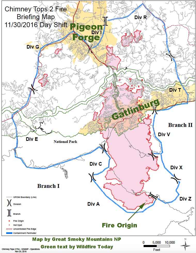
Briefing map of the Chimney Tops 2 Fire. Prepared by Great Smoky Mountains National Park November 29, 2016 for the November 30 day shift. The green text was added by Wildfire Today. Click to enlarge.
As far as we know this is the first publicly available map of the Chimney Tops 2 Fire that burned from Great Smoky Mountains National Park into Gatlinburg and Pigeon Forge, Tennessee. The incident management team reports it has burned 15,653 acres.
We are not aware of an official estimate of the number of structures destroyed in the fire since Tuesday morning’s report from the Tennessee Emergency Management Agency (TEMA) of approximately 100 homes in Sevier County Tennessee having been either damaged or destroyed.
WBIR has a list of areas affected by the fire with brief descriptions of the damage. From that information it appears that the number of structures destroyed will be much larger than the early estimate.
On Wednesday a Type 1 Incident Management Team run by Mike Dueitt assumed command of the Chimney Tops 2 Fire. Teams like this are made up of federal and state interagency team members from across the country who collaboratively manage wildland fires and other natural disasters.
The evacuation of Pigeon Forge has been lifted but is still in effect for Gatlinburg.
Firefighters will be aided on Wednesday by rain. The NWS predicts a 73 to 100 percent chance of precipitation into the evening with accumulations of about a third of an inch.
Those are words spoken by a resident trying to escape from the fire in the Chalet Village area near Gatlinburg, Tennessee as he drove down a road with fire on both sides.
Above: The amount of rain expected during the 6 hour period ending at 1 p.m. ET November 30.
Wildfires that have been burning for weeks in the Southeast within 200 miles of where the states of Georgia, North Carolina, and South Carolina come together have been plaguing residents for weeks. Smoke created by the blazes at times has been covering large portions of the South.
A drought lasting many months, and at least some cases of arson, are what led to the necessity for about 4,000 firefighters to be deployed to put out the dozens of large fires burning at the same time.
But that is about to change.
Beginning Monday night, November 28, rain in this area will slow the spread of the fires for many days at least. Some fires, but probably not all, may be put out by the time the rain ends Wednesday night. Gatlinburg, where two fires in Great Smoky Mountains National Park on Monday are causing evacuations, should receive more than 2 inches between Monday night and Wednesday night.
These three maps, that are just for six-hour periods, indicate the significant precipitation expected for the next two days.
The forecast for precipitation during the 6 hours ending at 7 a.m. ET Tuesday November 29 2016.
*
*
*
The forecast for precipitation during the 6 hours ending at 7 a.m. ET Wednesday November 30 2016.
Sevier County officials reported that there have been three fatalities related to the fires in the Gatlinburg, Tennessee area. Sevier County includes Pigeon Forge, Gatlinburg, and part of the Great Smoky Mountains National Park. At least 14 people have been injured.
Three individuals with severe burns were transferred from the University of Tennessee’s Knoxville (UTK) Hospital to Vanderbilt Medical Center in Nashville Monday night. A fourth person with burns to their face continues to be evaluated at UTK.
Pigeon Forge officials estimate 500 people were evacuated on Monday night. Approximately 125 people remain displaced and in local shelters in Pigeon Forge. About 14,000 residents and visitors evacuated from Gatlinburg.
The National Park service estimates that a total of 15,000 acres have burned in Great Smoky Mountains National Park and in the areas in and around Gatlinburg and Pigeon Forge. On Wednesday the NPS will transfer command of the fires within the park to a Type 1 Incident Management Team run by Mike Dueitt. Teams like this are made up of federal and state interagency team members from across the country who collaboratively manage wildland fires and other natural disasters.
Map of the Gatlinburg, TN area, November 29, 2016.
Eventually we hope to obtain a map, much better than the one above, of the fires in the Gatlinburg area. Check back later. (UPDATE: we posted a much better map on November 30.)
We do not yet have complete information about how many fires are burning, where they are, the causes, and where all of the fire(s) started that eventually burned into the communities of Gatlinburg and Pigeon Forge.
The NPS reported Tuesday morning that 80 mph winds gusts, low humidities, and drought conditions…
…caused the fire burning in the National Park to spread rapidly and unpredictably, in spite of suppression efforts on Sunday that included helicopter water drops. Wind gusts carried burning embers long distances causing new spot fires to ignite across the north-central area of the park and into Gatlinburg. In addition, high winds caused numerous trees to fall throughout the evening on Monday bringing down power lines across the area that ignited additional new fires that spread rapidly due to sustained winds of over 40 mph.
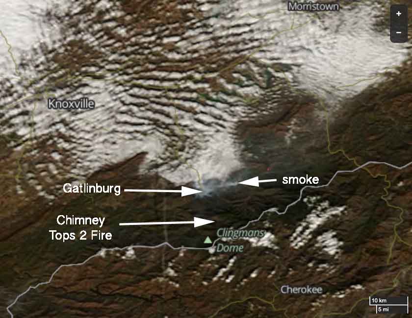
Presumably the fire within the park was the Chimney Tops 2 Fire, which started November 23 and was reported to be 10 acres Sunday evening, November 27. Apparently the NPS was not able to completely suppress the fire during that four-day period.
The Tennessee Emergency Management Agency, in their Tuesday update, wrote:
The Chimney Top Fire, which began in the Great Smoky Mountains, spread very rapidly yesterday evening as high winds pushed flames onto private property.
They were probably referring to the Chimney Tops 2 Fire.
****
(UPDATED at 10:13 a.m. EST November 29, 2016)
About 100 homes in Seiver County Tennessee have been either damaged or destroyed in wildfires that started in or near Great Smoky Mountains National Park in eastern Tennessee. The state’s Emergency Management Agency (TEMA) which conducted a quick preliminary survey, reported at 3 a.m. ET Tuesday that about 10 of those homes were in Gatlinburg. In addition, 30 other structures in Gatlinburg have been damaged or destroyed, including a 16-story hotel on Regan Drive and the Driftwood Apartments near the Park Vista Hotel.
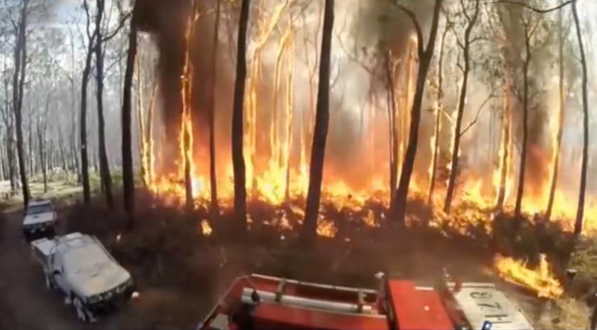
Above: Country Fire Authority test of engine burnover protection systems. Screen shot from CFA video.
The Aussies are far ahead of wildland firefighting agencies in the United States when it comes to the protection of personnel during fire engine burnovers and rollovers. Since 1977 Victoria’s Country Fire Authority (CFA) has been creating, evolving, and improving systems to increase the odds of firefighters on an engine surviving if their position is overrun by fire. These efforts were intensified after two engine burnovers in 1983 and 1998 killed a total of 17 firefighters.
During the last 39 years the vehicles have been hardened in various ways. Examples include internal radiant heat curtains and nozzles positioned around the exterior of the truck that spray water as the fire approaches.
We did a quick search on Wildfire Today for “engine burnover” and were surprised at the number of results. Take a moment and at least look at the titles and brief excerpts. These, of course, are just articles on our website. We make no claim that all engine burnovers are included since we started this website in 2008.
On November 21 the CFA posted a video (below) about their crew protection systems. It covers the history of their efforts and several minutes of video recorded during a test when a fire was ignited that burned over three of their engines to evaluate the effectiveness of the designs. The maximum temperature recorded was 728°C (1,342°F)
Below is a screen shot from the CFA video.
Country Fire Authority test of engine burnover protection systems. Screen shot from the CFA video.
What if — in 2006 the five U.S. Forest Service firefighters that were entrapped and killed on the Esperanza Fire, instead of working on an engine similar to the USFS engine farther down this page, had been assigned to one built to CFA standards. Would they have taken refuge in the engine, pulled down the thermal protection shields and turned on the truck protection water spray instead of attempting to survive the fire outside the engine?
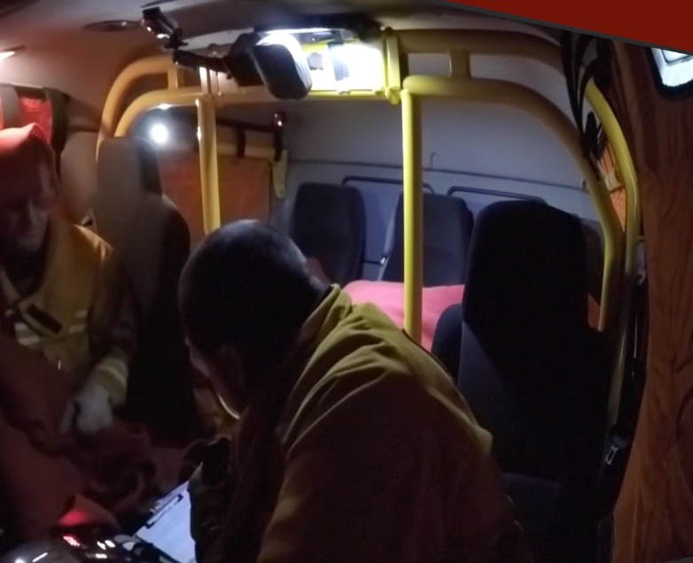
One feature of the CFA engines we noticed was a heavy-duty internal roll bar.
Internal roll bar in a Country Fire Authority engine.
We have written before about the need for U.S. wildland firefighting agencies to improve the survivability of engine crews during rollovers. These accidents involving large fire trucks, especially water tenders, are common.
In our opinion it is disgraceful that the outfits employing thousands of firefighters on engines have not taken this step to provide a safer working environment for their personnel.
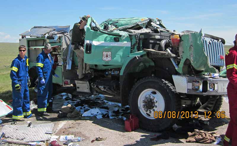
On August 8, 2013 Engine 492 from the Medicine Bow-Routt National Forest and Thunder Basin National Grasslands was involved in a rollover accident on Wyoming State Highway 450 southwest of Newcastle, Wyoming. Three firefighters were injured, one seriously.
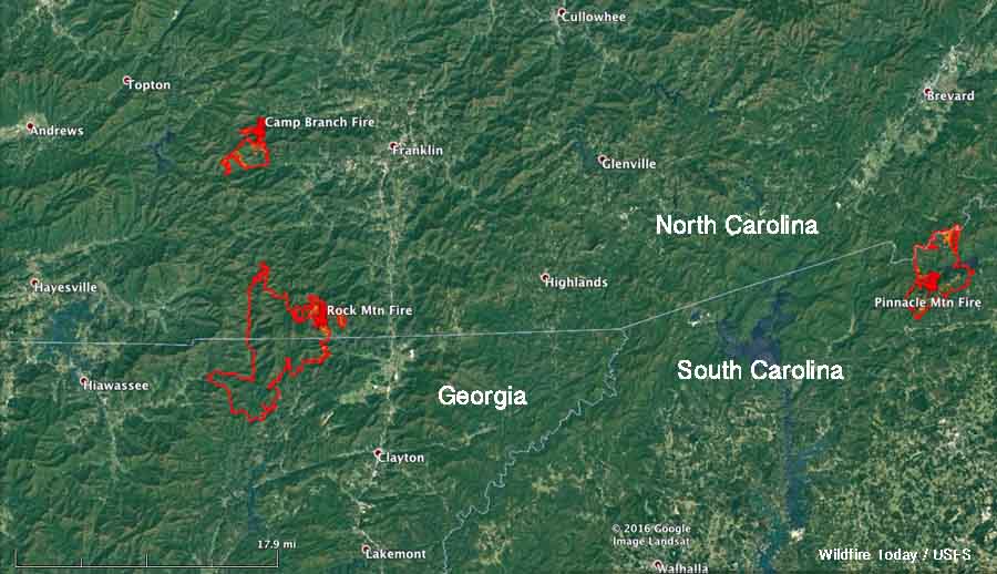
Above: Three fires were generating the smoke detected by a satellite on November 27: Rock Mountain, Camp Branch, and Pinnacle Mountain Fires.
The wildfire activity in the southern states has slowed a bit over the last few days. The day before Thanksgiving there were about 4,100 personnel assigned to fires in the area. By Saturday that number had decreased to 3,400.
The smoke generated by fires that has plagued residents for weeks has also diminished considerably. Today’s satellite photo, above, only shows three fires that are creating enough smoke to be seen from hundreds of miles overhead. These are the Rock Mountain (Georgia and North Carolina), Camp Branch (North Carolina), and Pinnacle Mountain Fires (South Carolina).
Just five fires in the Southern Geographic Area reported size increases on Saturday — a major change from recent weeks.
Rock Mountain Fire
The Rock Mountain Fire in Georgia and North Carolina grew by 2,578 acres in the last 48 hours and now has covered 20,647 acres, which is considered huge in this part of the country. It has spread to within 4 miles of Otto, NC and 4 miles of Dillard, GA. The fire was mapped Saturday by Colorado’s MultiMission Aircraft. Firefighters reported active surface spread in hardwood leaf litter in all directions, aspects and elevations on Saturday. Where it was not impacted by suppression it spread for half a mile. About 130 structures are threatened.
Camp Branch Fire
The 1,483-acre Camp Branch Fire is 9 miles west of Franklin, NC, an increase of 120 acres over the previous report. About 113 personnel are assigned to this fire which currently threatens 140 structures. On Saturday firefighters successfully conducted burnout operations on the northwest and southeast sides.
Pinnacle Mountain Fire
The Pinnacle Mountain Fire in Table Rock State Park added 217 acres Saturday to bring the total up to 9,147 acres. It is in northwest South Carolina 9 miles south of Brevard, North Carolina. The incident management team reports that 255 personnel are assigned and 1,133 structures are threatened. A burnout operation on Saturday brought the perimeter to the containment lines on the west and north sides of the fire.
Map showing the perimeters of the Rock Mountain, Camp Branch, and Pinnacle Mountain Fires.
OTHER FIRES
Clear Creek Fire
The Clear Creek Fire is 7 miles northwest of Marion, NC. I has burned 2,986 acres, an increase of 363 acres. About 352 structures are reported to be threatened. The fire is staffed by 489 personnel.
Mount Pleasant Fire
The Mount Pleasant Fire, 9 miles west of Buena Vista, Virginia has blackened 11,200 acres, an increase of 200. High humidity Friday night aided suppression efforts, but that was followed by strong winds on Saturday. Area road and trail closures, including part of the Appalachian Trail, are in effect. The fire has burned across the Appalachian Trail between Road 507 and Cow Camp Gap. The increase in acreage was the result of a large burnout operation on Saturday.
For the latest articles at Wildfire Today about how smoke from the wildfires is affecting various locations in the South, check out the articles tagged “smoke”.
The 747 Supertanker, T-944, drops on a fire in Israel northwest of Jerusalem on November 26, 2016. Screen grab from video by @ShaiBenari
The 747 Supertanker, Tanker 944, dropped on a wildfire in Israel today northwest of Jerusalem. This was the first drop on a fire this version of the Supertanker has made.
After a 12.5-hour non-stop flight from Colorado Springs the aircraft arrived in Tel Aviv at about 10:25 a.m. MST time on November 26, which was after dark at the Ben Gurion International Airport.
The drop made today occurred at around sunset.
Jim Wheeler, President and CEO of Global SuperTanker Services, said it dropped the entire 19,200-gallon load of water. While sometimes air tankers in Israel drop fire retardant, he explained that the authorities often prefer water when the aircraft is working over populated areas.
Shai Ben-ari (@ShaiBenari) recorded a video of the drop. The image above is a screen grab from the video. And, here is another video, by @Israel, which shows the entire drop. Below is a screen grab from that second video.
Screen grab from a video by @Israel of the Supertanker dropping northwest of Jerusalem, November 26, 2016.
Before the drop the 747 took off from Tel Aviv and loitered over the Mediterranean for a while before it apparently made a dry run over the fire and then dropped on the next pass. The entire flight lasted about two hours.